Edmundston Airport
| Edmundston Airport | |||||||||||
|---|---|---|---|---|---|---|---|---|---|---|---|
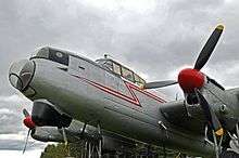 Lancaster KB882 display at Edmundston Airport | |||||||||||
| Summary | |||||||||||
| Airport type | Public | ||||||||||
| Operator | Aéroport Madawaska Airport Inc | ||||||||||
| Location | Edmundston, New Brunswick | ||||||||||
| Time zone | AST (UTC−04:00) | ||||||||||
| • Summer (DST) | ADT (UTC−03:00) | ||||||||||
| Elevation AMSL | 498 ft / 152 m | ||||||||||
| Coordinates | 47°29′24″N 068°28′54″W / 47.49000°N 68.48167°WCoordinates: 47°29′24″N 068°28′54″W / 47.49000°N 68.48167°W | ||||||||||
| Map | |||||||||||
 CYES Location in New Brunswick | |||||||||||
| Runways | |||||||||||
| |||||||||||
Edmundston Airport (ICAO: CYES) is located 9 nautical miles (17 km; 10 mi) northwest of Edmundston, New Brunswick, Canada along the east bank of the Madawaska River.
The airport is unique among Canadian airports in that its runway straddles the interprovincial border between New Brunswick and Quebec and is located in Patrieville, New Brunswick in Madawaska County and Dégelis, Quebec in the Témiscouata Regional County Municipality.
The airport is classified as an airport of entry by Nav Canada and is staffed by the Canada Border Services Agency (CBSA). CBSA officers at this airport can handle general aviation aircraft only, with no more than 15 passengers.[1]
The airport featured a World War II-era Lancaster KB882 on display outside the terminal building since 1964. The aircraft was relocated in 2017, to the National Air Force Museum of Canada.[3]
References
- 1 2 Canada Flight Supplement. Effective 0901Z 19 July 2018 to 0901Z 13 September 2018.
- ↑ Synoptic/Metstat Station Information Archived December 1, 2011, at the Wayback Machine.
- ↑ Joanna Calder (October 3, 2017). "Edmundston Lancaster KB882 transferred to National Air Force Museum of Canada". www.rcaf-arc.forces.gc.ca. Retrieved 2 July 2018.
| By name | |
|---|---|
| By location indicator | |
| By province/territory | |
| By area | |
| National Airports System | |
| Related | |
| |