Edmundston–Madawaska Bridge
| Edmundston–Madawaska Bridge | |
|---|---|
 | |
| Coordinates | Coordinates: 47°21′36.5″N 68°19′43.3″W / 47.360139°N 68.328694°W |
| Crosses | Saint John River |
| Characteristics | |
| Design | through truss |
| Material | steel |
| Total length | 287.12 metres (942.0 ft) |
| History | |
| Construction start | 1920 |
| Opened | 1921 |
| Statistics | |
| Daily traffic | 2,082 |
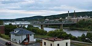
The Edmundston–Madawaska Bridge is an international bridge which connects the cities of Edmundston, New Brunswick, in Canada and Madawaska, Maine, in the United States, across the Saint John River.[1] The bridge consists of four steel through truss spans, each 70.71 metres (232.0 ft) in length, for a total length of 287.12 metres (942.0 ft), which carries a two lane open steel grid deck roadway.
The bridge was constructed in 1920, replacing a cable ferry, and opened in 1921. Its original asphalt and timber deck was replaced with the current steel grid deck in 1961.
Transport Canada estimated the bridge's traffic at 759,803 vehicles annually in 2006.
Effective October 27, 2017 The Edmundston-Madawaska International Bridge weight restriction was reduced to 5 tons.
Vehicles over 5 tons will be rerouted to Clair POE located 33 km north and St-Leonard POE is located 41 km south of Edmundston
References
- ↑ Edmundston–Madawaska Bridge
External links
| Wikimedia Commons has media related to Edmundston–Madawaska Bridge. |