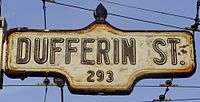
Dufferin Street
| |
|---|---|
| York Regional Road 53 | |
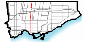 Dufferin within Toronto | |
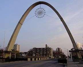 The Dufferin Gates at Exhibition Place at the foot of Dufferin Street. | |
| Route information | |
|
Maintained by City of Toronto Vaughan Township of King | |
| Major junctions | |
| South end | Exhibition Place (Continues as British Columbia Road through the Exhibition grounds) |
|
King Street Queen Street Dundas Street Bloor Street St. Clair Avenue Eglinton Avenue Lawrence Avenue Wilson Avenue ------Road Breaks------ Finch Avenue Steeles Avenue Graham Sideroad | |
| North end | Holland Marsh |
| Location | |
| Major cities |
Toronto Vaughan |

Dufferin Street is a major north-south street in Toronto, Vaughan and King Ontario, Canada. It is a concession road, two concessions (4 km) west of Yonge Street. The street starts at the foot of Lake Ontario, continues north to Toronto's northern boundary at Steeles Avenue with some discontinuities and continues into Vaughan, where it becomes York Regional Road 53. The street is named for Frederick Hamilton-Temple-Blackwood, 1st Marquess of Dufferin and Ava, who served as Governor General of Canada from 1872 to 1878. In 2003 and 2007, it was voted as one of "Ontario's Worst 20 Roads" in the Ontario's Worst Roads poll organized by the Canadian Automobile Association.[1][2]
Route description
Lake to Queen Street
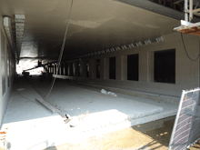
The southern end of Dufferin is within the Exhibition Place (holds the annual Canadian National Exhibition (CNE)) at Dufferin Gates. The two Dufferin Street bridges connect the Exhibition Place with the rest of Dufferin Street to the north. The bridge span over the railway north of the CNE grounds was determined to be unsafe for vehicular traffic in 2013. The span, dating from 1911, is closed to vehicles until a replacement bridge is ready in early 2014. The bridge is scheduled for replacement starting in 2016.[3] The City of Toronto plans to build a temporary bridge to restore vehicular traffic in advance of the replacement construction.[4]
North of the CNE grounds, the east side is dominated by industrial or transitional industrial to residential and commercial buildings of Liberty Village, with several old factories being converted to loft-style condominiums. The west side is mostly single-family homes with one apartment building south of King Street. The neighbourhood to the west is named Parkdale, which was developed mostly before 1900.
Queen Street to Eglinton Avenue
North of Queen Street West, Dufferin is primarily residential on both sides, with the large Dufferin Mall on the west side of Dufferin, south of Bloor Street. This was the former site of the Dufferin Park Racetrack. Across the street from the mall is the Dufferin Grove city park. From Queen Street north to College Street, the neighbourhood is known as Little Portugal. North of College, and west of Dufferin is the former village of Brockton and on the east is the Dufferin Grove neighbourhood, named after the park on the east side of Dufferin. Dufferin station is located at Dufferin and Bloor Street on Line 2 Bloor–Danforth of the Toronto subway system.
From Bloor Street to Davenport, Dufferin is lined with homes built from the 1920s to post-World War II. The Galleria Shopping Centre is located on the west side of Dufferin and on the south side of Dupont Street. The neighbourhood west of Dufferin in this area is known as Wallace Emerson, while on the east it is known as Dovercourt Park. North of Davenport, Dufferin ascends the former Lake Iroquois shoreline escarpment. North of the escarpment, the street continues to be residential on both sides north to Eglinton Avenue West. Between Rogers Road and Eglinton Avenue West, Dufferin crosses two steep ravines.
Eglinton Avenue to Wilson Avenue
North of Eglinton Avenue, it becomes a six-lane arterial road through industrial and low-density commercial lands of the former North York. The regional shopping centre of Yorkdale Shopping Centre is located at Dufferin and Highway 401. The sections from Eglinton into York Region was originally Vaughan Road.
North of Sheppard Avenue
North of Wilson Avenue, Dufferin is interrupted by Downsview Airport and Allen Road, the latter of which feeds Dufferin north of Kennard Avenue (formerly Wilson Heights Boulevard), north of Sheppard Avenue.
A broken section of Dufferin Street runs parallel with Allen Road, one block east, south of the continuation from Allen Rd., from Sheppard Ave. to Kennard Ave. This section is a residential street and ends in a cul-de-sac just south of Kennard. North of Wilson, Dufferin Street runs 210 metres (690 ft) to Katherine Street and continues on as Beffort Road/Hanover Road.
North of Steeles Avenue
Dufferin Street continues north of Steeles Avenue into the city of Vaughan. The section north to Highway 7 and Langstaff Road is a six-lane arterial road, designated as York Regional Road 53. North of that, it narrows to four lanes, then narrows again two blocks north of Major Mackenzie Drive to two lanes. North of Lloydtown/Aurora Road (York Road 16) / 18th Sideroad (York Road 26), it is maintained by King Township and terminates just north of Graham Sideroad in the Holland Marsh, after jogging at Davis Drive (York Road 31), the former Highway 9.
Dufferin jog
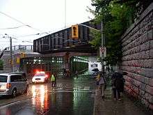
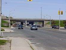
The intersection of Dufferin Street and Queen Street West also intersects with the main railway line from downtown to the northwest. The location was the site of the Parkdale Train Station and it was originally a level crossing. In the 1890s, an underpass (initially called "the subway") was built for Queen Street to accommodate growing east-west traffic; however, one was not built for Dufferin Street to connect it a block north of Queen. At the time, the area north of the railway line was heavily industrial and factories backed onto the tracks. North-south traffic was not expected or planned for and the two sections of Dufferin were not connected.[5] As automobiles arrived in Toronto around 1903, and for the next 107 years, vehicles looking to travel along Dufferin detoured around the closed section to Peel (east-west) and Gladstone (north-south), which became de facto sections of Dufferin. The detour was known locally as the Dufferin Jog.
The jog was eliminated in 2010 with the construction of a four-lane underpass beneath the railroad track, including public art and an amphitheatre-styled park with tiered gardens at the southwest corner of the underpass. This project was approved by city council in 2007, and work on extending the roadway began on July 2009.[6] The underpass was opened on November 18, 2010.[7] A further widening of the north side of the bridge was completed in 2016-2017 to support expanded GO Transit train service.[8]
The section of the east side of the bridge along Queen Street was built in 1897 as the Queen Street Subway.
Italian community
Dufferin Street has long been an important thoroughfare for Toronto's Italian community. An Italian neighbourhood developed around Dufferin and Davenport in the 1890s and soon became known as "little Little Italy". In the 1950s, Italian-Canadians from the main Little Italy around College Street and Grace Street headed northwest up Dufferin past St. Clair Avenue and were joined by a new wave of immigrants from Italy. By the 1960s, the Dufferin-St. Clair area (known as Corso Italia) had supplanted College-Grace Little Italy as the largest centre of Toronto's Italian community. There is also a large Italian-Canadian presence along much of the suburban sections of the street as well, in both Toronto and Vaughan.
Public transit
The 29 Dufferin and 929 Dufferin Express bus routes runs from the lake shore along the full length of Dufferin to the Wilson Station. When the CNE is not operating, the Dufferin bus continues south within Exhibition Place to the Bathurst streetcar loop. The bus connects with the Toronto Bloor-Danforth Subway at Dufferin Station and the Yonge-University-Spadina line at Wilson Station.
The 29 Dufferin bus was the busiest bus route in the TTC in 2007 and 2008, with an average 43,600 riders each weekday.[9] As of 2010 it was the fifth busiest route, with an average of 39,700 riders per weekday.[10] Buses run every two to ten minutes on the route, depending on the time of day.
The 105 Dufferin North bus route runs north from Sheppard West Station along Allen Road and Dufferin Street to Steeles Avenue.
North of Steeles Avenue operates the York Region Transit 105 Dufferin along Dufferin Street, running from Sheppard West Station to Major Mackenzie Drive in Vaughan.
References
| Wikimedia Commons has media related to Dufferin Street, Toronto. |
- ↑ "Ontario's worst municipal roads – top 20". Canadian Automobile Association. 2007. Archived from the original (PDF) on October 6, 2007. Retrieved December 26, 2007.
- ↑ "Top 20 Worst Municipal Roads in Ontario for 2007". Canadian Automobile Association. 2007. Archived from the original on January 3, 2008. Retrieved December 26, 2007.
- ↑ Moloney, Paul (May 31, 2013). "City to close Dufferin St. bridge north of Exhibition Place". Toronto Star.
- ↑ "Dufferin Street Bridge over rail corridor to be closed" (Press release). City of Toronto. May 31, 2013.
- ↑ "Dufferin: Toronto's kinkiest street". Toronto Star. May 16, 2010.
- ↑ Mackenzie, Robert (July 15, 2009). "Dufferin / Queen construction affects transit service this weekend". Transit Toronto. Retrieved July 18, 2009.
- ↑ McGinnis, Rick (November 13, 2010). "Dufferin Underpass to replace Dufferin jog will open November 18". BlogTO. Retrieved November 17, 2010.
- ↑ http://gordperks.ca/wp-content/uploads/2016/07/Dufferin-Street-Bridge-Flyer-FINAL.pdf
- ↑ "Operating Statistics" Toronto Transit Commission: http://www3.ttc.ca/About_the_TTC/Operating_Statistics/2008.jsp
- ↑ "Operating Statistics" Toronto Transit Commission: http://www3.ttc.ca/About_the_TTC/Operating_Statistics/2010.jsp
External links
Google Maps of Dufferin Street
Major roads, highways and streets in Toronto | |||||||||
|---|---|---|---|---|---|---|---|---|---|
| North–south |
| ||||||||
| East–west |
| ||||||||
| |||||||||
| |||||||||