Dovre
| Dovre kommune | |||
|---|---|---|---|
| Municipality | |||
 | |||
| |||
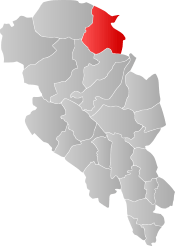 Dovre within Oppland | |||
| Coordinates: 62°2′6″N 9°28′3″E / 62.03500°N 9.46750°ECoordinates: 62°2′6″N 9°28′3″E / 62.03500°N 9.46750°E | |||
| Country | Norway | ||
| County | Oppland | ||
| District | Gudbrandsdalen | ||
| Administrative centre | Dovre | ||
| Government | |||
| • Mayor (2007) | Bengt Fasteraune (Sp) | ||
| Area | |||
| • Total | 1,364 km2 (527 sq mi) | ||
| • Land | 1,348 km2 (520 sq mi) | ||
| Area rank | #65 in Norway | ||
| Population (2004) | |||
| • Total | 2,883 | ||
| • Rank | #280 in Norway | ||
| • Density | 2.13/km2 (5.5/sq mi) | ||
| • Change (10 years) | -5.9% | ||
| Demonym(s) | Dovring[1] | ||
| Time zone | UTC+01:00 (CET) | ||
| • Summer (DST) | UTC+02:00 (CEST) | ||
| ISO 3166 code | NO-0511 | ||
| Official language form | Neutral | ||
| Website |
www | ||

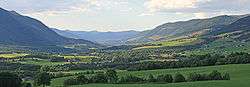
Dovre is a municipality in Oppland county, Norway. It is part of the traditional region of Gudbrandsdalen. The administrative centre of the municipality is the village of Dovre.

The municipality is bordered on the north by Oppdal municipality, on the east by Folldal, on the south by Sel and Vågå, and on the northwest by Lesja. The highest peak is Snøhetta at a height of 2,286 metres (7,500 ft). The municipality of Dovre was created when it was separated from the municipality of Lesja in 1861. The area "upper Folldal" was transferred from Dovre (and Oppland county) to Alvdal (and into Hedmark county) in 1884.
General information
Name
The municipality (originally the parish) is named after the old Dovre farm (Old Norse: Dofrar), since the first church was built here. The name is the plural of dofr, a word of unknown meaning. Other sites in Norway that have names beginning with Dovre- are commonly in the vicinity of clefts and gorges. In southern Sweden, the nature reserve Dovrasjödalen is the site of a wide gorge near Hallsberg in Örebro County, Sweden. [2]
Coat of arms
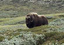
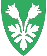
The coat of arms is from modern times. It was granted on 11 July 1986. The arms show a black muskox with a yellow horn on a gray background. The muskox is an animal typical for the northern parts of Canada, Alaska, and Greenland. It is not native to Norway, but in 1932, ten muskoxen were released near Dovre. The number has increased to around 300 today (2013), and the animal is thus a typical symbol for the municipality.[3]
| Ancestry | Number |
|---|---|
| 60 | |
| 30 | |
| 21 | |
| 20 | |
| 14 |
History
People have lived at Dovre for about 6,000 years. In the stone age, they were primarily hunters and fishermen. Approximately 2000 years ago, the first farms were developed at this location.
Dovre is mentioned in the Heimskringla (The Chronicle of the Kings of Norway) by Snorri Sturluson. In 1021, King Olaf laid hold of all the best men, both at Lesja and Dovre, and forced them either to receive Christianity or suffer death, if they were not so lucky as to escape.[5]
The Pilgrim's Route (Old King's Road) between Oslo and Trondheim in the 16th century passed through the Gudbrandsdal valley. After leaving the valley of the Lågen (downriver from present day Dombås) it passed over the Dovre Mountains into the present-day municipality. The heavy stream of annual pilgrims who visited the shrine of St. Olaf in Trondheim prior to the Reformation resulted in the erection of mountain stations where the pilgrims could find food and shelter. In speaking of this route, Gjerset quotes Peder Claussøn Friis as writing:
But in the winter people of high estate, as well as members of the court, travel mostly this way, because however high and deep the snow may fall, it blows together on the high mountains and becomes so hard men and horses can walk on it. The bonder run over it on ski and snowshoes. There are three stations: Drivstuen, Herdekinn, and Fogstuen built on this same mountain in order that travelers may find lodging there. …at the stations there are implements and dry wood, so that the traveler may build themselves fire, and not suffer from cold, when they have to remain over night, and cannot find the way across the mountain.[6]
The Battle of Kringen (Slaget ved Kringen) took place in August 1612, just downstream of Dovre, where the Scottish force stayed on 24 August 1612.
Churches

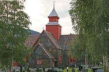
Dovre Church (Dovre kirke) was built in 1736. The bell tower was added early in the 19th century. It was built based upon designed by Jesper Mikkelson Rusten. It was constructed of wood and has protected status. [7]
Eystein Church (Eysteinskirka) in Dovre was built in 1969 as a church for pilgrims and travelers on the Pilgrim's Route. The church lies near the juncture of the boundaries of three counties; Hedmark, Oppland and Sør-Trøndelag. Eystein Church is built in concrete using stone and sand brought from the Hjerkinn. The plans for the church were designed by architect Magnus Poulsson (1881-1958).[8]
National Parks
Rondane National Park
Rondane National Park, which lies partially in Dovre, was the first Norwegian National Park, established on 21 December 1962. In 2003, Rondane National Park was enlarged and smaller areas of nature protection were opened or enlarged.
Dovre National Park
Dovre National Park lies primarily in Dovre, although part lies in Folldal in Hedmark. It was established in 2003. Dovre National Park covers an area of 289 square kilometres (112 sq mi) and the altitude varies from the tree line at 1,000 metres (3,281 ft) to the Folkstuhøe peak at 1,716 metres (5,630 ft). It is located between Rondane, which lies to its southeast, and Dovrefjell-Sunndalsfjella on its northwest.
Dovrefjell-Sunndalsfjella National Park
Dovrefjell-Sunndalsfjella National Park was founded in 2002 and encompasses part of the former Dovre National Park area (as founded in 1974). It is 1,693 square kilometres (654 sq mi) and encompasses areas in Dovre as well as in adjacent Lesja in Oppland and areas in Sør-Trøndelag and Møre og Romsdal. It includes the Dovrefjell mountain range.
Climate
The area is isolated from the sea and on fairly high altitude. The area has fairly little precipitation and has fairly cool summers and cold winters.
| Average for Dombås (645 m alt.)[9] | Jan | Feb | Mar | Apr | May | Jun | Jul | Aug | Sep | Oct | Nov | Dec | Year |
|---|---|---|---|---|---|---|---|---|---|---|---|---|---|
| Temperature (°C) | −9,4 | −8,2 | −4,3 | 0,3 | 6,5 | 10,7 | 12,0 | 11,1 | 6,6 | 2,2 | −4,3 | −7,7 | 1,3 |
| Precipitation (mm) | 33 | 25 | 23 | 14 | 27 | 51 | 57 | 49 | 40 | 43 | 35 | 33 | 430 |
Sister cities
The following cities are twinned with Dovre:[10]

Notable residents
- Ole Hjellemo (1873–1938), musician and composer
References
- ↑ "Navn på steder og personer: Innbyggjarnamn" (in Norwegian). Språkrådet. Retrieved 2015-12-01.
- ↑ "Dovrasjödalen". Visit Hallsberg. Retrieved April 1, 2018.
- ↑ Norske Kommunevåpen (1990). "Nye kommunevåbener i Norden". Retrieved 2008-12-30.
- ↑ "Immigrants and Norwegian-born to immigrant parents, by immigration category, country background and percentages of the population". ssb.no. Archived from the original on 2 July 2015. Retrieved 29 June 2015.
- ↑ Larson, Karen K. (1948). A History of Norway. Princeton University Press. ISBN 978-0-691-05127-7.
- ↑ Gjerset, Knut (1915). The History of the Norwegian People. New York: The MacMillan Company. ISBN 978-1-4326-3238-0.
- ↑ "Dovre kirke". Kunsthistorie. Retrieved April 1, 2018.
- ↑ "Eystein Church". National Pilgrim Center. Retrieved April 1, 2018.
- ↑ eklima.no Archived 2004-06-14 at the Wayback Machine.
- ↑ "Vennskapskommuner" (in Norwegian). Dovre kommune. Archived from the original (PDF) on 2011-06-10. Retrieved 2008-12-30.
External links
| Wikimedia Commons has media related to Dovre. |
| Look up Dovre in Wiktionary, the free dictionary. |
- Municipal fact sheet from Statistics Norway

- The Battle of Kringen
- Dovrenett
- Dovre Kommune (in Norwegian)
- Birdwatching Dovrefjell
- Skulpturstopp
|  | |||||||||||||||||||