Søndre Land
| Søndre Land kommune | |||
|---|---|---|---|
| Municipality | |||
 | |||
| |||
 Søndre Land within Oppland | |||
| Coordinates: 60°40′37″N 10°16′44″E / 60.67694°N 10.27889°ECoordinates: 60°40′37″N 10°16′44″E / 60.67694°N 10.27889°E | |||
| Country | Norway | ||
| County | Oppland | ||
| District | Land, Norway | ||
| Administrative centre | Hov | ||
| Government | |||
| • Mayor (2003) | Reidar Eriksen (Søndre Land Bygdeliste) | ||
| Area | |||
| • Total | 728 km2 (281 sq mi) | ||
| • Land | 659 km2 (254 sq mi) | ||
| Area rank | #150 in Norway | ||
| Population (2004) | |||
| • Total | 6,042 | ||
| • Rank | #165 in Norway | ||
| • Density | 9/km2 (20/sq mi) | ||
| • Change (10 years) | -3.7% | ||
| Demonym(s) | Søndrelending[1] | ||
| Time zone | UTC+01:00 (CET) | ||
| • Summer (DST) | UTC+02:00 (CEST) | ||
| ISO 3166 code | NO-0536 | ||
| Official language form | Bokmål | ||
| Website |
www | ||

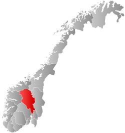
Søndre Land is a municipality in Oppland county, Norway. It is part of the traditional region of Land. The administrative centre of the municipality is the village of Hov.
The old municipality of Land was divided into Søndre Land and Nordre Land in 1847. The area of Fluberg was separated from Søndre Land to become a separate municipality on 1 January 1914, but it was merged back into Søndre Land on 1 January 1962.
General information
Name
The Old Norse form of the name was just Land which means "land". Therefore, the meaning of the name Søndre Land is "(the) southern (part of) Land". The parish and municipality of Land was divided in 1847.[2]
Coat-of-arms
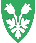
The coat-of-arms is from modern times. They were granted on 21 June 1985. The arms show three yellow tree trunks on a blue background. The blue colour of the shield symbolises the Randsfjorden, which borders the municipality. The tree trunks symbolise the importance of forestry and the sawmills in the municipality.[3]
| Ancestry | Number |
|---|---|
| 77 | |
| 57 | |
| 36 | |
| 32 | |
| 24 | |
| 22 | |
| 18 |
Geography
Søndre Land is bordered on the north by the municipality of Nordre Land, on the east by Gjøvik and Vestre Toten, on the west by Sør-Aurdal, and on the south by Gran in Oppland county. It is also bordered to the west by Ringerike in Buskerud county.
Søndre Land is 39.2 kilometres (24.4 mi) on a north-south axis and 31.3 kilometres (19.4 mi) east-west. It lies in the south of Oppland and on the northern end of Randsfjord. The highest elevation is Skjellinghovde with a height of 856 metres (2,808 ft). The main population centers include Holmen and Hov.
Notable residents
- Finn Thrana (1958–2006), lawyer
- Ola Skjølaas (1941-2006), politician
- Håvard Narum (born 1944), journalist
- Ola Viker (1897-1942), lawyer
- Martin Smeby (1891-1975), politician
- Jørgen Meinich (1820-1911), industrialist
- Christian Ancher (1711-1765), businessman
References
- ↑ "Navn på steder og personer: Innbyggjarnamn" (in Norwegian). Språkrådet. Retrieved 2015-12-01.
- ↑ Rygh, Oluf (1900). Norske gaardnavne: Kristians amt (Anden halvdel) (in Norwegian) (4 ed.). Kristiania, Norge: W. C. Fabritius & sønners bogtrikkeri. p. 179.
- ↑ Norske Kommunevåpen (1990). "Nye kommunevåbener i Norden". Retrieved 2009-01-01.
- ↑ "Immigrants and Norwegian-born to immigrant parents, by immigration category, country background and percentages of the population". ssb.no. Archived from the original on 15 July 2017. Retrieved 29 June 2015.
External links


- Municipal fact sheet from Statistics Norway

|  | |||||||||||||||||||