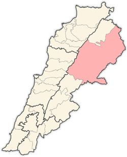
Duris, Lebanon
 Shown within Lebanon | |
| Alternative name |
Doris Douris |
|---|---|
| Location | 3 kilometres (1.9 mi) southwest of Baalbek, Lebanon |
| Coordinates | 33°59′00″N 36°11′00″E / 33.983333°N 36.183333°E |
| History | |
| Periods | Heavy Neolithic, Shepherd Neolithic, Roman |
| Cultures | Qaraoun culture |
| Site notes | |
| Excavation dates | 1957, 1966, 1997 |
| Archaeologists | M. Billaux, Henri Fleisch, Maurice Tallon, Lorraine Copeland |
| Public access | Unknown |

Duris, Dūris, or Dûris[2] (Arabic: دورس), formally Doris[3] and also known by its French spelling Douris,[4] is a village located approximately 3 km (2 mi). southwest of Baalbek in the Bekaa Valley, Lebanon. It is the site of a 13th-century Muslim shrine and a necropolis from the late Roman Imperial period that is currently undergoing archaeological investigation.[4]
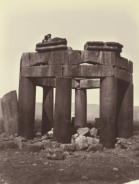
The Qubbat Duris was built in AD 1243 (AH 641)[5] during the Ayyubid era.[4] Its sarcophagus was raised or left standing to serve as a mihrab, helping to direct prayer towards Mecca.[1] Its columns were probably removed from the ruins of nearby Baalbek and are assembled haphazardly, one being upside-down.[6]
Another archaeological site which is not on the tell near the village exists 1 km (1 mi) southwest of Duris at the north of a vineyard that can be reached via a track from the road to Baalbek. This site was found to contain both Shepherd Neolithic and Heavy Neolithic material together, being unusual in this respect. It was found by M. Billaux in 1957 who showed it to two archaeologists who were also members of the Society of Jesus, Henri Fleisch and Maurice Tallon. The Shepherd Neolithic material was unpatinated and appeared similar to that of Maakne. The larger pieces were patinated to white, appearing to represent different periods. Three Levallois flakes were found in 1966 by Lorraine Copeland.[7]
Modern site
Due to urban expansion, the area is now inhabited by 14,000 people.
Notable people
- Nadine Nassib Njeim, Actress and Miss Lebanon 2004
See also
References
Citations
- 1 2 Jessup (1881), p. 452.
- ↑ Robinson (1856), p. 504.
- ↑ "Doris Municipality", Baalbeck Municipalities Union .
- 1 2 3 "Late Antique Necropolis in Baalbek Douris (Lebanon)", Deutsches Archäologisches Institut, Berlin: German Archaeological Institute, 2015 .
- ↑ Jamil (1948), p. 281.
- ↑ De Saulcy (1853), p. 639.
- ↑ L. Copeland; P. Wescombe (1966). Inventory of Stone-Age Sites in Lebanon: North, South and East-Central Lebanon, pp. 29-30. Impr. Catholique. Retrieved 29 August 2011.
Bibliography
- De Saulcy, Louis Félicien J. Caignart (1853), Narrative of a Journey round the Dead Sea and in the Bible Lands in 1850 and 1851, Vol. II, London: Bradbury & Evans for Richard Bentley .
- Jamil, Rouhi (1948), Beirut and the Republic of Lebanon, The Green Guides, Librairie Universelle .
- Jessup, Samuel (1881), "The Wady Barada", Picturesque Palestine, Sinai, and Egypt, Division II, New York: D. Appleton & Co, pp. 444–452 .
- Robinson, Edward (1856), Later Biblical Researches in Palestine, and in the Adjacent Regions. A Journal of Travels in the Year 1852 by E. Robinson, E. Smith, and Others, Boston: Crocker & Brewster .
- Serraine Et Tahta, Localiban
Capital: Baalbek | ||
| Towns and villages |
|  |
| Other | ||