Moorreesburg
| Moorreesburg | |
|---|---|
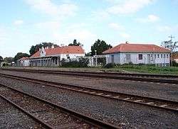 Moorreesburg railway station | |
 Moorreesburg  Moorreesburg Moorreesburg (South Africa)  Moorreesburg Moorreesburg (Africa) | |
| Coordinates: 33°09′S 18°40′E / 33.150°S 18.667°ECoordinates: 33°09′S 18°40′E / 33.150°S 18.667°E | |
| Country | South Africa |
| Province | Western Cape |
| District | West Coast |
| Municipality | Swartland |
| Established | 1882[1] |
| Area[2] | |
| • Total | 27.8 km2 (10.7 sq mi) |
| Population (2011)[2] | |
| • Total | 12,877 |
| • Density | 460/km2 (1,200/sq mi) |
| Racial makeup (2011)[2] | |
| • Black African | 6.7% |
| • Coloured | 70.1% |
| • Indian/Asian | 0.2% |
| • White | 22.5% |
| • Other | 0.4% |
| First languages (2011)[2] | |
| • Afrikaans | 92.0% |
| • Xhosa | 3.5% |
| • English | 2.2% |
| • Other | 2.3% |
| Time zone | UTC+2 (SAST) |
| Postal code (street) | 7310 |
| PO box | 7310 |
| Area code | 022 |
Moorreesburg is a rural town situated about 90 kilometres (60 mi) north of Cape Town, in the Western Cape province of South Africa. It was laid out in 1879 on the farm Hooikraal, was administered by a village management board from 1882 and attained municipal status in 1909. Today it falls within the Swartland Local Municipality, which is part of the West Coast District Municipality. Moorreesburg was named after J.C. le Febre Moorrees (1807–1885), minister of the Swartland congregation of the Nederduitse Gereformeerde Kerk from 1833 to 1881.[3]
According to the 2011 census, Moorreesburg has a population of 12,877 people in 3,698 households. 70% of the population identified themselves as "Coloured", while 23% identified as "White" and 7% as "Black". 92% spoke Afrikaans as their first language, while 3% spoke Xhosa and 2% spoke English.[2]
Mooreesburg lies just off the N7 national road, at a driving distance of 100 kilometres (62 mi) from Cape Town. The R311 regional road also passes through the town, as does the West Coast branch line railway. It has two public primary schools, one public high school, a library, a police station, a magistrate's court, and a health clinic.
References
- ↑ "Chronological order of town establishment in South Africa based on Floyd (1960:20-26)" (PDF). pp. xlv–lii.
- 1 2 3 4 5 Sum of the Main Places Moorreesburg and Rosenhof from Census 2011.
- ↑ "Dictionary of Southern African Place Names (Public Domain)". Human Science Research Council. p. 315.
| Wikivoyage has a travel guide for Moorreesburg. |
Municipalities and communities of West Coast District Municipality, Western Cape | ||
|---|---|---|
District seat: Moorreesburg | ||
| Matzikama | .svg.png) | |
| Cederberg | ||
| Bergrivier | ||
| Saldanha Bay | ||
| Swartland | ||