List of districts of Arunachal Pradesh
Arunachal Pradesh state of India consists of 22 districts, with more districts proposed and in development.
History
When control of the North-East Frontier Agency was transferred to the Ministry of Home Affairs in September 1965 its five divisions, Kameng, Subansiri, Siang, Lohit and Tirap each became districts.
Over the next few years many new districts were created out of the original five:
- On 13 May 1980 Subansiri district was bifurcated into two districts: Lower Subansiri district and Upper Subansiri district. Upper Subansiri district comprised the area occupied by the erstwhile Daporijo sub-division and Lower Subansiri district comprised the rest of the area occupied by the erstwhile Subansiri district.[1]
- On 1 June 1980, the erstwhile Lohit district was divided into two districts: Lohit district and Dibang Valley district.[2]On the same day, Siang district was bifurcated into two districts: East Siang district and West Siang district.[3]Also on that date Seppa and Bomdila sub-divisions of the Kameng district were transformed into East Kameng district and West Kameng district, respectively.[4][5]
- On 6 October 1984, Tawang district was separated from East Kameng district.[6]
- In 1987, the ersthwile Tirap district was divided into two districts: Tirap district and Changlang district.[7]
- On 22 September 1992, the erstwhile Lower Subansiri district was again bufurcated into Lower Subansiri district and Papum Pare district.[8]
- In 23 November 1994, Upper Siang district was split from East Siang district.[9]
- On 1 April 2001, Kurung Kumey district was carved out from the erstwhile Lower Subansiri district.[10]
- On 16 December 2001, Dibang Valley district was bifurcated into Upper Dibang Valley district and Lower Dibang Valley district.[2]
- On 16 February 2004, Anjaw district was carved out from the erstwhile Lohit district.[11]
- On 19 March 2012, Longding district was carved out from the erstwhile Tirap district.[12]
- On 25 November 2014, Namsai district was carved out from the erstwhile Lohit district.[13]
- On 7 February 2015, Kra Daadi district was carved out from the erstwhile Kurung Kumey district.[14]
- On 27 November 2015, a new Siang district was carved out from parts of East Siang and West Siang districts.[15]
- On 22 September 2017, Lower Siang district, was carved out of West Siang and East Siang districts.[16][17][18]
- On 4 December 2017, a new district called Kamle district was created from Lower Subansiri District and Upper Subansiri District, with its headquarters to be located in Raga.[19] It comprises the administrative circles of Raga (which will be the district HQ), Kumporijo and Dollungmukh circles from Lower Subansiri District.[20] The administrative circles taken from Upper Subansiri District will be Gepen Circle, Puchigeko Circle, Daporijo Sadar which falls under 25 Raga Constituency including Ligu and Liruk demarcation from Sigen Subansiri confluence in Single Administrative Unit.
- On 30 August 2018, 3 new districts, Pakke-Kesang, Lepa Rada and Shi Yomi formed. The Pakke-Kessang district will be carved out of East Kameng district with five administrative units namely Pakke-Kessangn, Seijosa, Pijiriang, Passa Valley and Dissingn Passo with district headquarters at Lemmi. The Lepa Rada district would be created by bifurcating the Lower Siang district with headquarters at Basar. The district would have four administrative units Tirbin, Basar, Daring and Sago. The Shi-Yomi district would be created by bifurcating the West Siang district with its headquarters at Tato. The district would have four administrative units namely Mechuka, Tato, Pidi and Manigong.[21]
Administrative set-up
The districts of Arunachal Pradesh state are administrative geographical units, each headed by a deputy commissioner, an officer belonging to the Indian Administrative Service and a superintendent of police, an officer belonging to the Indian Police Service.
Districts
As of August 2018, Arunachal Pradesh comprises 25 districts. Although Itanagar capital complex does not have district status it is counted by some as one (making the district count 26 now).[22] Most of the districts are inhabited by various tribal groups. These are:[23]
| Code | District | Headquarters | Population (2011)[24] | Area (km²) | Density (/km²) | Map | Year created |
|---|---|---|---|---|---|---|---|
| TA | Tawang | Tawang Town | 49,950 | 2,085 | 19 | 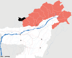 | 1984 |
| WK | West Kameng | Bomdila | 87,013 | 7,422 | 10 | 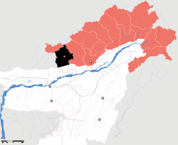 | 1980 |
| EK | East Kameng | Seppa | 78,413 | 4,134 | 14 | 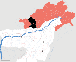 | 1980 |
| Pakke-Kessang district | Lemmi | 2018 | |||||
| PA | Papum Pare | Yupia | 176,385 | 2,875 | 42 | 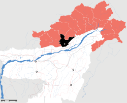 | 1992 |
| Kurung Kumey | Koloriang | 89,717 | 8,818 | 10 | 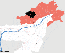 | 2001 | |
| Kra Daadi | Jamin | 2015 | |||||
| LB | Lower Subansiri | Ziro | 82,839 | 3,460 | 24 | 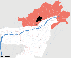 | 1980 |
| UB | Upper Subansiri | Daporijo | 83,205 | 7,032 | 8 | 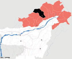 | 1980 |
| WS | West Siang | Along | 112,272 | 8,325 | 12 | 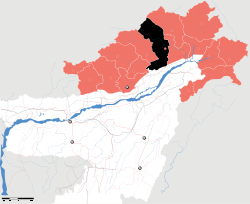 | 1980 |
| Shi-Yomi District | Tato | 2018 | |||||
| ES | East Siang | Pasighat | 99,019 | 4,005 | 22 | 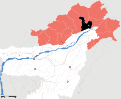 | 1980 |
| Siang | Pangin | 2015 | |||||
| US | Upper Siang | Yingkiong | 33,146 | 6,188 | 5 | 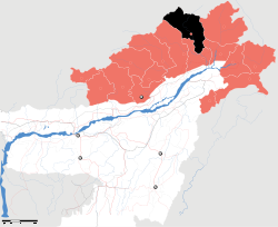 | 1994 |
| Lower Siang | Likabali | 2017 | |||||
| Lepa-Rada District | Basar | 2018 | |||||
| UD | Lower Dibang Valley | Roing | 53,986 | 3,900 | 14 | 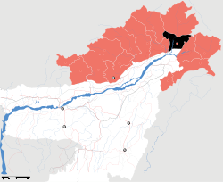 | 2001 |
| Upper Dibang Valley | Anini | 7,948 | 9,129 | 1 | 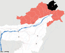 | 2001 | |
| AJ | Anjaw | Hawai | 21,089 | 6,190 | 3 |  | 2004 |
| EL | Lohit | Tezu | 145,538 | 2,402 | 13 |  | 1980 |
| Namsai | Namsai | 2014 | |||||
| CH | Changlang | Changlang | 147,951 | 4,662 | 27 |  | 1987 |
| TI | Tirap | Khonsa | 111,997 | 2,362 | 42 |  | 1965 |
| LD | Longding | Longding | [25] | [25] | [25] | [25] | 2012 |
| Kamle | Raga | 22,256[19] | 2017 |
Proposals for new districts
- In January 2013, a Capital district, within Papum Pare district, including sub-divisions of Banderdava, Itanagar, and Naharlagun was proposed.[16]
- In February 2017, a "Rima district" with HQ at Miao, having districts Diyun, Bordumsa, Kharsang, Jairampur, Nampong, Rima-Putak (Tikhak), Miao, and Vijoynagar from Changlang district was proposed. However it was unanimously opposed by the Changlang People's Forum in the same month.[26][27]
- Sagalee district, from Papum Pare district. Sub-divisions: Sagalee, Leporiang, Parang, and Mengio.
- "North Subansiri district", from Kurung Kumey (Sub-divisions of Sarli, Damin), Kra Daadi (Sub-division of Pipsorang/Longding Koling) and Upper Subansiri (Sub-divisions of Taksing, Limeking, Nacho, Siyum) districts.
- "Leparada district" with headquarter in Basar.
- "Hayuliang district", from Anjaw district (Sub-divisions of Hayuliang, Metengliang, Chaglagam, Goiliang) and northeastern parts of Tezu circle in Lohit district.
- "Pakke-Kesang district", given approval to proceed by the state government in May 2017.[28][29]
Notes
- ↑ "District Census Handbook, Lower Subansiri" (PDF). Government of India. 16 June 2014.
- 1 2 "District Census Handbook, Lower Dibang Valley" (PDF). Government of India. 16 June 2014. p. xix.
- ↑ "District Census Handbook, East Siang" (PDF). Government of India. 16 June 2014. p. 8.
- ↑ "District Census Handbook, East Kameng" (PDF). Government of India. 16 June 2014. p. 8.
- ↑ "District Census Handbook, West Kameng" (PDF). Government of India. 16 June 2014. p. 8.
- ↑ "District Census Handbook, Tawang District" (PDF). Government of India. 16 June 2014. p. 8.
- ↑ "District Census Handbook, Changlang" (PDF). Government of India. 16 June 2014. p. 8.
- ↑ "District Census Handbook, Papum Pare" (PDF). Government of India. 16 June 2014. p. 8.
- ↑ "District Census Handbook, Upper Siang" (PDF). Government of India. 16 June 2014. p. 8.
- ↑ "District Census Handbook, Kurung Kumey" (PDF). Government of India. 16 June 2014. p. 8.
- ↑ "District Census Handbook, Anjaw" (PDF). Government of India. 16 June 2014. p. 8.
- ↑ Gwillim, Law (2016). "India Districts". www.statoids.com.
- ↑ "Namsai became the 18th district of Arunachal Pradesh in November 2014". India Today. December 18, 2014. Retrieved 26 October 2015.
- ↑ "Arunachal Pradesh carves out new district". The Times of India. 9 February 2015.
- ↑ "Siang becomes 21st district of Arunachal". The Arunachal Times. 28 November 2015.
- 1 2 "Arunachal to get four new districts". timesofindia. 2013-01-16. Retrieved 2013-01-16.
- ↑ Lepcha, Damien (23 September 2017). "Lower Siang starts functioning". The Telegraph India.
- ↑ "Khandu Cabinet approves Operation of Lower Siang District with HQ Likabali". Arunachal24.in. 22 September 2017.
- 1 2 "Protect tribals if Chakma & Hajong are considered for citizenship, says legislative assembly". arunachaltimes.in. 19 October 2017.
- ↑ "Arunachal Assembly approves Kamle as 23rd district of state". Arunachal24.in. 18 October 2017.
- ↑ "Arunachal Assembly Passes Bill For Creation Of 3 New Districts". NDTV.com. Retrieved 2018-08-30.
- ↑ "Arunachal Assembly approves Kamle as 23rd district of state". Arunachal24.in. 18 October 2017.
- ↑ "State Profile of Arunachal Pradesh" (PDF). Ministry of Micro, Small and Medium Enterprises, Government of India. 2014. pp. 12–15.
- ↑ "District Census 2011". Census2011.co.in.
- 1 2 3 4 Longding is included as part of Tirap
- ↑ Zauing, Pisi (11 February 2017). "Consensus reached on creation of new district". The Arunachal Times.
- ↑ "Civil society opposes creation of proposed Namdapha/Rima dist". The Arunachal Times. 18 February 2017.
- ↑ "Kamle dist this year, Go-ahead for Pakke-Kesang dist- Khandu". Arunachal24.in. 25 May 2017.
- ↑ "Normal Pages" (PDF). The Hills Times. 21 October 2017.
| States | ||
|---|---|---|
| Union Territories | ||
| Related topics | ||