Yingkiong
| Yingkiong | |
|---|---|
| Town | |
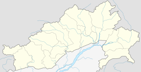 Yingkiong Location in Arunachal Pradesh, India  Yingkiong Yingkiong (India) | |
| Coordinates: 28°36′37″N 95°02′51″E / 28.61037°N 95.047531°ECoordinates: 28°36′37″N 95°02′51″E / 28.61037°N 95.047531°E | |
| Country |
|
| State | Arunachal Pradesh |
| Elevation | 200 m (700 ft) |
| Population (2011 Census) | |
| • Total | 8,573 |
| Time zone | UTC+5:30 (IST) |
| Vehicle registration | AR-14 |
| Website | https://uppersiang.nic.in/ |
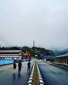
Yingkiong is the headquarter of the Upper Siang district in the state of Arunachal Pradesh in India.[1] A small town that lies east of Arunachal Pradesh. It is situated at an elevation of 200 meters (700 ft)above sea level, and sits adjacent to Siang river or Yarlung Zangbo of Tibet on its west ,The Town has a population of 8573 persons as of ( 2011 census).[2]
History
Prior to 1995, the district of Upper siang was a part of East Siang district,It was bifurcated from East Siang in the same year[3]. The administrative district (Upper Siang) where the town sits dates back to time when Arunachal Pradesh was an Independent region.Until the Anglo-Burmese war of 1826-1861 the state was not under any administrative control of the Britishers or any other Government after the war and subsequent treaty of Yandaboo in Burma, entire North-Eastern state along with the administrative district and its headquarter was declared conquered by British.however,in practice, British control did not actually extend till the area ,It was only up to Pasighat town in East Siang that in 1911 AD and subsequent Anglo-Abor wars that British included this region under its administrative control.It fell under the administrative control of the Assistant Political Officer stationed at Sadiya in Assam during the period[4]
Geography
Yingkiong is located at coordinates 28.61037°N 95.047531°E,The town sits at an elevation of 200 meters(700 ft) above sea level,adjacent to its west flows Siang river known by different names Yarlung Zangbo in Tibet and Brahmaputra in Assam region.[5] It is bounded by Tibet region on the North, Dibang valley in the East, to its west lies west Siang district and East Siang District in the South.[6] The Town is surrounded by hills on almost all side except for Siang on the west, and the area present a challenging topography characterized by frequent landslide and roadblocks[7]
Climate
The region is characterised by relatively warm subtropical climate with highest recorded temperature at 25 degrees in Summer and 8 degrees in winter.[8] and it is relatively humid.The region receives annual rainfall of 3240 mm.[9] The upper regions receives snow falls almost throughout the year.
Economy
Agriculture is the main occupation,and a major source of livelihood,Rice ,Maize and Millet constitutes the principal food crop.besides agriculture vegetable cultivation and sale at the daily market,crafts making like cane and bamboo murha constitutes another major economic activities.Fruit cultivation like orange,pineapple are common and are sold at daily market or outside the region like Pasighat.Adi people produces type of basket that they suspend through a cane rope on their head used for carrying daily items of usage like rice ,dried woods called 'Egin' locally,[10] is also a major craft products produced locally and sold to natives.A variety of Black and Red Tea called Siang Tea [11] is also produced for export in the Moying Tea Factory.
Demography
As of 2011 census of the Ministry of Home Affairs,Government of India,the town has a total population of 8573 persons. Male population of 4,381 and Female 4,192 ,with 1,139 persons under the age group of 0 to 6 ,total working population of 3,787 persons,with males working population of 2,221 and female constitutes 1,566 workers.[12] Literacy rate of the region is 79.17% above state average of 65.38% of which female literacy rate 73.96% and Male literacy of 84.10%.[13] It has a non-working population of 4,786 persons mostly(dependent age). Adi is the language spoken in the area. Hindi finds prominence due to its importance as a Lingua Franca to communicate with people who do not speak Adi.
Religion
Religion wise population distribution as of 2001 Census - Yingkiong
| Total Population | Hinduism | Islam | Christianity | Sikhism | Buddhist | Jain | Donyi-Polo | Not Stated | |
| Total Population | 6,540 | 2,028 | 198 | 1,061 | 4 | 117 | 0 | 3,075 | 57 |
Festivals
The locals of Yingkiong celebrates Solung,[14] Aran(Unying-Aran) and Etor,Siang River Festivals and Mopin festivals.
- Solung a festival celebrated for agriculture and harvest,prevalent among the Adi community are various myths, stories, faiths and beliefs about the origin of the ‘Solung’ festivity.Generally celebrated mid August–September,The date for the festival is fixed by the village council called 'Kebang' . Sometimes, even the ‘Gam’ (village headman) fixes the date of this festival on consultation with other leaders of the village. On the day, villagers begins preparing the ‘rice-beer’ or ‘Apong’. Fresh vegetables and plenty of meats are also stored for the occasion.
- Aran(Unying Aran) A new year festival of the Adi community celebrated in East and Upper Siang,[15] marking the arrival of the spring season,during this male elders of the village performs Bari dance and young boys and girls performs Yakjong dance and through the dance narrate stories of origin of the festival and also pray for good health and prosperity of people.
- Etor celebrated on May 15 by Adi tribes of East and Upper Siang,and Etor literally means 'a fence' huge feast and offerings are made to gods and is celebrated to begin the annual agricultural cycle of the community[16]
- Siang River Festival Earlier known as Brahmaputra Darshan Festival,Later change its name to Siang River Festival after 2005,Yingkiong,Tuting and Pasighat were chosen as the places to conduct this festival of Communal Harmony.[17]
Connectivity
The town is connected to the rest of the country and Arunachal Pradesh via National Highway 513(NH-513) and NH-52 from Pasighat to Itanagar via regular bus and Tata sumo services.There is no direct Air connectivity and was earlier limited to Dibrugarh Airport [18] and in 2018 new airline services opened up in Pasighat[19] which is the nearest airport to reach Yingkiong. Helicopter services can be availed from Pasighat,Itanagar,Assam to reach the town,[20] there are two heliports in the town,one near the Siang and other opposite the District Collectorate that facilitates helicopter services.[21] The nearest Railway station is in Murkongselek in Jonai District of Assam[22] to connect Yingkiong town via Pasighat[23]
Tourism
Notable tourist spots in and around the town:—
- Jengging-Yingkiong Circuit situated at a distance of approximately 20 kilometres, a trekking site and a small town, adjacent to Siang across Yingkiong town, this town in Upper siang provides views of Siang from other end of the town
- Mouling National Park Another prominent national park of Arunachal Pradesh created in 1986 after Namdapha National Park of 1983[24], has abundant Flora and Fauna.[25] Animals of this National Park include Red Panda, Deer, Hoolock Gibbons and Tiger,wild buffalo, panther, elephant, hog dear, barking deer, sambar, python.[26]
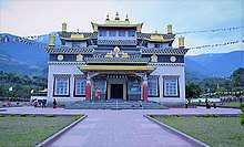
- Tuting Gompa/Monastery A sacred Buddhist site,from a distance of around 300 kilometres from Headquarter Yingkiong towards the North,[27] it can be reached via regular Tata sumo services and bi-weekly helicopter services to Tuting Airport from Itanagar via Yingkiong.
- Tuting-Geling Singha They together constitutes the “Pemako Zone” of the Tibetan form of Buddhism,that lies amidst natural lakes.These tourist spots are very close to Indo-China border
- Gandhi Bridge bridge over river Siang [28] made of cane [29] on way to Tuting and Moying is another tourist attraction.
Notable people
- Gegong Apang longest serving Chief Minister of Arunachal Pradesh for 22 Years [30],and Third in India after Pawan Kumar Chamling of Sikkim[31] and Jyoti Basu of West Bengal as of 2018.[32]
- Alo Libang present Deputy Speaker of Arunachal Legislative Assembly.[33]
- Apur Bitin IPS(Indian Police Service) DIG,Eastern Range ,Arunachal Pradesh.[34]
- Kishon Tekseng Everest Mountaineer
- Ojing Dameng -IRS (Indian Revenue Service )[35]
References
- ↑ "Upper Siang | Arunachal Pradesh | DISTRICTS OF INDIA". districts.nic.in. Retrieved 2018-09-19.
- ↑ 2011, Yingkiong. "Census ,Govt of India".
- ↑ http://dcmsme.gov.in/dips/Dist-Profile-Upper-Siang.pdf
- ↑ "PASIGHAT". PASIGHAT-The land of rising sun. 2011-05-12. Retrieved 2018-09-21.
- ↑ "Brahmaputra/Yarlung Tsangpo". International Rivers. Retrieved 2018-09-19.
- ↑ "About District | District Upper Siang, Government of Arunachal Pradesh". uppersiang.nic.in. Retrieved 2018-09-19.
- ↑ Tribune, India. "Flood,Landslides wreak havoc in Arunachal".
- ↑ "Best Time to Visit Yingkiong, Arunachal Pradesh | Weather Information". www.tourmyindia.com. Retrieved 2018-09-19.
- ↑ "Yingkiong Notified Town". indikosh.com. Retrieved 2018-09-19.
- ↑ Sharma, Tika Prasad (October 2008). "Ethnobotanical observations on Bamboos among Adi tribes in Arunachal Pradesh". Indian Journal of Traditional Knowledge. 7 (4): 594–597 – via Department of Botany, Gauhati University, Guwahati 781014, Assam.
- ↑ "SIANG TEA AND INDUSTRIES PVT LTD - Company, directors and contact details | Zauba Corp". www.zaubacorp.com. Retrieved 2018-09-19.
- ↑ "Census of India: Primary Census Abstract". censusindia.gov.in. Retrieved 2018-09-19.
- ↑ "Yingkiong City Population Census 2011 - Arunachal Pradesh". www.census2011.co.in. Retrieved 2018-09-19.
- ↑ "CS visits Upper Siang, attends Solung festival | The Arunachal Times". arunachaltimes.in. Retrieved 2018-09-19.
- ↑ "Unying Aran celebrated with traditional fervor | The Arunachal Times". arunachaltimes.in. Retrieved 2018-09-19.
- ↑ "Significance of Aran Festival for Rodent Management by Adi Tribes of Arunachal Pradesh". Journal of Global Communication. 9 (1). 2016. ISSN 0974-0600.
- ↑ "Famous Festivals Of Arunachal Pradesh". Nelive. 2018-07-04. Retrieved 2018-09-19.
- ↑ "How to Reach Yingkiong, Arunachal | By Road, Train & Air | Tourism". www.tourmyindia.com. Retrieved 2018-09-19.
- ↑ "Arunachal's first commercial flight lands at Pasighat airport - Times of India". The Times of India. Retrieved 2018-09-19.
- ↑ "Civil Aviation – Government of Arunachal Pradesh". www.arunachalpradesh.gov.in. Retrieved 2018-09-19.
- ↑ "Google Maps". Google Maps. Retrieved 2018-09-19.
- ↑ Shah, Jay. "Murkongselek Station - 3 Train Departures NFR/Northeast Frontier Zone - Railway Enquiry". indiarailinfo.com. Retrieved 2018-09-20.
- ↑ Trade, TI. "The Assam Tribune Online". www.assamtribune.com. Retrieved 2018-09-20.
- ↑ "Namdapha National Park | Changlang District, Government of Arunachal Pradesh". changlang.nic.in. Retrieved 2018-10-14.
- ↑ "Mouling National Park | District Upper Siang, Government of Arunachal Pradesh". uppersiang.nic.in. Retrieved 2018-10-14.
- ↑ "Mouling National Park - complete detail - updated". NatureConservation.in. 2018-09-12. Retrieved 2018-09-19.
- ↑ "Tuting". Times of India Travel. Retrieved 2018-09-19.
- ↑ "Gandhi Bridge speeded up to become functional soon | Arunachal Observer". Arunachal Observer. 2017-11-23. Retrieved 2018-09-20.
- ↑ "The Governor of Arunachal Pradesh :: Governor on Gandhi Bridge". arunachalgovernor.nic.in. Retrieved 2018-09-20.
- ↑ "Congress leader Gegong Apang joins BJP". The Hindu. PTI. 2014-02-20. ISSN 0971-751X. Retrieved 2018-09-20.
- ↑ Desk, The Hindu Net (2018-04-29). "Pawan Kumar Chamling crosses Jyoti Basu's record as longest-serving Chief Minister". The Hindu. ISSN 0971-751X. Retrieved 2018-09-20.
- ↑ "Top 5 longest serving Chief Ministers in India". Jagran Post. Retrieved 2018-09-20.
- ↑ "Alo Libang elected Arunachal deputy speaker - Times of India". The Times of India. Retrieved 2018-09-20.
- ↑ "PressReader.com - Connecting People Through News". www.pressreader.com. Retrieved 2018-09-21.
- ↑ https://dopt.gov.in/sites/default/files/UPSC%20WEB%203rd%20list%20.pdf