Roing
| Roing | |
|---|---|
| Town | |
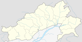 Roing Location in Arunachal Pradesh, India  Roing Roing (India) | |
| Coordinates: 28°8′34″N 95°50′34″E / 28.14278°N 95.84278°ECoordinates: 28°8′34″N 95°50′34″E / 28.14278°N 95.84278°E | |
| Country |
|
| State | Arunachal Pradesh |
| District | Lower Dibang Valley |
| Population (2011) | |
| • Total | 11,389 |
| Languages | |
| • Official | English |
| Time zone | UTC+5:30 (IST) |
| ISO 3166 code | IN-AR |
| Vehicle registration | AR-16 |
| Climate | Cwa |
Roing is a district headquarter of Lower Dibang Valley district in the Indian state of Arunachal Pradesh. It is the last major township at the north-eastern frontier of India.
Demographics
As of 2011 India census,[1] Roing had a population of 11,389 of which 6,064 are males while 5,325 are females. Roing has an average literacy rate of 88.39%, higher than the national average of 65.38%: male literacy is 91.94%, and female literacy is 84.35%. Population of Children with age of 0-6 is 1157 which is 10.16 % of total population of Roing.
Female Sex Ratio is of 878 against state average of 938. Moreover Child Sex Ratio in Roing is around 875 compared to Arunachal Pradesh state average of 972.
Roing has total administration over 2,617 houses to which it supplies basic amenities like water and sewerage.
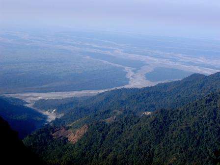
Both Mishmi (Idu) and Adi form the principal indigenous dwellers of Roing. Mehao wild life sanctuary, Sally lake, Mehao lake and Mayudia mountain pass remain covered with snow during peak winter. The town, located at the foothill of the Mishmi Hill, is lively with friendly people. Reh festival of Mishmi (Idu) is celebrated in the month of 1 February while Solung festival of Adi in 1 September every year with great joy. Towards the north flows the river Eze that swells in summer causing a great concern to the town's future. Bridges over it had been repeatedly washed away draining Government's exchequer. Towards the south and east are the villages of Adi and Mishmi (Idu) that extend to Assamese border. The town is the only commercial centre for both Upper and Lower Dibang Valley Districts.
Unlike other rough terrain towns of Arunachal, Roing is quite plain with a lot of land for farming and cultivation.
It is one of the 60 constituencies of Legislative Assembly of Arunachal Pradesh. Name of current MLA (August-2016) of Roing constituency is Mutchu Mithi.[2]
Transport
Roing is connected to Tinsukia, a major town of Assam, separated by the Brahmaputra river which is the major route. During summer the river floods which takes a three-hour journey via ferry-boat which is quite an experience to have. The recently inaugurated Dhola-Sadiya bridge had made the route to Roing much easier one. Another route is via Tezu-Chowkham-Namsai again connecting to Tinsukia which is an all season road link due to the bridge over Lohit at Parshuram Kund and another one at Namsai.
Road
Bus Routes Operated by APSTS, Roing and Private Transport Services:
- Roing – Tezu
- Roing – Sadiaghat
- Roing – Hunli
- Roing – Dello
- Roing – Rukmo
- Roing – Koronu
- Roing – Chidu
- Roing – Old Abali
- Roing – Balek
- Roing – Tinsukia
- Roing – Anini (Tata Sumo)
- Dambuk - Paglam
Railway
Nearest Railway Station:
- Dhangiri (60 km Approx.)
Airport
Nearest Airport:
- Chabua (138 km Approx.)
- Mohanbari(Dibrugarh) (148 km Approx.)
- Guwahati (500 km Approx.)
Bazaar
The Roing Bazaar is the market where most residents buy and sell supplies and food. The proposed highway of the Special Accelerated Road Development Programme (SARDP) will run through the bazaar, possibly increasing customers.
Media
Roing has an All India Radio Relay station known as Akashvani Roing. It broadcasts on FM frequencies,The town also offers a few local newspaper i.e Downlit post,The Roing Times.
References
- ↑ "Census of India 2001: Data from the 2001 Census, including cities, villages and towns (Provisional)". Census Commission of India. Archived from the original on 2004-06-16. Retrieved 2008-11-01.
- ↑ "Roing MLA". Archived from the original on 19 August 2016. Retrieved 14 August 2016.
External links
- Trip To Roing
- India travel portal
- Eastern Arunachal tribal tour
- http://www.helptourism.com for birding tours and cultural tours.Help Tourism and a local Mishmi family have jointly developed Dibang Valley Jungle Camp, 12th Mile, Roing.For information contact: info@helptourism.com.
- http://www.thegreenerpastures.com - Greener Pastures is an Eco-tourism organization which provides responsible tours to offbeat destinations in Northeast India.