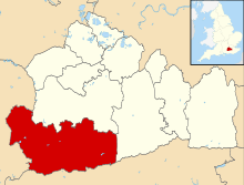
Devil's Punch Bowl
The Devil's Punch Bowl is a large natural amphitheatre and beauty spot near Hindhead, Surrey, in England, and is the source of many stories about the area. The London to Portsmouth road (the A3) skirted the centre of the site before the Hindhead Tunnel was built in 2011.[1]
The land is now owned and maintained by the National Trust as part of the "Hindhead Commons and the Devil's Punch Bowl" property. A Youth Hostel Association youth hostel used to be located inside the bowl but has now closed down. The highest point is Gibbet Hill at 272 metres (892 ft) AOD.
Etymology
The name Devil's Punch Bowl dates from at least 1768, the year that John Rocque's map of the area was published. This was 18 years before the murder of the unknown sailor on Gibbet Hill, so this event was clearly not the origin of the name. Prior to 1768, it was marked as "ye Bottom" on a map by John Ogilby dated 1675. The northern end of the Bowl is known as Highcombe Bottom which exists in different variants: Hackombe Bottom,[2] Hacham Bottom,[3] and Hackham Bottom.[4] These variants suggest that the pronunciation of the name is "Hay-combe" rather than "High-combe".
Natural history
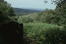
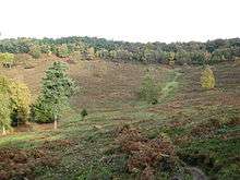
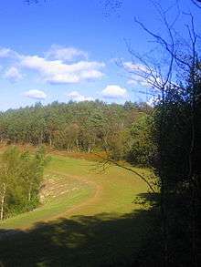
The soil in this part of Surrey has two layers — an upper layer of sandstone, with clay beneath. This deep depression is believed to be the result of erosion caused by spring water beneath the sandstone, causing the upper level to collapse. With its steep sides, the Devil's Punch Bowl has become a natural nature reserve, filled with heathland, streams and woodland.
The site has abundant wildlife. Most woodland species can be seen easily - including lesser spotted woodpecker and redstart. It is known for being the last remaining locality of wood warbler in Surrey.
Local legends
Local legend has colourful theories as to its creation. According to one story, the Devil became so irritated by all the churches being built in Sussex during the Middle Ages that he decided to dig a channel from the English Channel through the South Downs and flood the area. As he began digging, he threw up huge lumps of earth, each of which became a local landmark — such as Chanctonbury Ring, Cissbury Ring and Mount Caburn. He got as far as the village of Poynings (an area known as the Devil's Dyke) when he was disturbed by a cock crowing. (One version of this story claims that it was the prayers of St Dunstan that made all the local cocks crow earlier than usual.) The devil assumed that dawn was about to break and leapt into Surrey, creating the Devil's Punch Bowl where he landed.
Another story goes that, in his spare time, he hurled lumps of earth at the god Thor to annoy him. The hollow out of which he scooped the earth became the Punch Bowl. The local village of Thursley means Thor's place.[5] An alternative version of this story says that Thor threw the earth at the Devil, who was annoying Thor by jumping across the Devil's Jumps.
A still older story claims that two giants clashed in the area, and one scooped up earth to throw at the other, creating the landmark before missing the throw and creating the Isle of Wight.
Development and protected status
The beauty of the area and the diversity of nature it attracts that has gained the Devil's Punch Bowl the title of a Site of Special Scientific Interest. This status has recently helped save the Devil's Punch Bowl from above-ground redevelopment of the A3, which was needed to relieve traffic congestion in the area, as this section of the A3 was single-carriageway.
The National Trust co-operated with developers Balfour Beatty who designed the twin-bore Hindhead Tunnel, running underneath the surrounding area. The tunnel preserves not only the area from the road widening originally proposed but also removes the heavy traffic congestion which previously affected this section of the A3 in peak hours. The old A3 road, apart from a small stub to the National Trust cafe, and small private lane to the youth hostel, has been removed and the land reinstated.[6][7]
In fiction
Punch Bowl Farm, at the northern end of the Devil's Punch Bowl, was the home of children's novelist Monica Edwards from 1947 until 1998. In her books she renamed the farm Punchbowl Farm. Edwards also wrote about the area, including her years of observation of badger families, in her various volumes of memoirs. In Charles Dickens' novel Nicholas Nickleby, Nicholas and Smike visit it on their journey to Portsmouth.
The third novel in the Horatio Hornblower series, Flying Colours by C.S. Forester, makes a one-line reference to the Devil's Punch Bowl in chapter eighteen as Hornblower is returning to London: "Even the marvellous beauty of the Devil's Punch Bowl was lost on Hornblower as they drove past it."
The "Devil's Punch-Bowl in Surrey" is briefly mentioned in The Shining Pyramid, a short story by Arthur Machen and in The Listerdale Mystery and Other Stories by Agatha Christie. The area is the setting for Sabine Baring-Gould's novel The Broom-squire.
Trivia
The Devil's Punch Bowl was featured on the 2005 TV programme Seven Natural Wonders as one of the wonders of the South.[8]
Legacy Project
_public_sculpture_at_Hindhead_National_Trust_situated_on_former_A3_road%3B_view_North.JPG)
A lottery award from Heritage Lottery Fund was made in 2012 for a project with young people from schools in the area, celebrating the landscape. Several sculptures marked the completion in early 2013 and a carving from a 3 tonne block of Portland stone by Jon Edgar now sits on the spine of the former A3 near the visitor centre.[9][10]
See also
References
- ↑ Hindhead Tunnel Opens
- ↑ John Rocque 1768
- ↑ Lindley and Crossley 1793
- ↑ Ordnance Survey 1811
- ↑ The Concise Oxford Dictionary of English Place-names - Fourth Edition 1977 - page 472
- ↑ A3 Hindhead tunnel: Tunnels: Mott MacDonald Archived 2007-05-04 at the Wayback Machine.
- ↑ Highways Agency — A3 Hindhead Improvement Archived 2007-06-29 at the Wayback Machine.
- ↑ "BBC: Seven Man Made Wonders". Retrieved 20 June 2018.
- ↑ http://www.nationaltrust.org.uk/hindhead-and-devils-punchbowl/
- ↑ http://www.cultureshift.org.uk/news/heritage-lottery-funding-for-hindhead-a3d-legacy-project/
External links
| Wikimedia Commons has media related to Devil's Punch Bowl. |
- Hindhead Commons and the Devil's Punch Bowl
- A3 Hindhead Tunnel — Mott MacDonald Project Page
- Highways Agency — A3 Hindhead Improvement
Coordinates: 51°07′01″N 0°43′44″W / 51.11689°N 0.72887°W