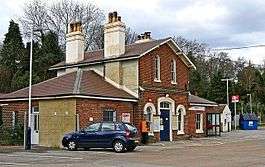
Witley railway station
| Witley | |
|---|---|
 | |
| Location | |
| Place | Wormley |
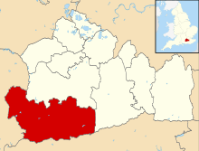
| Local authority | Waverley |
| Grid reference | SU948379 |
| Operations | |
| Station code | WTY |
| Managed by | South Western Railway |
| Number of platforms | 2 |
| DfT category | E |
|
Live arrivals/departures, station information and onward connections from National Rail Enquiries | |
| Annual rail passenger usage* | |
| 2012/13 |
|
| 2013/14 |
|
| 2014/15 |
|
| 2015/16 |
|
| 2016/17 |
|
| History | |
| 1 January 1859 | Opened (Witley and Chiddingfold) |
| 6 October 1947 | Renamed (Witley) |
| National Rail – UK railway stations | |
| * Annual estimated passenger usage based on sales of tickets in stated financial year(s) which end or originate at Witley from Office of Rail and Road statistics. Methodology may vary year on year. | |
|
| |
Witley railway station is a station on the Portsmouth Direct Line in Surrey, England. It is 38 miles 36 chains (61.9 km) down the line from London Waterloo via Woking.[1]
Service overview
Witley is, equally with Milford to the north-east, a minor stop on the Portsmouth Direct Line 38½ miles (62 km) south-west of London Waterloo. When opened, it was named Witley and Chiddingfold.
Its nearest communities without major stations are Wormley, the southern part of Witley (the north of which is served by Milford railway station), Hambledon and Chiddingfold,
Services
An hourly service to Haslemere operates southbound and London Waterloo northbound, which increases to a half-hourly service calling at among others successive stations Haslemere, Fratton, Havant, Portsmouth & Southsea and Portsmouth Harbour during peak times. Services are nearly all operated by Class 450 "Desiros", however one weekday service in each direction is provided by a Class 444 "Desiro"
| Preceding station | Following station | |||
|---|---|---|---|---|
| Milford | South Western Railway Portsmouth Direct Line |
Haslemere | ||
References
External links
- Train times and station information for Witley railway station from National Rail