Thursley
| Thursley | |
|---|---|
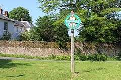 Small village green and sign | |
 Thursley Thursley shown within Surrey | |
| Area | 19.85 km2 (7.66 sq mi) |
| Population | 651 (Civil Parish 2011)[1] |
| • Density | 33/km2 (85/sq mi) |
| OS grid reference | SU9040 |
| Civil parish |
|
| District | |
| Shire county | |
| Region | |
| Country | England |
| Sovereign state | United Kingdom |
| Post town | Godalming |
| Postcode district | GU8 |
| Dialling code | 01252 |
| Police | Surrey |
| Fire | Surrey |
| Ambulance | South East Coast |
| EU Parliament | South East England |
| UK Parliament | |
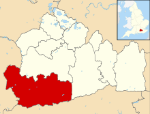
Thursley is a village and civil parish in southwest Surrey, west of the A3 between Milford and Hindhead. An associated hamlet is Bowlhead Green. To the east is Brook. In the south of the parish rises the Greensand Ridge, in this section reaching its escarpment near Punch Bowl Farm and the Devil's Punch Bowl, Hindhead.
History
The village's name came from Old English Þunres lēah meaning lea of the god Thunor or Thor (in his northern guise), just as Thundersley, Essex; it was probably a site where he was worshipped. There is a rocky outcrop near the village referred to in Victorian guides to the area as Thor's Stone. This stone, according to the Surrey Archaeological Collection (volume 88), is first mentioned in Saxon times as being "near Peper Harow", an adjacent parish with known pagan connections. The precise stone or rocks this refers to is now uncertain with some sources indicating it could be the rocky outcrop and others suggesting it may be an ancient Celtic boundary stone found on the margin of Pudmore pond on Ockley Common.
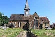
The small parish church, dedicated to St Michael and All Angels, has a finely carved Anglo-Saxon font and two surviving Anglo-Saxon windows in the chancel, which exceptionally retain their original wooden frames. Its small wooden shingled belfry is strangely underpinned by an unnecessarily large and sturdy late medieval framework of heavy timber. The remains of a gnarled ancient tree are nearby. In the churchyard there is the gravestone of the Unknown Sailor.
There have been several military camps in the parish.[2] Between 1922 and 1957 there existed Thursley Camp (from 1941 renamed Tweedsmuir Camp) to the north west of the village which housed British, Canadian and American forces at various times. On 7 November 1942 it was bombed by the German air force. After world war two it was used to house displaced Poles. To the west was Houndown Camp which was used by the British Royal Marines.
Geography


The north of the parish is mostly Thursley Nature Reserve, a sandy and seasonally marshy Site of Special Scientific Interest, the lowest part of a larger area of uncultivated open land made up of the remainder of Thursley Common and of Witley Common. Across the A3 is the main hillside neighbourhood of Thursley, Bowlhead Green, which has an underpass path crossing directly between the two on the Greensand Way. The two are also connected via one of the largest junctions of the A3 road in the north of the parish, in terms of its multiple slip roads, which facilitate access for the Ministry of Transport to the restricted land to the far north, Hankley Common.
Wildlife
Thursley Common is a national nature reserve and SSSI. It is one of the last surviving areas of lowland peat bog in southern Britain, and at 350 hectares, one of the largest remaining fragments of heathland. It provides a particularly rich habitat for dragonflies and damselflies, along with many other species including the endangered woodlark and Dartford warbler. In July 2006 during a heat wave that affected southern England, 60% of the common was burnt.[3]
Notable residents
- Mary Bennett, Principal of St Hilda's College, Oxford
- Monica Edwards wrote the Punch Bowl Farm series at the eponymous farm from 1947 to 1970. Thereafter she and her husband lived in a retirement bungalow built in one of its fields.
- Herbert Albert Laurens Fisher was an English historian, educator, and Liberal politician. He served as President of the Board of Education in David Lloyd George's 1916 to 1922 coalition government.[4][5] He was also Warden of New College, Oxford from 1925 to 1940.
- Lettice Fisher founded the National Council for the Unmarried Mother and her Child, now known as Gingerbread. Both Lettice Fisher and Mary Bennett died at Rock Cottage in Thursley.[6]
- Sir Edwin Lutyens, architect, grew up in the village where some of his earliest work is to be found. While making use of modern concrete for large spaces, exemplified by his bridges, his churches and homes incorporated methods of traditional timber framing, long tile or slate roofs, distinctive eaves or in appropriately grand settings Bargate or Bath stone. The inspiration was walking in the surrounding area that he developed his love and appreciation of vernacular (authentic Arts and Crafts) buildings, in particular their woodwork, fenestration, tiling and materials.
- Sir Roger Stevens, diplomat and Vice-Chancellor of the University of Leeds
- Margaret Louisa Woods, writer
Demography and housing
| Output area | Detached | Semi-detached | Terraced | Flats and apartments | Caravans/temporary/mobile homes | shared between households[1] |
|---|---|---|---|---|---|---|
| (Civil Parish) | 165 | 49 | 13 | 15 | 35 | 0 |
The average level of accommodation in the region composed of detached houses was 28%, the average that was apartments was 22.6%.
| Output area | Population | Households | % Owned outright | % Owned with a loan | hectares[1] |
|---|---|---|---|---|---|
| (Civil Parish) | 651 | 277 | 53.4% | 25.6% | 1,985 |
The proportion of households in the civil parish who owned their home outright compares to the regional average of 35.1%. The proportion who owned their home with a loan compares to the regional average of 32.5%. The remaining % is made up of rented dwellings (plus a negligible % of households living rent-free).
References
- 1 2 3 Key Statistics; Quick Statistics: Population Density United Kingdom Census 2011 Office for National Statistics Retrieved 21 November 2013
- ↑ Tweedsmuir Military Camp
- ↑ English Nature – Thursley Common Fire
- ↑ Murray, G (December 1941). "Herbert Albert Laurens Fisher. 1865–1940". Obituary Notices of Fellows of the Royal Society. 10. 3: 518–529. doi:10.1098/rsbm.1941.0019.
- ↑ "H.A.L. Fisher, Thursley, to the Prime Minister. Private". The National Archives. 27 March 1921. Retrieved 21 February 2016.
- ↑ Goldman, Lawrence (2013-03-07). Oxford Dictionary of National Biography 2005-2008. OUP Oxford. ISBN 9780199671540.
External links
| Wikimedia Commons has media related to Thursley. |
- Thursley Parish 2008: Village Design Statement
- Wey River: Thursley National Nature Reserve
- St. Michael & All Angels, Thursley: Parish Profile 22 March 2010
- Stained Glass Windows at St. Michael & All Angels, Thursley, Surrey