Deyrintar
| Deyrintar دير انطار | |
|---|---|
| City | |
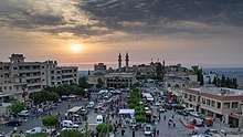
 Main Square | |
 Deyrintar Location within Lebanon | |
| Coordinates: 33°13′07″N 35°22′33″E / 33.21861°N 35.37583°ECoordinates: 33°13′07″N 35°22′33″E / 33.21861°N 35.37583°E | |
| Grid position | 185/291 PAL |
| Country |
|
| Governorate | Nabatieh |
| District | Bint Jbeil |
| Highest elevation | 670 m (2,200 ft) |
| Lowest elevation | 540 m (1,770 ft) |
| Time zone | UTC+2 (EET) |
| • Summer (DST) | UTC+3 (EEST) |
| Dialing code | +961 |
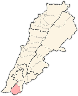
Deyrintar (Dayr Antar, Deir Intar, Arabic: دير انطار) is a small village in Southern Lebanon in the Bint Jbeil District in Nabatieh Governorate.
Geography
It is about 110 kilometres (68 mi) south of Beirut and 25 kilometres (16 mi) east of Tyre, in the heart of what is known as "Jabal Amel".
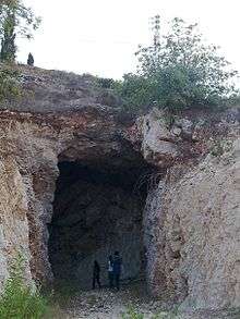
Its main features include a cave, a main square, and 3 mosques.
Location
The village is surrounded several villages including: Tebnine, As-Sultaniyah, Bir El Sanasel, , Majadel, Mahrouna, Mazraat Mechref, Hariss, Kfardounine, and other southern villages.
Origin of name
E. H. Palmer wrote that the name means " the convent of arches".[1]
History
In 1875 Victor Guérin visited and found here 160 Metualis.[2] He further noted: "Most of the houses show a mixture of old hewn stones and modern materials without character. Several tombs, cisterns, a great press, with two compartments, and a rock-cut tank point to a period of more or less antiquity.'[3]
In 1881, the Palestine Exploration Fund's Survey of Western Palestine (SWP) described it as: A village, built of stone, containing about 150 Metawileh, situated on a hill, surrounded by olives, fig-trees, and arable land, with waters supplied from birket and cisterns.[4]
Families
- House of Yassine
- House of Hojeij or Hajaig
- House of Sheayto
- House of Al-atrash
- House of Nasserdinne
- House of Mehssin al-madi
- House of Abou raya
- House of Moujir
- House of Al-dayekh
- House of Kassir
- House of Al-attar
- House of Sheaytille
Municipal
Mayor: Mr. Kassem Hajaig or hojeij
Religious Monuments
There are 3 Mosques:
- Mosque Imam Mahdi (Almallule)
- Mosque Imam Hussein (Al-Barakah)
- Mosque Imam Ali (Al-shajara)
- Mosque ALl-Hamra
The Imam or khatib of Deyrintar are:
- Sheikh Houssain Alatrash
- Sheikh Haitham Youssef Hjej
Civilian Facilities
- The municipal building
- Shiite shrine
- The public square
Monuments
The most prominent landmarks:
- Beaufort bees
- Ein zarka
- The cave
References
Bibliography
- Conder, C.R.; Kitchener, H.H. (1881). The Survey of Western Palestine: Memoirs of the Topography, Orography, Hydrography, and Archaeology. 1. London: Committee of the Palestine Exploration Fund.
- Guérin, V. (1880). Description Géographique Historique et Archéologique de la Palestine (in French). 3: Galilee, pt. 2. Paris: L'Imprimerie Nationale.
- Palmer, E.H. (1881). The Survey of Western Palestine: Arabic and English Name Lists Collected During the Survey by Lieutenants Conder and Kitchener, R. E. Transliterated and Explained by E.H. Palmer. Committee of the Palestine Exploration Fund.
External links
- Survey of Western Palestine, Map 2: IAA, Wikimedia commons
- Deir Ntar, Localiban
Capital: Bint Jbeil | ||
| Towns and villages |
|  |
| Notable landmarks | ||
| Other sites | ||