Davis Mountains
| Davis Mountains Limpia Mountains | |
|---|---|
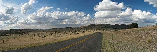
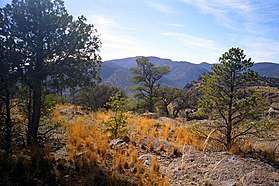 View from Remington Ridge | |
| Highest point | |
| Peak | Baldy Peak atop Mount Livermore |
| Elevation | 8,383 ft (2,555 m) |
| Coordinates | 30°38′N 104°10′W / 30.633°N 104.167°WCoordinates: 30°38′N 104°10′W / 30.633°N 104.167°W |
| Geography | |
 Davis Mountains Limpia Mountains | |
| Country | United States |
| State | Texas |
| Geology | |
| Age of rock | Paleogene |
| Type of rock | Igneous |
The Davis Mountains, originally known as Limpia Mountains, are a range of mountains in West Texas, located near Fort Davis, after which they are named for United States Secretary of War Jefferson Davis. They are a popular site for camping and hiking and the region includes Fort Davis National Historic Site and Davis Mountains State Park. The historical and architectural value of the fort, along with the rugged natural environment of the park are a significant destination for tourism in Texas.
Description
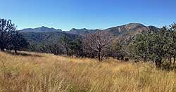
Rather than being a single coherent range, the Davis Mountains are an irregular jumble of isolated peaks and ridges separated by flatter areas. The mountains occupy a rough square about 50 kilometres (31 mi) on each side. The mountains are of volcanic origin composed of strata associated with eruptions of the Trans-Pecos Texas volcanic field 35 million years ago.[1] The highest peak in the Davis Mountains is Mount Livermore at 2,555 metres (8,383 ft) the fifth highest peak in Texas.
Vegetation
The Davis Mountains are a sky island, an isolated mountain range surrounded by desert. The town of Fort Davis at the foot of the Davis Mountains has an elevation of 1,500 metres (4,900 ft). From that elevation the sky island rises to 2,555 metres (8,383 ft). As the elevation increases, average temperatures decline and precipitation increases permitting an "island" of forest and other mesic habitat at higher elevations.
The most common vegetation of the Davis Mountains is montane grassland, often mixed with scattered bushes and trees. As is common in most northern hemisphere semi-arid climates the vegetation on the southern slopes of the mountains is noticeably sparser than on the northern slopes. This is due to the greater exposure to the sun on southern slopes and, thus, warmer temperatures and drier soils.[2]
Mixed in with the grassland, and usually at higher elevations, are four woodland and forest zones. First, at elevations below 1,900 metres (6,200 ft) and at higher, drier elevations the dominate tree species is the alligator juniper mixed with oak species and pinyon pine. Secondly, woodlands with pinyon pine as the most common species are found on steep slopes at elevations of 1,750 metres (5,740 ft) to 2,400 metres (7,900 ft). Third, woodlands in which the gray oak is the most common tree and mixed with other oak species are also found on steep slopes at elevations of 1,900 metres (6,200 ft) to 2,400 metres (7,900 ft). The gray oak woodlands are found in slightly moister soils than the pinyon woodlands.[3]
The richest and most diverse of the woodlands and forests in the Davis Mountains are the mesic forests found from 1,770 metres (5,810 ft) to 2,330 metres (7,640 ft). These forests are found in stream valleys and other well-watered areas. Indicator species are ponderosa pine and southwestern white pine, plus two small groves of quaking aspen at elevations of 2,300 metres (7,500 ft) at the base of the cliffs surrounding the summit of Mount Livermore. Aspens are more characteristic of the higher elevations in the Rocky Mountains. The mesic woodlands are remnants of past glacial ages in which the climate of west Texas was more humid and cooler than at present.[4]
Fauna
277 species of birds have been seen at Davis Mountains State Park.[5] Many species found here are characteristic of more northerly mountain climes or alternatively of nearby Mexico, including 10 species of hummingbirds. Large mammals found here include whitetail deer, mule deer, elk, black bear, cougar, pronghorn, peccary, and introduced species such as aoudad and feral hogs. Several private ranches in the Davis Mountains offer hunting opportunities.[6]
Climate
Nearly all of the Davis Mountains fall into the climate classification of BS (semi-arid steppe) in the Köppen climate classification system. However, the highest elevations may transition into a cooler, wetter Cfb climate (sub tropical humid with warm summers).
| Climate data for Mount Locke weather station, Texas. (Elevation 2,070 metres (6,790 ft)) | |||||||||||||
|---|---|---|---|---|---|---|---|---|---|---|---|---|---|
| Month | Jan | Feb | Mar | Apr | May | Jun | Jul | Aug | Sep | Oct | Nov | Dec | Year |
| Record high °F (°C) | 80 (27) |
79 (26) |
88 (31) |
94 (34) |
96 (36) |
104 (40) |
100 (38) |
104 (40) |
96 (36) |
94 (34) |
82 (28) |
80 (27) |
104 (40) |
| Average high °F (°C) | 53.5 (11.9) |
56.9 (13.8) |
63.7 (17.6) |
71.4 (21.9) |
78.6 (25.9) |
84.5 (29.2) |
82.7 (28.2) |
81.3 (27.4) |
76.6 (24.8) |
70.5 (21.4) |
61.2 (16.2) |
54.4 (12.4) |
69.6 (20.9) |
| Average low °F (°C) | 32.0 (0) |
33.9 (1.1) |
38.2 (3.4) |
45.2 (7.3) |
52.4 (11.3) |
58.2 (14.6) |
58.9 (14.9) |
58.4 (14.7) |
54.4 (12.4) |
48.0 (8.9) |
38.7 (3.7) |
33.6 (0.9) |
46.0 (7.8) |
| Record low °F (°C) | −10 (−23) |
−6 (−21) |
4 (−16) |
11 (−12) |
26 (−3) |
36 (2) |
40 (4) |
40 (4) |
29 (−2) |
13 (−11) |
8 (−13) |
−2 (−19) |
−10 (−23) |
| Average precipitation inches (mm) | 0.68 (17.3) |
0.49 (12.4) |
0.40 (10.2) |
0.50 (12.7) |
1.63 (41.4) |
2.49 (63.2) |
3.83 (97.3) |
3.69 (93.7) |
2.95 (74.9) |
1.61 (40.9) |
0.61 (15.5) |
0.60 (15.2) |
19.46 (494.3) |
| Source: The Western Regional Climate Center[7] | |||||||||||||

Conservation
Most of the Davis Mountains are in private ownerships. However, since 1996, The Nature Conservancy has acquired 33,000 acres (130 km²) in the Davis Mountains range, along with conservation easements on 70,000 adjoining acres (280 km²) of private ranchland. The Davis Mountain Preserve is open to the public at specified times.
Facilities
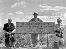
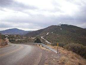
McDonald Observatory is accessed by Spur 78 from State Highway 118. Spur 78 is the highest state maintained road in Texas at 6,791 feet near the summit of Mt. Locke where the older telescopes of the observatory are located. Spur 77 branches off from Spur 78 providing access to the newer research equipment atop Mt. Fowlkes.
Texas Separatist Standoff
The Texas separatist organization known as the Republic of Texas has its origins in the Davis Mountains. On April 27, 1996, the leader of the group, Rick McLaren, staged an attack on his neighbor's house and demanded that he cede his property to the Republic of Texas. This led to 300 state troopers surrounding his house with him, his five followers, his wife, and the victims of the attack inside for close to a week. Ultimately, one follower was shot in the standoff and McLaren was arrested and imprisoned for the equivalent of a life sentence. [8]
References
- ↑ "40Ar/39Ar chronology and volcanology of silicic volcanism in the Davis Mountains, Trans-Pecos Texas", doi:10.1130/0016-7606(1994)106<1359:AACAVO>2.3.CO;2 Geological Society of America Bulletin November 1994 v. 106 no. 11 p. 1359-1376, accessed September 13, 2010
- ↑ Cottle, H. J. (Apr 1932), "Vegetation on North and South Slopes of Mountains in Southwestern Texas," Ecology, Vol 13, No 2, p. 121
- ↑ Poulos, Helen M.; et al. (2007). "A hierarchical approach for scaling forest inventory and fuels data from local to landscape scales in the Davis Mountains, Texas, USA". Forest Ecology and Management. 244: 1–15.
- ↑ Poulos et al; Palmer, Ernest J. (January 1929). "The Ligneous Flora of the David Mountains, Texas". Journal of the Arnold Arboretum. 10 (1): 13, 32, 37. Accessed from JSTOR.
- ↑ "Birdwatching," https://www.birdwatchingdaily.com/hotspots/100-davis-mountains-state-park-fort-davis-texas/, accessed 17 May 2017
- ↑ "Fort Davis Texas", https://fortdavis.com/category/activities/hunting/; The Nature Conservancy, https://www.nature.org/ourinitiatives/regions/northamerica/unitedstates/texas/placesweprotect/davis-mountains-preserve.xml, accessed 17 May 2017
- ↑ "Seasonal Temperature and Precipitation Information". Western Regional Climate Center. Retrieved April 1, 2013.
- ↑ Branson, Hailey. "Today in Texas History: Long live Republic of Texas! Separatist group standoff in mountains begins". Houston Chronicle.
External links
| Wikimedia Commons has media related to Davis Mountains. |
- Davis Mountains from the Handbook of Texas Online
- Davis Mountains and Indian Lodge - December 5, 2007 - Houston Chronicle
- Davis Mountains photographs, hosted by the Portal to Texas History
- Davis Mountains State Park - Texas Parks and Wildlife
- Davis Mountains Preserve - Nature Conservancy
- U.S. Geological Survey Geographic Names Information System: Davis Mountains