Texas State Highway Spur 78
| ||||
|---|---|---|---|---|
| Route information | ||||
| Maintained by TxDOT | ||||
| Length | 1.547 mi[1] (2.490 km) | |||
| Existed | September 26, 1939–present | |||
| Major junctions | ||||
| South end | Mt. Locke summit, McDonald Observatory | |||
|
| ||||
| North end |
| |||
| Location | ||||
| Counties | Jeff Davis | |||
| Highway system | ||||
| ||||

Texas State Highway Spur 78 or Spur 78 is a spur road maintained by the Texas Department of Transportation (TxDOT) connecting the University of Texas at Austin's McDonald Observatory complex atop Mt. Locke to State Highway 118 15.2 miles (24.5 km) from Fort Davis.[2] The road is 1.5 miles (2.4 km) long and is located within Jeff Davis County.
History
Spur 78 was established on April 24, 1933 as SH 166 Spur[3] to aid in the construction of the observatory which was dedicated in 1939.[4] It was renumbered Spur 78 on September 26, 1939. Before 1941, the road connected the observatory to SH 166 until the section of that route between Fort Davis and the current intersection of SH 118 and SH 166 was re-designated as part of SH 118.[5] On October 5, 1990, the only other intersecting highway, Spur 77, was created.[6]
Route description
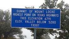
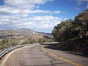
At its terminus at the summit of Mt. Locke, Spur 78 has the distinction of having the highest elevation at any point on the state highway system with an elevation of 6,791 feet (2,070 m).[7] The route begins in front of the Otto Struve Telescope and Harlan J. Smith Telescope where there is a scenic overlook of the valley below and the surrounding Davis Mountains.
Initially the route has steep grades as it descends from the summit of the mountain. After 0.5 miles (0.8 km) the route intersects Spur 77 toward nearby Mt. Fowlkes where the observatory has another cluster of facilities. Spur 78 also intersects a few observatory service roads to maintenance facilities and residential areas. The observatory passes by the observatory's Frank N. Bash Visitors Center before terminating at SH 118.
Major intersections
The entire route is in McDonald Observatory, Jeff Davis County.
| mi[8] | km | Destinations | Notes | ||
|---|---|---|---|---|---|
| 0 | 0.0 | Mt. Locke summit | Southern terminus | ||
| 0.5 | 0.80 | Mt. Fowlkes spur | |||
| 1.5 | 2.4 | Northern terminus | |||
| 1.000 mi = 1.609 km; 1.000 km = 0.621 mi | |||||
See also


References
- ↑ Transportation Planning and Programming Division (n.d.). "State Highway Spur No. 78". Highway Designation Files. Texas Department of Transportation. Retrieved 2009-12-12.
- ↑ Google (2009-12-12). "SH 118 between Fort Davis and Spur 78" (Map). Google Maps. Google. Retrieved 2009-12-12.
- ↑ Staff (April 24, 1933). "Minute Order 7503, Minutes of the One Hundred Sixty-fourth Meeting of the State Highway Commission" (PDF). Texas State Highway Commission. p. 4. Retrieved July 29, 2017.
- ↑ Evans, David S. (2009-11-11). "University of Texas at Austin McDonald Observatory". The Handbook of Texas Online. Texas State Historical Association. Retrieved 2009-12-12.
- ↑ Transportation Planning and Programming Division (n.d.). "State Highway No. 166". Highway Designation Files. Texas Department of Transportation.
- ↑ Transportation Planning and Programming Division (n.d.). "State Highway Spur No. 77". Highway Designation Files. Texas Department of Transportation.
- ↑ "Mount Locke Summit, near Fort Davis, Texas 6791 Ft - Elevation Signs on Waymarking.com". Groundspeak, Inc. Retrieved 2009-12-12.
- ↑ Google (2009-12-12). "Route of Spur 78" (Map). Google Maps. Google. Retrieved 2009-12-12.
External links
Route map:

- McDonald Observatory website