Dannenfels
| Dannenfels | ||
|---|---|---|
| ||
 Dannenfels Location of Dannenfels within Donnersbergkreis district 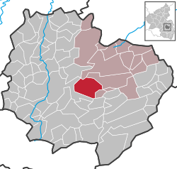 | ||
| Coordinates: 49°37′42.10″N 7°56′34.60″E / 49.6283611°N 7.9429444°ECoordinates: 49°37′42.10″N 7°56′34.60″E / 49.6283611°N 7.9429444°E | ||
| Country | Germany | |
| State | Rhineland-Palatinate | |
| District | Donnersbergkreis | |
| Municipal assoc. | Kirchheimbolanden | |
| Government | ||
| • Mayor | Ludwig Denzer | |
| Area | ||
| • Total | 15.79 km2 (6.10 sq mi) | |
| Elevation | 400 m (1,300 ft) | |
| Population (2017-12-31)[1] | ||
| • Total | 850 | |
| • Density | 54/km2 (140/sq mi) | |
| Time zone | CET/CEST (UTC+1/+2) | |
| Postal codes | 67814 | |
| Dialling codes | 06357 | |
| Vehicle registration | KIB | |
| Website | www.dannenfels.de | |

Dannenfels is a municipality in the Donnersbergkreis district, in Rhineland-Palatinate, Germany.
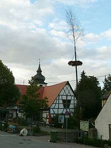
Timberframe, church and maypole
References
- ↑ Statistisches Landesamt Rheinland-Pfalz "Bevölkerungsstand 2017 - Gemeindeebene" Check
|url=value (help). Statistisches Landesamt Rheinland-Pfalz (in German). 2018.
| Wikimedia Commons has media related to Dannenfels. |
| Authority control |
|---|
This article is issued from
Wikipedia.
The text is licensed under Creative Commons - Attribution - Sharealike.
Additional terms may apply for the media files.