Albisheim
| Albisheim | ||
|---|---|---|
| ||
 Albisheim Location of Albisheim within Donnersbergkreis district _in_KIB.svg.png) | ||
| Coordinates: 49°39′00″N 8°6′00″E / 49.65000°N 8.10000°ECoordinates: 49°39′00″N 8°6′00″E / 49.65000°N 8.10000°E | ||
| Country | Germany | |
| State | Rhineland-Palatinate | |
| District | Donnersbergkreis | |
| Municipal assoc. | Göllheim | |
| Government | ||
| • Mayor | Friedrich Strack | |
| Area | ||
| • Total | 10.74 km2 (4.15 sq mi) | |
| Elevation | 150-170 m (−410 ft) | |
| Population (2017-12-31)[1] | ||
| • Total | 1,740 | |
| • Density | 160/km2 (420/sq mi) | |
| Time zone | CET/CEST (UTC+1/+2) | |
| Postal codes | 67308 | |
| Dialling codes | 06355 | |
| Vehicle registration | KIB | |
| Website | www.albisheim.info | |

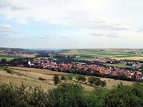
View from wine hill over the village
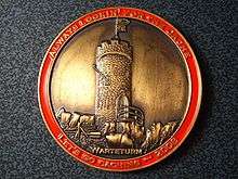
The Warteturm on a coin of the game Geocaching
Albisheim is a municipality in the Donnersbergkreis, Rhineland-Palatinate, Germany. It is in the middle of the Zellertal.
History
In the year 835 the village is first mentioned in a document. It has been a market town for many years. Also there was a palace, but it hasn't yet been found.
Traffic
Near Albisheim there is the trunk B 47, and the village has also a railway station.
Sights
- the Protestant church from 1792,
- the historic town hall, a classicist building from 1832 and
- the 26-feet-high (8 metres) Warteturm at the wine hill. It was first mentioned 1551.
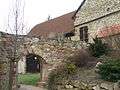 Upper melting mill
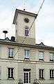 Town hall
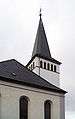 Peter's church
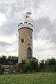 The Warteturm upon the wine hill
References
- ↑ Statistisches Landesamt Rheinland-Pfalz "Bevölkerungsstand 2017 - Gemeindeebene" Check
|url=value (help). Statistisches Landesamt Rheinland-Pfalz (in German). 2018.
This article is issued from
Wikipedia.
The text is licensed under Creative Commons - Attribution - Sharealike.
Additional terms may apply for the media files.