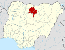
Dala, Kano
| Dala | |
|---|---|
| LGA and town | |
 Dala Location in Nigeria | |
| Coordinates: 12°01′N 8°29′E / 12.017°N 8.483°ECoordinates: 12°01′N 8°29′E / 12.017°N 8.483°E | |
| Country |
|
| State | Kano State |
| Government | |
| • Local Government Chairman and the Head of the Local Government Council | Alh. Ibrahim Suleiman Dan’isle |
| Area | |
| • Total | 19 km2 (7 sq mi) |
| Population (2006 census) | |
| • Total | 418,777 |
| Time zone | UTC+1 (WAT) |
| 3-digit postal code prefix | 700 |
| ISO 3166 code | NG.KN.DL |
Dala is a densely populated Local Government Area in Kano State, Nigeria within Kano city created in May, 1989 from the old Kano Municipal Local Government. It is located in the North-west part of the Kano metropolis. Its headquarters are in the Gwammaja locality.
History
It contains Dalla Hill from which it got its name[1] and was once the capital of the Sultanate of Kano.
Geography
It has an area of 19 km² and a population of 418,777 at the 2006 census. It is thus the largest Local Government Area in Nigeria.[1]
The postal code of the area is 700.[2]
Economy
Among popular economic and commercial activities in Dalla are dyeing, black smith, pot making, farming, fishing, shoe making and other commercial undertakings.
Politics
The Local Government is dubbed in Hausa as 'Cibiyar Dimokaradiyar Nigeria' meaning 'the Democratic Centre of Nigeria'.
Education
One of Nigeria's unity schools, the Government Girls College is in Dala.
Personalities
It is the birthplace of the politician Mallam Aminu Kano whose personal residence was converted to the Centre for Democratic Research and Training by the Federal Government in order to immortalize his name and preserve his teachings and ideas for future generations.
Another prominent indigene is business mogul and Nigerian billionaire, Alhaji Aminu Dantata.
References
- 1 2 Nigeria, US Embassy. "Amb Campbell's Speech" (PDF). SPEECH OF THE LOCAL GOVERNMENT CHAIRMAN CARETAKER COMMITTEE (ALHAJI MAHMUD SANI MADAKIN) DURING THE VISIT OF THE AMERICA AMBASSADOR TO NIGERIA AT G.G.C. DALA ON SATURDAY 2ND JUNE, 2007. US Embassy Nigeria. Retrieved 10 May 2016.
- ↑ "Post Offices- with map of LGA". NIPOST. Archived from the original on October 7, 2009. Retrieved 2009-10-20.
