Cradock, South Australia
| Cradock South Australia | |||||||||||||||
|---|---|---|---|---|---|---|---|---|---|---|---|---|---|---|---|
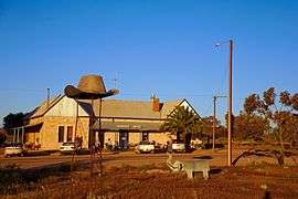 The Cradock Hotel. | |||||||||||||||
 Cradock | |||||||||||||||
| Coordinates | 32°04′21″S 138°29′34″E / 32.072377°S 138.492776°ECoordinates: 32°04′21″S 138°29′34″E / 32.072377°S 138.492776°E[1] | ||||||||||||||
| Established |
6 March 1879 (town) 25 November 1999 (locality)[2][3] | ||||||||||||||
| Postcode(s) | 5432 | ||||||||||||||
| Elevation | 410 m (1,345 ft) | ||||||||||||||
| Location | 320 km (199 mi) N of Adelaide | ||||||||||||||
| LGA(s) | |||||||||||||||
| Region | Far North[1] | ||||||||||||||
| County | Granville[1] | ||||||||||||||
| State electorate(s) | Stuart | ||||||||||||||
| Federal Division(s) | Grey | ||||||||||||||
| |||||||||||||||
Cradock is a settlement 320 kilometres north of Adelaide on the RM Williams Way in South Australia. The nearest town with a greater population is Hawker which is approximately 20 km away with a population of around 360. Cradock is in the Flinders Ranges Council area, the state Electoral district of Stuart and the federal Division of Grey. The southern part of the locality is in the electoral district of Stuart and District Council of Orroroo Carrieton.
The town was surveyed during November 1878 and proclaimed on 6 March 1879. The locality's boundaries were gazetted on 25 November 1999 and include the Government Town of Cradock and the sites of the ceased Government Towns of Charlcome and Herbert.[1]
After the South Australian government permitted settlers to go into the semi-arid lands north of Goyder's Line Cradock was established in 1879 on a 'grassy flat' of 'strong red loam', by the Wirreanda Creek. Cradock takes its name from the then Governor of South Africa, Sir John Cradock.[4]
Soon after settlement, a school, police station, two hotels, two blacksmith shops and a saddler were operating in Cradock. The "wheat rush" was followed by the failure of four years of crops which led to an increasing despair and a loss of many of the town’s population.[4]
Historic buildings
Cradock had three churches. The stone Catholic church opened in 1883. The Wesleyan Methodist church built in 1884 was weatherboard and iron, replaced by a stone church (construction started in 1924[5]) which was used into the 1980s, but is now a private residence.[6] The stone Anglican church built in 1894 was used until 1958 and is also now a private residence.[7]
The historic former St Gabriel's Catholic Church designed by Thomas Burgoyne in Main Street is listed on the South Australian Heritage Register.[8]
The town still has one hotel, the Cradock Hotel[9], known in earlier days as the Heartbreak Hotel.
References
- 1 2 3 4 "Search result for 'Cradock, LOCB' with the following datasets selected - 'Suburbs and Localities', 'Government Towns', 'Counties', 'Local Government Areas', 'SA Government Regions' and 'Gazetteer'". Location SA Map Viewer. South Australian Government. Retrieved 27 January 2018.
- ↑ "untitled (proclamation o fthe Town of Cradock)" (PDF), The South Australian Government Gazette (10): 625, 6 March 1879, retrieved 27 January 2018
- ↑ "GEOGRAPHICAL NAMES ACT 1991 Notice to Assign Boundaries and Names to Places" (PDF), The South Australian Government Gazette: 2442, 25 November 1999, retrieved 27 January 2018
- 1 2 Reader's Digest Illustrated Guide to Australian Places. Sydney, NSW: Reader's Digest. 1993. p. 534. ISBN 0-86438-399-1.
- ↑ "Advertising". Quorn Mercury. SA: National Library of Australia. 29 August 1924. p. 2. Retrieved 13 February 2016.
- ↑ "15 MAIN ROAD, Cradock SA 5432". Domain. Fairfax Media. Retrieved 12 February 2016.
- ↑ "Cradock". Flinders Ranges. Froling Enterprises & Lyn Leader-Elliott. 7 September 2012. Retrieved 12 February 2016.
- ↑ "Former St Gabriel's Catholic Church". South Australian Heritage Register. Department of Environment, Water and Natural Resources. Archived from the original on 15 February 2016. Retrieved 12 February 2016.
- ↑ "Cradock Hotel". Retrieved 12 February 2016.
