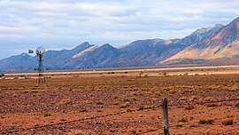
Flinders Ranges, South Australia
| Flinders Ranges South Australia | |||||||||||||||
|---|---|---|---|---|---|---|---|---|---|---|---|---|---|---|---|
 Ikara-Flinders Ranges National Park | |||||||||||||||
 Flinders Ranges | |||||||||||||||
| Coordinates | 31°29′24″S 138°29′13″E / 31.49°S 138.487°ECoordinates: 31°29′24″S 138°29′13″E / 31.49°S 138.487°E | ||||||||||||||
| Population | 104 (shared with other localities in the “State Suburb of Flinders Ranges”) (2016 census)[1] [lower-alpha 1] | ||||||||||||||
| Established | 2013[2] | ||||||||||||||
| Postcode(s) | 5434[2] | ||||||||||||||
| Time zone | ACST (UTC+9:30) | ||||||||||||||
| • Summer (DST) | ACST (UTC+10:30) | ||||||||||||||
| Location |
| ||||||||||||||
| LGA(s) |
Pastoral Unincorporated Area[2] Flinders Ranges Council[2] | ||||||||||||||
| Region | Far North[3] | ||||||||||||||
| County |
Blachford Hanson Taunton[2] | ||||||||||||||
| State electorate(s) |
Giles[4] Stuart[5] | ||||||||||||||
| Federal Division(s) | Grey [6] | ||||||||||||||
| |||||||||||||||
| |||||||||||||||
| Footnotes |
Location[2] Coordinates[2] Climate[7] | ||||||||||||||
Flinders Ranges is a locality in the Australian state of South Australia located in the mountain range of the same name, about 380 kilometres (240 miles) north of the state capital of Adelaide, about 86 kilometres (53 miles) north-east of the municipal seat of Quorn and about 131 kilometres (81 miles) north-east of the centre of Port Augusta in the state’s Far North region.[2][8]
Its boundaries were created in April 2013, with the name selected in respect to the ‘long established local name’. Its southern boundary was altered in November 2013 with the addition of land from Hawker and the transfer of land to Shaggy Ridge. The former government towns of Edeowie and Mernmerna are also within its boundaries.[2] These were both surveyed in 1863; Edeowie Post Office was open from c. 1870 to 1876 and from 1879 to 1881, while Mernmerna Post Office was open from 1874 to 1881 and again for a period in 1905.[9][10][11][12][13][14]
Flinders Ranges consists of the part of the mountain range between the ‘town centre’ of Hawker in the south and the 'town centre' of Parachilna in the north, as well as some land to the west of the range. In the north east it contains all of the protected areas of the Ikara-Flinders Ranges National Park and Bunkers Conservation Reserve, whose eastern boundaries align with that of the locality. The Marree railway line and The Outback Highway both pass through the west side of the locality while the Flinders Ranges Way passes through the south-east side.[2][15]
As of 2012, its land use was either pastoral farming or conservation. The Marree railway line is the boundary between these uses, with pastoral farming to the west and land to the east zoned for conservation, including the Ikara-Flinders Ranges National Park and the Bunker Conservation Reserve.[16]
Flinders Ranges is located within the federal division of Grey, the state electoral districts of Giles and Stuart, the Flinders Ranges Council and the Pastoral Unincorporated Area of South Australia.[6][4][2][5]
Heritage listings
Flinders Ranges contains a number of places listed on the South Australian Heritage Register, including:
- Ajax Mine Fossil Reef [17]
- Aroona Valley: Hayward Homestead Ruins [18]
- Aroona Valley: Eddie Pumpa Outstation [19]
- Brachina Gorge: Impact Ejecta Horizon Late Precambrian Shales Geological Site [20]
- Brachina Road: Enorama Outstation and Mail Station Ruins [21]
- Wilpena Pound Geological Landform [22]
- Stromatolites in the Precambrian Trezona Formation, Ikara-Flinders Ranges National Park [23]
- Wilkawillina Archaeocyathae Geological Site [24]
- Oraparinna Diapir [25]
- Tufa Waterfall [26]
- Enorama Diapir [27]
- Appealinna Mine Ruins and Miner's Hut [28]
- Blacksmith's Shop, Oraparinna Station [29]
- Dingley Dell Homestead Ruins [30]
- Wills Homestead Complex Ruins [31]
- Hill's Cottage, Wilpena Pound [32]
- Wilpena Homestead Complex [33]
- Pichi Richi Railway[34][35][36][37]
Adjoining localities
Flinders Ranges is bounded by the following localities:[2]
- Northwest: Motpena,
- North: Motpena, Mount Falkland, Alpana, Gum Creek Station and Agorigina.
- Northeast: Wirrealpa
- East: Wirrealpa, Willow Springs, Upalinna, Prelinna, Mount Havelock and Willippa.
- Southeast: Black Hill Station
- South: Barndioota, Hawker, Shaggy Ridge and Black Hill Station
- Southwest: Wallerberdina
- West: Motpena, Wintabatinyana, Lake Torrens Station
See also
References
- Notes
- ↑ For the 2016 census, the ‘State Suburb of Flinders Ranges’ consisted of Flinders Ranges and other adjoining localities.
- Citations
- ↑ Australian Bureau of Statistics (27 June 2017). "Flinders Ranges". 2016 Census QuickStats. Retrieved 26 January 2018.

- 1 2 3 4 5 6 7 8 9 10 11 12 "Search result for "Flinders Ranges (Locality Bounded)" (Record no SA0067059) with the following layers being selected - "Suburbs and Localities", "Government Towns", "Counties", "Place names (gazetteer)", "Road Labels", "Development Plan Layers" and " Zone Categories"". Property Location Browser. Government of South Australia. Retrieved 18 July 2016.
- ↑ "Far North SA Government region" (PDF). The Government of South Australia. Retrieved 11 December 2016.
- 1 2 "District of Giles Background Profile". Electoral Commission SA. Retrieved 14 May 2016.
- 1 2 "District of Stuart Background Profile". Electoral Commission SA. Retrieved 20 August 2015.
- 1 2 "Federal electoral division of Grey" (PDF). Australian Electoral Commission. Retrieved 24 July 2015.
- ↑ "Monthly climate statistics: Summary statistics Hawker (nearest weather station)". Commonwealth of Australia , Bureau of Meteorology. Retrieved 18 July 2016.
- ↑ "Far North SA government region" (PDF). Government of South Australia. Retrieved 16 August 2015.
- ↑ "Search result for "Edeowie (Gtwn)" with the following layers being selected - "Suburbs and Localities", "Government Towns", "Place names (gazetteer)", "Road Labels", "Development Plan Layers" and " Zone Categories"". Property Location Browser. Government of South Australia. Retrieved 18 July 2016.
- ↑ "Search result for "Mernmerna (Gtwn)" with the following layers being selected - "Suburbs and Localities", "Government Towns", "Place names (gazetteer)", "Road Labels", "Development Plan Layers" and " Zone Categories"". Property Location Browser. Government of South Australia. Retrieved 18 July 2016.
- ↑ "Edeowie (1)". Post Office Reference. Premier Postal. Retrieved 19 July 2016.
- ↑ "Edeowie (2)". Post Office Reference. Premier Postal. Retrieved 19 July 2016.
- ↑ "Mernmerna (1)". Post Office Reference. Premier Postal. Retrieved 19 July 2016.
- ↑ "Mernmerna (2)". Post Office Reference. Premier Postal. Retrieved 19 July 2016.
- ↑ "Search result for "Flinders Ranges (Locality Bounded)" with the following datasets being selected - "Suburbs and Localities"". LocationSA Map Viewer. Government of South Australia. Retrieved 19 July 2016.
- ↑ "Development Plan, Land Not Within a Council Area (Flinders)– 29 November 2012" (PDF). Department of Planning, Transport and Infrastructure. 2012. pp. 40–41, 43–46, 47, 57–59 and 61–62. Archived from the original (PDF) on 2 October 2015. Retrieved 16 September 2015.
- ↑ "Ajax Mine Fossil Reef (designated place of palaeontological and geological significance)". South Australian Heritage Register. Department of Environment, Water and Natural Resources. Retrieved 19 July 2016.
- ↑ "Hayward Homestead (Ruin), Ikara-Flinders Ranges National Park". South Australian Heritage Register. Department of Environment, Water and Natural Resources. Retrieved 19 July 2016.
- ↑ "Eddie Pumpa Outstation including Outbuilding, Ikara-Flinders Ranges National Park". South Australian Heritage Register. Department of Environment, Water and Natural Resources. Retrieved 19 July 2016.
- ↑ "Impact Ejecta Horizon Late Precambrian Shales Geological Site, Ikara-Flinders Ranges National Park". South Australian Heritage Register. Department of Environment, Water and Natural Resources. Retrieved 19 July 2016.
- ↑ "Mail Station & Rubbish Dump, Enorama Site (Ruin), Aroona Station, Ikara-Flinders Ranges National Park". South Australian Heritage Register. Department of Environment, Water and Natural Resources. Retrieved 19 July 2016.
- ↑ "Wilpena Pound Geological Landform, Ikara-Flinders Ranges National Park (designated place of geological significance)". South Australian Heritage Register. Department of Environment, Water and Natural Resources. Retrieved 19 July 2016.
- ↑ "Stromatolites in the Precambrian Trezona Formation, Ikara-Flinders Ranges National Park". South Australian Heritage Register. Department of Environment, Water and Natural Resources. Retrieved 19 July 2016.
- ↑ "Wilkawillina Archaeocyathae Geological Site, partly located within Ikara-Flinders Ranges National Park". South Australian Heritage Register. Department of Environment, Water and Natural Resources. Retrieved 19 July 2016.
- ↑ "Oraparinna Diapir Locality (designated place of geological significance), Ikara-Flinders Ranges National Park". South Australian Heritage Register. Department of Environment, Water and Natural Resources. Retrieved 19 July 2016.
- ↑ "Tufa Waterfall (designated place of geological significance), Bunkers (Private) Conservation Reserve". South Australian Heritage Register. Department of Environment, Water and Natural Resources. Retrieved 19 July 2016.
- ↑ "Enorama Diapir Locality - Diapir Reef Complex (designated place of geological significance), Ikara-Flinders Ranges National Park". South Australian Heritage Register. Department of Environment, Water and Natural Resources. Retrieved 19 July 2016.
- ↑ "Appealinna Mine Ruins & Miner's Hut, Ikara-Flinders Ranges National Park". South Australian Heritage Register. Department of Environment, Water and Natural Resources. Retrieved 19 July 2016.
- ↑ "Former Blacksmith's Shop, Oraparinna Station, Ikara-Flinders Ranges National Park". South Australian Heritage Register. Department of Environment, Water and Natural Resources. Retrieved 19 July 2016.
- ↑ "Dingley Dell Homestead (Ruin) (including Stable/Pen, Retaining Wall, Lime Kilns, Meat and Smoke House), Ikara-Flinders Ranges National Park". South Australian Heritage Register. Department of Environment, Water and Natural Resources. Retrieved 19 July 2016.
- ↑ "Wills Homestead Complex (Ruins), Ikara-Flinders Ranges National Park". South Australian Heritage Register. Department of Environment, Water and Natural Resources. Retrieved 19 July 2016.
- ↑ "Hill's Cottage, Wilpena Pound, Ikara-Flinders Ranges National Park". South Australian Heritage Register. Department of Environment, Water and Natural Resources. Retrieved 19 July 2016.
- ↑ "Wilpena Homestead Complex, Ikara-Flinders Ranges National Park". South Australian Heritage Register. Department of Environment, Water and Natural Resources. Retrieved 19 July 2016.
- ↑ Quorn Railway Station & Yard, including the Goods Shed, Carriage Shed and the Barracks. "Quorn Railway Station & Yard". The South Australia Heritage Places database. Retrieved 2018-05-15.
- ↑ "Lattice Girder Railway Bridge". The South Australia Heritage Places database. Retrieved 2018-05-15.
- ↑ "Railway Bridge". The South Australia Heritage Places database. Retrieved 2018-05-15.
- ↑ "Woolshed Flat Railway Bridge". The South Australia Heritage Places database. Retrieved 2018-05-15.