County of Robe
| Robe South Australia | |||||||||||||||
|---|---|---|---|---|---|---|---|---|---|---|---|---|---|---|---|
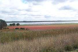 Samphire on the edges of Bool Lagoon in the Hundred of Robertson | |||||||||||||||
 Robe | |||||||||||||||
| Coordinates | 37°07′S 140°24′E / 37.11°S 140.40°ECoordinates: 37°07′S 140°24′E / 37.11°S 140.40°E[1] | ||||||||||||||
| Established | 23 July 1846[2] | ||||||||||||||
| Area | 5,080 square kilometres (1,962 sq mi)[1] | ||||||||||||||
| LGA(s) | |||||||||||||||
| |||||||||||||||
| Footnotes | Adjoining counties[1] | ||||||||||||||
The County of Robe is one of the 49 counties of South Australia. It was proclaimed by and named for Governor Frederick Robe in 1846.[1] It covers a portion of the state's south-east from the west coast at Robe all the way across to the border with Victoria on the east.[1] This includes the following contemporary local government areas of the state:[1]
- District Council of Robe
- Naracoorte Lucindale Council (excluding north third)
- Kingston District Council (small south portion)
- Wattle Range Council (small north portion)
Hundreds
The County of Robe is divided into the following 18 hundreds:
- Hundred of Mount Benson (Wangolina)
- Hundred of Bowaka (Reedy Creek)
- Hundred of Townsend (Avenue Range)
- Hundred of Joyce (Lucindale)
- Hundred of Spence (Spence)
- Hundred of Naracoorte (Naracoorte)
- Hundred of Jessie (Hynam)
- Hundred of Waterhouse (Robe)
- Hundred of Ross (Mount Benson)
- Hundred of Conmurra (Conmurra)
- Hundred of Robertson (Bool Lagoon)
- Hundred of Joanna (Joanna)
- Hundred of Bray (Bray)
- Hundred of Smith (Greenways)
- Hundred of Fox (Fox)
- Hundred of Coles (Coles)
- Hundred of Killanoola (Maaoupe)
- Hundred of Comaum (Coonawarra, Comaum)
References
- 1 2 3 4 5 6 7 8 9 10 "Search result for "County of Robe, Cnty" with the following layers selected - "Suburbs and Localities", "Local Government Areas", "Counties", "Hundreds", "Gazetteer", "Land Development Plan Zone Categories" and "SA Government Regions"". Location SA Map Viewer. Government of South Australia. Retrieved 25 February 2018.
- ↑ Mundy, A. M. (23 July 1846). "PROCLAMATION (re Counties of the Province of South Australia)" (PDF). South Australian Government Gazette. South Australian Government. p. 237. Retrieved 25 February 2018.
This article is issued from
Wikipedia.
The text is licensed under Creative Commons - Attribution - Sharealike.
Additional terms may apply for the media files.