Avenue Range, South Australia
| Avenue Range South Australia | |||||||||||||||
|---|---|---|---|---|---|---|---|---|---|---|---|---|---|---|---|
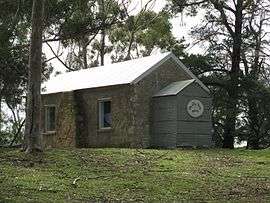 Former school building at Avenue Range | |||||||||||||||
 Avenue Range | |||||||||||||||
| Coordinates | 36°55′32″S 140°10′34″E / 36.925470°S 140.176110°ECoordinates: 36°55′32″S 140°10′34″E / 36.925470°S 140.176110°E | ||||||||||||||
| Established | 1998[1] | ||||||||||||||
| Postcode(s) | 5273[2] | ||||||||||||||
| Time zone | ACST (UTC+9:30) | ||||||||||||||
| • Summer (DST) | ACST (UTC+10:30) | ||||||||||||||
| Location |
| ||||||||||||||
| LGA(s) |
Kingston District Council Naracoorte Lucindale Council[1] | ||||||||||||||
| State electorate(s) | MacKillop[3] | ||||||||||||||
| Federal Division(s) | Barker[4] | ||||||||||||||
| |||||||||||||||
| |||||||||||||||
| Footnotes |
Coordinates[1] Locations[1] Climate[5] Adjoining localities[1] | ||||||||||||||
Avenue Range (formerly Downer) is a locality in the Australian state of South Australia located in the state's south-east within the Limestone Coast region about 265 kilometres (165 miles) south east of the Adelaide city centre.[1]
Its boundaries were created in 1998 for the “long established name” and include the former Government Town of Avenue which was surveyed in 1885 and proclaimed as Downer. The town was renamed as Downer in 1940.[1] Land within the locality is used exclusively for agriculture.[6][7]
Avenue was a stop on the Kingston-Naracoorte railway line which operated from 1876 until 1987. The Avenue school operated from 1903 until 1954.
The locality includes the Cairnbank Homestead and Shearing Shed, which is listed on the South Australian Heritage Register.[8]
Avenue Range is located within the federal Division of Barker, the state electoral district of MacKillop, and the local government areas of the Kingston District Council and the Naracoorte Lucindale Council.[1][3][4]
See also
References
- 1 2 3 4 5 6 7 8 "Search result for "Avenue Range (Locality Bounded)" (Record no SA0054134) with the following layers selected - "Suburbs and Localities", "Government Towns", and "Local Government Areas"". Department of Planning, Transport and Infrastructure. Archived from the original on 12 October 2016. Retrieved 12 April 2016.
- ↑ "Find a post - search result for Avenue Range, South Australia". postcodes-australia.com. Retrieved 12 April 2016.
- 1 2 "District of MacKillop Background Profile". Electoral Commission SA. Retrieved 12 April 2016.
- 1 2 "Federal electoral division of Barker" (PDF). Australian Electoral Commission. Retrieved 28 March 2016.
- ↑ "Monthly climate statistics: Summary statistics LUCINDALE POST OFFICE (nearest station)". Commonwealth of Australia , Bureau of Meteorology. Retrieved 12 April 2016.
- ↑ Development Plan- Naracoorte Lucindale Council, Consolidated – 29 November 2012 (PDF). Department of Planning, Transport and Infrastructure. 2012. pp. 10, 179 & 181.
- ↑ "NEW TOWN NAMES APPROVED". The Advertiser (Adelaide). South Australia. 26 July 1940. p. 10. Retrieved 5 September 2016 – via National Library of Australia.
- ↑ "Cairnbank Homestead & Shearing Shed". South Australian Heritage Register. Department of Environment, Water and Natural Resources. 10 April 1997. Retrieved 12 April 2016.
External links
