Coonawarra, South Australia
| Coonawarra South Australia | |||||||||||||||
|---|---|---|---|---|---|---|---|---|---|---|---|---|---|---|---|
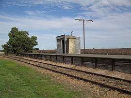 Coonawarra railway station, looking south | |||||||||||||||
 Coonawarra | |||||||||||||||
| Coordinates | 37°17′0″S 140°50′0″E / 37.28333°S 140.83333°ECoordinates: 37°17′0″S 140°50′0″E / 37.28333°S 140.83333°E[1] | ||||||||||||||
| Population | 137 (2016 census)[2] | ||||||||||||||
| Established | 13 December 2001 (locality)[3] | ||||||||||||||
| Postcode(s) | 5263[4] | ||||||||||||||
| Elevation | 59 m (194 ft) | ||||||||||||||
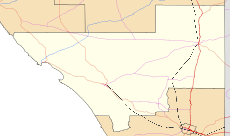
| Location |
| ||||||||||||||
| LGA(s) | Wattle Range Council | ||||||||||||||
| State electorate(s) | MacKillop | ||||||||||||||
| Federal Division(s) | Barker | ||||||||||||||
| |||||||||||||||
| |||||||||||||||
| Footnotes | Adjoining localities[1] | ||||||||||||||
Coonawarra is a small town north of Penola in South Australia. It is best known for the Coonawarra wine region named after it.
Coonawarra was a station on the Mount Gambier railway line[5] which opened in 1887 until it closed on 12 April 1995. The Limestone Coast Railway tourist trains occasionally stopped at the station in the early 2000s, but there has not been traffic on the line since then.
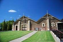
Wynns Coonawarra - Cellar Door
The township of Coonawarra is a few hundred metres west of the Riddoch Highway which passes along the ridge in the middle of the Coonawarra wine region. The historic Wynn's Coonawarra Winery in Memorial Drive is listed on the South Australian Heritage Register.[6]
References
| Wikimedia Commons has media related to Coonawarra, South Australia. |
- 1 2 "Search results for "Coonawarra, LOCB' with the following datasets selected – 'Suburbs and Localities', 'Counties", "Government Towns", "Local Government Areas", "SA Government Regions", "Railways", 'Hundreds', 'Roads' and 'Gazetteer'". Location SA Map Viewer. South Australian Government. Retrieved 27 February 2018.
- ↑ Australian Bureau of Statistics (27 June 2017). "Nangwarry (SSC) (State Suburb)". 2016 Census QuickStats. Retrieved 1 March 2016.

- ↑ Lawson, R. (13 December 2001). "GEOGRAPHICAL NAMES ACT 1991 Notice to Assign Boundaries and Names to Places (in the Wattle Range Council)" (PDF). The South Australian Government Gazette. South Australian Government. p. 5365. Retrieved 27 February 2018.
- ↑ Coonawarra Postcode Archived 30 December 2012 at Archive.is. Australia Post. Retrieved on 2008-05-25
- ↑ See Rail transport in South Australia#Southern narrow gauge lines for more information.
- ↑ "Wynn's Coonawarra Winery". South Australian Heritage Register. Department of Environment, Water and Natural Resources. Retrieved 26 August 2016.
This article is issued from
Wikipedia.
The text is licensed under Creative Commons - Attribution - Sharealike.
Additional terms may apply for the media files.