County of Way
| Way South Australia | |||||||||||||||
|---|---|---|---|---|---|---|---|---|---|---|---|---|---|---|---|
.jpg) | |||||||||||||||
 Way | |||||||||||||||
| Coordinates | 31°51′S 133°40′E / 31.850°S 133.667°ECoordinates: 31°51′S 133°40′E / 31.850°S 133.667°E | ||||||||||||||
| Area | 6,800 km2 (2,610 sq mi)[1] | ||||||||||||||
| LGA(s) | District Council of Ceduna | ||||||||||||||
| |||||||||||||||
The County of Way is one of the 49 counties of South Australia on the state's west coast.[1] It was proclaimed circa 1889 by Governore William Robinson and named for Samuel Way, the Chief Justice of the state's Supreme Court at the time.[1]
It covers a portion of the state's west coast from Acraman Creek Conservation Park, just west of Streaky Bay, to Watraba, about 53 kilometres (33 mi) west of Ceduna[1] The northern half of the county spans most of the Yumbarra Conservation Park.
Hundreds
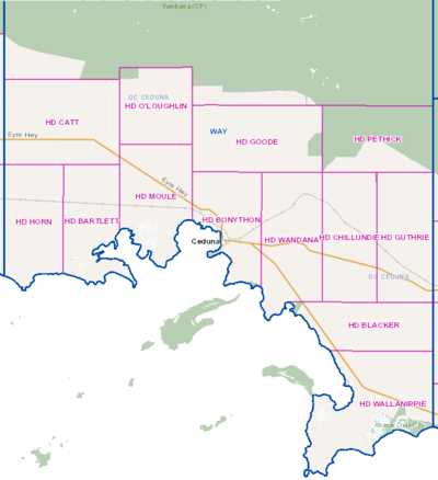
Map of the southern part of the County of Way showing hundred divisions
The County of Way contains the following 13 hundreds, covering approximately the southern half of its total area:
- Hundred of Horn, established 1889 (Charra)
- Hundred of Catt, established 1889 (Watraba, White Well Corner, Koonibba, Uworra)
- Hundred of Bartlett (Charra)
- Hundred of Moule, established 1889 (Nadia, Denial Bay)
- Hundred of O'Loughlin, established 1896 (Koonibba, Kalanbi)
- Hundred of Bonython, established 1893 (Ceduna)
- Hundred of Goode, established 1893 (Kalanbi, Wandana)
- Hundred of Wandana, established 1893 (Wandana, Merghiny, Laura Bay)
- Hundred of Blacker, established 1893 (Laura Bay, Mudamuckla, Puntabie)
- Hundred of Chillundie, established 1893 (Maltee, Merghiny, Mudamuckla)
- Hundred of Guthrie, established 1893 (Mudamuckla, Puntabie)
- Hundred of Pethick, established 1929 (Pureba
- Hundred of Wallanippie, established 1893 (Smoky Bay)
References
- 1 2 3 4 "Placename Details: County of Dufferin". Property Location Browser. Government of South Australia. SA0020117. Retrieved 23 October 2017.
Derivation of Name: Chief Justice Samuel J Way; Other Details: Area 2610 square miles. Located 31:51S, 133:40E. The Right Sir Samuel James Way, Baronet, P.C. & Chief Justice.
This article is issued from
Wikipedia.
The text is licensed under Creative Commons - Attribution - Sharealike.
Additional terms may apply for the media files.