County Route 526 (New Jersey)
| ||||
|---|---|---|---|---|
_map.svg.png) CR 526 highlighted in red | ||||
| Route information | ||||
| Maintained by Mercer County, West Windsor Township, NJDOT, Monmouth County, Ocean County | ||||
| Length | 35.56 mi[1] (57.23 km) | |||
| Tourist routes | Upper Freehold Historic Farmland Byway | |||
| Major junctions | ||||
| West end |
| |||
| ||||
| East end |
| |||
| Location | ||||
| Counties | Mercer, Monmouth, Ocean | |||
| Highway system | ||||
| ||||

County Route 526, abbreviated CR 526, is a county highway in the U.S. state of New Jersey. The highway extends 35.56 miles (57.23 km) from Princeton–Hightstown Road (CR 571) in West Windsor Township to Lanes Mill Road (CR 549) in Lakewood Township.
Despite the official ending at CR 571 in West Windsor, most signs show it concurrent with 571 to its end at state Route 27 in Princeton.
Route description
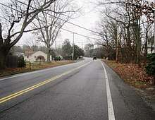
_just_west_of_Indian_Lake_in_Robbinsville_Township%2C_Mercer_County%2C_New_Jersey.jpg)
CR 526 officially begins at an intersection with CR 571 in West Windsor Township, Mercer County, heading south on two-lane undivided South Mill Road. Although the official western terminus is here, signage for CR 526 continues northwest along CR 571 to Route 27 in Princeton. From CR 571, the route passes through residential subdivisions. At Woodmere Way, the road's jurisdiction changes from county to municipal where it curves east and then south on New Edinburg Road with a median. The road crosses CR 644 where county maintenance resumes and continues south, with the center line narrowing past the New Village Road intersection.[2] CR 526 intersects CR 535 and CR 641, turning west for a brief concurrency with CR 535 on Old Trenton Road before heading south on Robbinsville Road. The route into agricultural areas and enters Robbinsville Township, eventually heading into a mix of farms, woods, and homes. Farther south, the road passes through housing subdivisions before turning southeast for a brief concurrency with Route 33 prior to following Robbinsville-Allentown Road. Here, CR 526 passes businesses and crosses an abandoned railroad line before coming to U.S. Route 130 (US 130). The route officially turns northeast for a brief concurrency with US 130 on a four-lane divided highway before resuming east on two-lane undivided Robbinsville Bypass. The former alignment of Robbinsville-Allentown Road between US 130 and the Robbinsville Bypass is also officially signed as CR 526 and maintained by Mercer County.[2] The road curves south and then southeast as it heads into residential areas. CR 526 passes over the New Jersey Turnpike (Interstate 95 or I-95) before turning south near warehouses and coming to an interchange with I-195. South of this interchange, the route heads through a mix of farmland and woodland, curving southeast.[1][3]
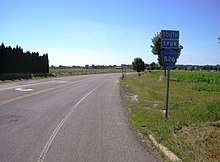
_near_Indian_Run_in_Allentown%2C_New_Jersey.JPG)
CR 526 continues into Allentown in Monmouth County and passes homes before it forms a short concurrency with CR 524 and CR 539 on Main Street. From this point, the route continues east through residential areas on Waker Avenue, leaving Allentown for Upper Freehold Township. First, the road intersects CR 526 Alternate (CR 526 Alt.) which provides a bypass of Allentown for traffic to and from I-195. In this area, the road passes farms to the north and homes to the south as it intersects CR 526 Spur. CR 526 heads straight through a mix of farmland and woodland with a few areas of development, passing through open areas of farms prior to crossing Sharon Station Road (CR 539 Alt.), the Union Transportation Trail (formerly Pemberton and Hightstown Railroad), and CR 43, which loops to the south of CR 526 and intersects it again a short distance later. The route passes agricultural areas to the north and woodland to the south before running through a mix of farms, woods, and residences. The road passes Red Valley Lake and heads into Millstone Township, becoming Trenton-Lakewood Road and turning to the northeast. CR 526 passes over I-195 and curves east into more wooded areas before intersecting CR 571 again in developed areas. At this point, CR 526 turns south to run concurrent with CR 571, passing through forested areas with a few homes.[1][3]
Upon crossing CR 537, the road enters Jackson Township in Ocean County and continues through more forests, passing under I-195 before CR 526 splits from CR 571 by turning east onto West Commodore Boulevard. The road passes through more wooded areas of development, with the forests becoming more dense as the route comes to CR 527. At this intersection, CR 526 becomes East Commodore Boulevard and passes near more forested areas of homes before briefly joining CR 638 and becoming Jackson Mills Road. The road passes through wooded areas with some farms and development, with the road name changing to County Line Road. CR 526 heads southeast into increasing residential and commercial development as it widens into a four-lane divided highway with jughandles as it approaches the CR 636 junction. The route passes several businesses before becoming the border between Jackson Township to the northeast and Lakewood Township to the southwest as it intersects CR 641 and becomes a four-lane undivided road. The road heads into more residential surroundings as it fully enters Lakewood Township, intersecting CR 639 before curving to the east and coming to the US 9 junction. Past this intersection, CR 526 narrows to two lanes and passes more homes as it heads to the CR 547 junction. The route crosses Conrail Shared Assets Operations' Southern Secondary line and passes more areas of homes and businesses before entering morw wooded areas of development and turning southeast to meet CR 623. At this point, the name of the road changes to Lanes Mill Road and it passes more residential areas before CR 526 comes to its eastern terminus at CR 549.[1][3]
Major intersections
| County | Location | mi[1] | km | Destinations | Notes |
|---|---|---|---|---|---|
| Mercer | West Windsor Township | 0.00 | 0.00 | Western terminus, signage continues along CR 571 | |
| 3.42 | 5.50 | West end of CR 535 overlap | |||
| 3.84 | 6.18 | East end of CR 535 overlap | |||
| Robbinsville Township | 6.58 | 10.59 | West end of Route 33 overlap | ||
| 6.61 | 10.64 | East end of Route 33 overlap | |||
| 6.88 | 11.07 | West end of US 130 overlap | |||
| 7.02 | 11.30 | East end of US 130 overlap | |||
| 9.35 | 15.05 | Exit 7 (I-195); no access to eastbound I-195 from westbound CR 526 | |||
| Monmouth | Allentown | 10.50 | 16.90 | West end of CR 524/CR 539 overlap | |
| 10.52 | 16.93 | East end of CR 524/CR 539 overlap | |||
| Upper Freehold Township | 10.98 | 17.67 | Southern terminus of CR 526 Spur | ||
| 12.82 | 20.63 | Northern terminus of CR 539 Alt. | |||
| Millstone Township | 19.49 | 31.37 | West end of CR 571 overlap | ||
| Monmouth–Ocean county line | Millstone–Jackson township line | 20.07 | 32.30 | ||
| Ocean | Jackson Township | 20.96 | 33.73 | East end of CR 571 overlap | |
| 24.33 | 39.16 | ||||
| Lakewood Township | 31.73 | 51.06 | |||
| 32.49 | 52.29 | ||||
| 35.56 | 57.23 | Eastern terminus | |||
1.000 mi = 1.609 km; 1.000 km = 0.621 mi
| |||||
CR 526 Spur
| |
|---|---|
| Location | Upper Freehold Township |
| Length | 0.44 mi[4][5] (0.71 km) |
| Existed | 2003–present |
County Route 526 Spur (CR 526 Spur) is a county highway in the U.S. state of New Jersey. Completed in 2003 and entirely within Upper Freehold Township, it is known as the Allentown Bypass, as it allows through traffic to bypass the Borough of Allentown.[6] The highway extends 0.44-mile (0.71 km) from Allentown - Red Valley Road (CR 526) to Old York Road (CR 524 and CR 539).[4][7] It is two lanes wide; a farm mostly lines the west side of the road while the east side has the Reed Recreation Area; the only place accessible from the road itself.[8] The road was briefly signed as CR 526 Alternate in early 2018.
- External links

See also


References
- 1 2 3 4 5 "County Route 526 straight line diagram" (PDF). Trenton, New Jersey: New Jersey Department of Transportation. 2009. Retrieved January 5, 2011.
- 1 2 "County Routes and Roadways". Mercer County Department of Transportation and Infrastructure - Highway Division. Retrieved June 30, 2018.
- 1 2 3 Google (January 8, 2011). "overview of County Route 526" (Map). Google Maps. Google. Retrieved January 8, 2011.
- 1 2 NJDOT County Route 526 Alternate Straight Line Diagram (PDF) (NJDOT) (Straight line diagram)
- ↑ "Monmouth County Road Plan" (PDF). Monmouth County Planning Board. October 15, 2012. Retrieved April 6, 2018.
- ↑ Degnan, Joanne (May 30, 2012). "ALLENTOWN: Heavy truck traffic rattles Church Street residents". The Messenger-Press. Retrieved April 6, 2018 – via centraljersey.com.
In 2003, the county built a bypass off Route 526 in Upper Freehold near the Hope Fire Company and Reed Park that directs traffic around the north end of Allentown to Exit 8 of I-195.
- ↑
- County Roads Straight Line Diagrams, Prepared by the Monmouth County Planning Board, April 10, 2006
- ↑ Google (April 6, 2018). "CR 526 Alternate overview" (Map). Google Maps. Google.
External links
Route map:
| Wikimedia Commons has media related to County Route 526 (New Jersey). |