Conyers, Georgia
| Conyers, Georgia | |
|---|---|
| City | |
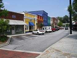 Olde Town Conyers | |
| Nickname(s): C-Town | |
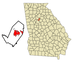 Location in Rockdale County and the state of Georgia | |
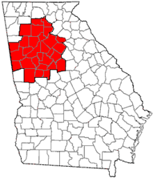
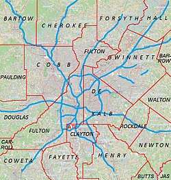 Conyers Location of Conyers in Metro Atlanta | |
| Coordinates: 33°39′59″N 84°0′27″W / 33.66639°N 84.00750°WCoordinates: 33°39′59″N 84°0′27″W / 33.66639°N 84.00750°W | |
| Country | United States |
| State | Georgia |
| County | Rockdale |
| Area | |
| • Total | 11.9 sq mi (30.9 km2) |
| • Land | 11.8 sq mi (30.5 km2) |
| • Water | 0.1 sq mi (0.4 km2) |
| Elevation | 899 ft (274 m) |
| Population (2010) | |
| • Total | 15,195 |
| • Estimate (2016)[1] | 15,919 |
| • Density | 1,300/sq mi (490/km2) |
| Time zone | UTC-5 (Eastern (EST)) |
| • Summer (DST) | UTC-4 (EDT) |
| ZIP codes | 30012, 30013, 30094 |
| Area code(s) | 470/678/770 |
| FIPS code | 13-19336[2] |
| GNIS feature ID | 0312910[3] |
| Website | City of Conyers official website |
Conyers is the only city in Rockdale County, Georgia, United States. The city is twenty-four miles (38.6 km) east of Atlanta. As of the 2010 census, the city population was 15,195. The city is the county seat of Rockdale County.[4] The formerly separate town of Milstead is now part of Conyers.
History
Before European settlement, the area which is now Conyers, along with the surrounding county of Rockdale, was occupied by mound-building Native Americans. As time progressed, the Muscogee (or Creek) and Cherokee natives shared a common border here. This border was known as the "Great Indian Road," and is known now as the "Hightower Trail". This trail was used by white settlers following the American Revolution.

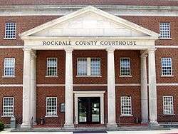
Between 1816 and 1821, the area known as Rockdale was open for settlement. John Holcomb, a blacksmith, was the first settler in what is now Conyers. He settled where the current Rockdale County Courthouse is located, in the middle of Conyers on Main Street.
Eventually, there was pressure for a railroad to cross Georgia; the railroad was intended to run from Augusta, through neighboring Covington to Marthasville (now known as Atlanta). John Holcomb was against the railroad and refused to sell his land, and threatened to shoot anyone from the railroad who came onto his property.
Dr. W. D. Conyers, a banker from Covington, eventually persuaded John Holcomb into selling his land for $700. Dr. Conyers then sold the land to the Georgia Railroad. What is now Conyers began as a watering post along this line, named after Dr. Conyers. By 1845, the railroad was in full operation. By 1854, nearly 400 residents lived around the watering post, and Conyers was incorporated.
Conyers has been nearly destroyed several times by fire. It is said that it survived Sherman's March to the Sea thanks to a friend of Sherman's who lived in the area between Conyers and Covington. The story goes that the houses were spared because Sherman was uncertain where his friend lived.
In 1870, the surrounding area was incorporated into Rockdale County out of Newton County, Georgia, and Conyers became the county seat.
Over the next decade, Conyers grew into a wild town. It had twelve saloons and five brothels. The more reputable side of the town had 40 stores, Conyers College, a hotel, a carriage manufacturer and good schools.
The Conyers post office contains a mural, The Ploughman, painted in 1940 by Elizabeth Terrell. Murals were produced from 1934 to 1943 in the United States through the Section of Painting and Sculpture, later called the Section of Fine Arts, of the Treasury Department. The WPA was the largest and most ambitious American New Deal agency, employing individuals to carry out public works projects.[5]
Conyers was also home to "sidewalk churches". Along Main Street grew First Methodist, Conyers Presbyterian, and First Baptist. It is said that at some point the congregants persuaded the brothels and saloons to close and leave Conyers for Covington, having persuaded them with a mob. This rose out of revivals began in 1878 with the Methodist and Presbyterian churches. First Baptist Church of Conyers moved out of downtown in late 2000, moving about two miles or three kilometers south of the Georgia International Horse Park to their current location.
Tightly connected to Conyers is Milstead, a mill town now incorporated into Conyers. At its peak, Milstead and Conyers had a private railroad which delivered products, such as cotton, from the mill to Conyers for shipping to the textile mills. In the 1960s, the mill closed.
In 1944, a Trappist monastery (a Catholic order), Abbey of the Holy Spirit, was established south of the city by Dom Frederic Dunne. The Protestant community of Rockdale County helped with the completing of the current structure. M. Basil Pennington, one of the founders of the Centering Prayer movement, was abbot of the monastery from 2000 to 2002.
In the 1950s, Conyers had a Coca-Cola bottling facility. In 1957, Lithonia Lighting moved from Lithonia.
In the 1960s, Interstate 20 was built through the county. Gus Barksdale, Clarence Vaughn, Roland Reagan, and Harry Downs helped establish the community for the future by pushing for business expansion.
In the 1970s, parts of the first five episodes of the Dukes of Hazzard were filmed in the town.
In the 1980s, Conyers became known for "White Road", where resident Nancy Fowler claimed to have seen apparitions of the Virgin Mary. Throughout the late 1980s and early 1990s, Conyers played host to pilgrims.
In the early 1990s, several scenes of In the Heat of the Night were filmed around the Conyers Depot. Alan Autry, who played the character of Captain Bubba Skinner, was seen as a regular around Conyers during the filming.
In 1996 Conyers hosted the equestrian and mountain biking events for the 1996 Olympic Games held in Atlanta. For this, Conyers built the Georgia International Horse Park.
On 20 May 1999 a school shooting took place known as the Heritage High School shooting. Six students were injured before the 15-year-old gunman surrendered to the police.
In October 1999 Rockdale County, and by extension the county seat of Conyers gained substantial notoriety when the Public Broadcasting Service series Frontline aired a nationwide documentary entitled The Lost Children of Rockdale County detailing a syphilis outbreak among middle and high school aged teenagers within the county.[6] The documentary was well received outside Conyers, with rave reviews from such outlets as the Wall Street Journal and Entertainment Weekly; Interviewed by Oprah Winfrey.[7]
In 2010, Conyers was thrust into the spotlight when identical twins and former residents Tasmiyah Janeesha Whitehead and Jasmiyah Kaneesha Whitehead (both born 27 November 1993) were arrested on 21 May 2010 for having committed matricide. The victim was Jarmecca Yvonne Whitehead (born 18 April 1975) who also went by the nickname "Nikki". She was beaten and stabbed and placed in a tub full of water where her daughters left her to die as they left for Rockdale County High School. The crime occurred on 13 January 2010 in the Bridle Ridge Walk subdivision on Appaloosa Way. The crime sent shockwaves throughout the community. Jarmecca's autopsy revealed that she suffered injuries to her lungs, jugular vein and had a severed spinal cord. Initially the twins proclaimed their innocence but in 2014 the twins pleaded guilty and are serving 30-year sentences each in separate prisons. The crime was heavily documented by the news media and by journalists. The crime was featured in a few true crime documentaries and true crime television shows which include Dateline NBC in an episode titled "Bad Blood", Snapped episode 1403 titled "The Whitehead Twins" and Evil Twins in an episode titled "Honor Roll Killers". a show that airs on the Investigation Discovery network (see also Murder of Nikki Whitehead).[8]
As of 2013, the CW show The Originals began filming in Conyers.
Geography
Conyers is located at 33°39′59″N 84°0′27″W / 33.66639°N 84.00750°W (33.666360, −84.007574).[9]
According to the United States Census Bureau, the city has a total area of 11.9 square miles (31 km2), of which 11.8 square miles (31 km2) is land and 0.1 square miles (0.26 km2) (1.17%) is water.
Demographics
| Historical population | |||
|---|---|---|---|
| Census | Pop. | %± | |
| 1870 | 637 | — | |
| 1880 | 1,374 | 115.7% | |
| 1890 | 1,349 | −1.8% | |
| 1900 | 1,605 | 19.0% | |
| 1910 | 1,919 | 19.6% | |
| 1920 | 1,817 | −5.3% | |
| 1930 | 1,495 | −17.7% | |
| 1940 | 1,619 | 8.3% | |
| 1950 | 2,003 | 23.7% | |
| 1960 | 2,881 | 43.8% | |
| 1970 | 4,890 | 69.7% | |
| 1980 | 6,567 | 34.3% | |
| 1990 | 7,380 | 12.4% | |
| 2000 | 10,689 | 44.8% | |
| 2010 | 15,195 | 42.2% | |
| Est. 2016 | 15,919 | [1] | 4.8% |
| U.S. Decennial Census[10] | |||
As of the census[2] of 2010, there were 15,195 people, 5,661 households, and 3,642 families residing in the city. The population density was 907.3 people per square mile (350.3/km²). There were 4,183 housing units at an average density of 355.1 per square mile (137.1/km²). The racial makeup of the city was 24.3% White, 55.8% African American, 0.2% Native American, 1.4% Asian, 0.1% Pacific Islander, 0.4% from other races, and 1.5% from two or more races. Hispanic or Latino of any race were 16.3% of the population.
There were 3,910 households out of which 34.2% had children under the age of 18 living with them, 37.5% were married couples living together, 21.0% had a female householder with no husband present, and 34.6% were non-families. 26.4% of all households were made up of individuals and 7.9% had someone living alone who was 65 years of age or older. The average household size was 2.67 and the average family size was 3.17.
In the city, the population was spread out with 27.3% under the age of 18, 12.6% from 18 to 24, 33.1% from 25 to 44, 17.4% from 45 to 64, and 9.6% who were 65 years of age or older. The median age was 30 years. For every 100 females, there were 94.5 males. For every 100 females age 18 and over, there were 91.1 males.
The median income for a household in the city was $35,789, and the median income for a family was $38,255. Males had a median income of $29,991 versus $24,879 for females. The per capita income for the city was $15,805. About 13.7% of families and 16.9% of the population were below the poverty line, including 24.5% of those under age 18 and 9.1% of those age 65 or over.
Education
The Rockdale County School District holds pre-school to grade twelve, and consists of eleven elementary schools, four middle schools, three high schools, and one career academy.[11] The district has 889 full-time teachers and over 13,801 students.[12]
Sports
Georgia Revolution FC is a semi-professional soccer team based in Conyers, Georgia. The team was founded in 2010 and is a member of the South Atlantic Conference of the National Premier Soccer League (NPSL), the fourth tier of the American soccer pyramid. Games are played in the summer months at the Rockdale Youth Soccer Association.
Notable people
- Tyler Austin, MLB baseball player for the Minnesota Twins
- Jill Arrington, sports anchor at KCBS-TV, formerly with Fox Sports 1 and CBS Sports
- Billy Buckner, MLB pitcher
- Jesse Baker, former NFL defensive end with the Houston Oilers and Dallas Cowboys
- Jerome Boger, NFL referee
- David Elder, former MLB player
- Dakota Fanning, actress
- Elle Fanning, actress
- Candace Hill, 100m and 200m sprint IAAF World Youth Championship winner
- Hansi Holloway, former Miss NC Plus America 2003 for Miss Plus America Pageant, model, and writer
- Holly Hunter, actress
- Keasha Lee, actress, founder of New Gains Academy
- Grady Jarrett, NFL player for the Atlanta Falcons
- A. D. Jenkins singer-songwriter Cutter J
- Ben L. Jones, "Crazy" Cooter Davenport in The Dukes of Hazzard and politician
- DeForest Kelley, Dr. Leonard "Bones" McCoy, of TV's Star Trek: The Original Series
- Ashley Scott, artist and writer
- Matt Kennon, singer
- Clint Mathis, World Cup soccer player
- Jack McBrayer, actor
- James C. Miller III, former U.S. government official and economist
- Cartel's Will Pugh, Joseph Pepper, Nic Hudson, Kevin Sanders, and Ryan Roberts
- Scott Russell, WSBK Champion, 5-time Daytona Winner
- Silentó, rapper
- Marion Tinsley, checkers expert
- Dave Willis, co-creator of Aqua Teen Hunger Force and Squidbillies
- Gorilla Zoe, rapper
- Janice Shaw Crouse
References
- 1 2 "Population and Housing Unit Estimates". Retrieved 9 June 2017.
- 1 2 "American FactFinder". United States Census Bureau. Archived from the original on 11 September 2013. Retrieved 2008-01-31.
- ↑ "US Board on Geographic Names". United States Geological Survey. 25 October 2007. Retrieved 2008-01-31.
- ↑ "Find a County". National Association of Counties. Archived from the original on 31 May 2011. Retrieved 2011-06-07.
- ↑ Arnesen, Eric (2007). Encyclopedia of U.S. Labor and Working-Class History. 1. New York: Routledge. p. 1540. ISBN 9780415968263.
- ↑ "Synopsis - The Lost Children Of Rockdale County - FRONTLINE - PBS". www.pbs.org. Retrieved 2 April 2018.
- ↑ "Press - The Lost Children Of Rockdale County - FRONTLINE - PBS". www.pbs.org. Retrieved 2 April 2018.
- ↑ "Update: Jarmecca "Nikki" Whitehead murder *Daughters, Jasmiyah and Tasmiyah Whitehead, pled guilty, sentenced to 30 years in prison*". wordpress.com. 2 August 2014. Retrieved 2 April 2018.
- ↑ "US Gazetteer files: 2010, 2000, and 1990". United States Census Bureau. 12 February 2011. Retrieved 2011-04-23.
- ↑ "Census of Population and Housing". Census.gov. Archived from the original on 12 May 2015. Retrieved 4 June 2015.
- ↑ Georgia Board of Education, Retrieved 26 June 2010.
- ↑ School Stats, Retrieved 26 June 2010.
External links
- City of Conyers official website
- Rockdale County Historical Society
- Georgia International Horse Park website
- Cherokee Run Golf Club website
- Monastery of the Holy Spirit, Conyers, Georgia
- Walk of Heroes Veteran War Memorial, Conyers, Georgia
- New Gains Academy
- Historic District – Olde Town Conyers, Georgia
- Conyers Rockdale Chamber of Commerce website
- Conyers Rockdale Economic Development Council website
- Georgia State Park – Panola Mountain located in South Rockdale County
- Arabia Mountain National Heritage Area website
- Conyers Rockdale Library – The Nancy Guinn Memorial Library website
- Film Rockdale – A Camera Ready Community
- March to the Sea Heritage Trail
- PATH Foundation – Olde Town Conyers Trail
- Rockdale County official website
- Rockdale County Public Schools official website
- Rockdale Tennis Center website
- Rockdale Youth Soccer Association website
|  | |||||
|
| ||||||
| ||||||
Municipalities and communities of Rockdale County, Georgia, United States | ||
|---|---|---|
| City | 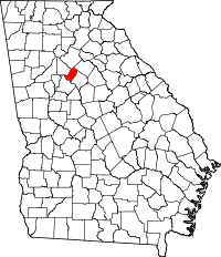 | |
| CDP | ||