Conquest, New York
| Conquest, New York | |
|---|---|
| Town | |
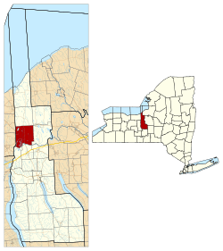 Location within Cayuga County and New York | |
 Conquest Location within the state of New York | |
| Coordinates: 43°6′32″N 76°39′13″W / 43.10889°N 76.65361°W | |
| Country | United States |
| State | New York |
| County | Cayuga |
| Government | |
| • Type | Town Council |
| • Town Supervisor | Charles M. Knapp (D) |
| • Town Council |
Members' List
|
| Area[1] | |
| • Total | 36.32 sq mi (94.06 km2) |
| • Land | 35.22 sq mi (91.22 km2) |
| • Water | 1.10 sq mi (2.84 km2) |
| Elevation | 420 ft (128 m) |
| Population (2010) | |
| • Total | 1,819 |
| • Estimate (2016)[2] | 1,745 |
| • Density | 49.54/sq mi (19.13/km2) |
| Time zone | UTC-5 (Eastern (EST)) |
| • Summer (DST) | UTC-4 (EDT) |
| ZIP code | 13140 |
| Area code(s) | 315 |
| FIPS code | 36-011-17849 |
| GNIS feature ID | 0978862 |
| Website |
www |
Conquest is a town in Cayuga County, New York, United States. The population was 1,819 at the 2010 census.[3] The name was chosen to mark the victory of those who wished to form the town. Conquest is on the western border of Cayuga County and is west of Syracuse.
History
Conquest was part of the Central New York Military Tract. The area of the town was first settled around 1800. The town of Conquest was formed in 1821 from the town of Cato after a contentious dispute about whether to form the new town. The town of Victory was formed at the same time and given a name to celebrate the outcome.
Geography
According to the United States Census Bureau, the town of Conquest has a total area of 36.3 square miles (94.1 km2), of which 35.2 square miles (91.2 km2) is land and 1.1 square miles (2.8 km2), or 3.02%, is water.[3]
The west town line is the border of Wayne County, and the Seneca River and the Erie Canal define the south town line.
New York State Route 38 is a north-south highway in Conquest.
Demographics
| Historical population | |||
|---|---|---|---|
| Census | Pop. | %± | |
| 1830 | 1,507 | — | |
| 1840 | 1,911 | 26.8% | |
| 1850 | 1,862 | −2.6% | |
| 1860 | 1,892 | 1.6% | |
| 1870 | 1,821 | −3.8% | |
| 1880 | 1,661 | −8.8% | |
| 1890 | 1,549 | −6.7% | |
| 1900 | 1,360 | −12.2% | |
| 1910 | 1,103 | −18.9% | |
| 1920 | 1,044 | −5.3% | |
| 1930 | 906 | −13.2% | |
| 1940 | 890 | −1.8% | |
| 1950 | 1,103 | 23.9% | |
| 1960 | 1,170 | 6.1% | |
| 1970 | 1,362 | 16.4% | |
| 1980 | 1,628 | 19.5% | |
| 1990 | 1,859 | 14.2% | |
| 2000 | 1,925 | 3.6% | |
| 2010 | 1,819 | −5.5% | |
| Est. 2016 | 1,745 | [2] | −4.1% |
| U.S. Decennial Census[4] | |||
As of the census[5] of 2000, there were 1,925 people, 665 households, and 514 families residing in the town. The population density was 54.7 people per square mile (21.1/km²). There were 847 housing units at an average density of 24.1 per square mile (9.3/km²). The racial makeup of the town was 98.34% White, 0.26% African American, 0.42% Native American, 0.05% Asian, 0.10% from other races, and 0.83% from two or more races. Hispanic or Latino of any race were 0.36% of the population.
There were 665 households out of which 38.6% had children under the age of 18 living with them, 62.7% were married couples living together, 7.8% had a female householder with no husband present, and 22.6% were non-families. 15.9% of all households were made up of individuals and 6.0% had someone living alone who was 65 years of age or older. The average household size was 2.89 and the average family size was 3.19.
In the town, the population was spread out with 29.0% under the age of 18, 7.7% from 18 to 24, 30.4% from 25 to 44, 23.4% from 45 to 64, and 9.5% who were 65 years of age or older. The median age was 36 years. For every 100 females, there were 101.8 males. For every 100 females age 18 and over, there were 102.2 males.
The median income for a household in the town was $37,857, and the median income for a family was $41,583. Males had a median income of $30,882 versus $21,923 for females. The per capita income for the town was $15,045. About 7.6% of families and 12.4% of the population were below the poverty line, including 19.9% of those under age 18 and 9.0% of those age 65 or over.
Communities and locations in Conquest
- Conquest (formerly "Conquest Center") – The hamlet of Conquest is near the center of the town on NY-38. The community was founded around 1802.
- Cottage Corners – A location on NY-38, south of Conquest village.
- Duck Lake – A lake in the northwest part of the town.
- Emerson (formerly called "The Pepper Mill") – a hamlet in the southeast part of the town.
- Hard Point – A hamlet in the southwest part of the town by the Seneca River.
- Haiti Island – An island in the Seneca River west of NY-38.
- Howland – A hamlet in the southwest corner of the town in the wildlife management area on Howland Island.
- Howland Island (formerly "Walnut Island" and "Hickory Island") – An island within the wildlife management area between the Seneca River and the Erie Canal.
- Montezuma Swamp Wildlife Management Area – A conservation area in the southwest corner of the town partly bounded by the Seneca River and the Erie Canal.
- Mosquito Point – A location near the south town line on the east end of Haiti Island.
- Spring Lake (formerly "Pineville" until 1874) – A hamlet west of Conquest village.
References
- ↑ "2016 U.S. Gazetteer Files". United States Census Bureau. Retrieved Jul 4, 2017.
- 1 2 "Population and Housing Unit Estimates". Retrieved June 9, 2017.
- 1 2 "Geographic Identifiers: 2010 Demographic Profile Data (G001): Conquest town, Cayuga County, New York". U.S. Census Bureau, American Factfinder. Retrieved November 12, 2014.
- ↑ "Census of Population and Housing". Census.gov. Archived from the original on May 12, 2015. Retrieved June 4, 2015.
- ↑ "American FactFinder". United States Census Bureau. Archived from the original on 2013-09-11. Retrieved 2008-01-31.
External links
Coordinates: 43°07′16″N 76°38′53″W / 43.12111°N 76.64806°W
Municipalities and communities of Cayuga County, New York, United States | ||
|---|---|---|
| City | 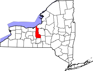 | |
| Towns | ||
| Villages | ||
| CDP | ||
| Other hamlets | ||
| Footnotes | ‡This populated place also has portions in an adjacent county or counties | |