Ciénega Bridge
| Ciénega Bridge | |
|---|---|
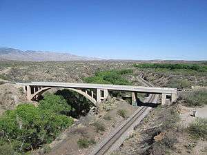 View of the Ciénega Bridge from the top of Marsh Station Bridge, facing east. The Rincon Mountain range are in the background at the left. | |
| Coordinates | 32°01′11″N 110°38′46″W / 32.01972°N 110.64611°WCoordinates: 32°01′11″N 110°38′46″W / 32.01972°N 110.64611°W |
| Carries |
Marsh Station Road, pedestrians and bicycles |
| Crosses | Ciénega Creek |
| Locale | Pima County, Arizona, USA |
| Characteristics | |
| Design | Open-spandrel arch |
| Total length | 277.9 ft (85 m) |
| Width | 21.7 ft (7 m) |
| Longest span | 146 ft (45 m) |
| History | |
| Construction start | 1920 |
| Construction end | 1921 |
Ciénega Bridge is an open-spandrel arch bridge which crosses Pantano Wash near Vail, Arizona.[1] Construction was started in 1920 by the Arizona Highway Department. The Highway Department received financial aid from the federal government as well as Pima and Cochise counties. The bridge was completed in 1921 at a total cost of $40,000.[2] Starting in 1926, the bridge carried U.S. Route 80, a transcontinental highway which stretched from Tybee Island, Georgia to San Diego, California.[3][2] In 1956, US 80 was rerouted to a new route south of the bridge.[4] US 80 was replaced by Interstate 10 in 1977.[3] The Ciénega Bridge was added to the National Register of Historic Places on September 30, 1988.[1] The bridge along with Marsh Station Road was designated as part of Historic U.S. Route 80 by the Arizona Department of Transportation on September 21, 2018.[5]
See also

- List of bridges on the National Register of Historic Places in Arizona
- National Register of Historic Places listings in Pima County, Arizona
References
- 1 2 "Bridgehunter.com - Cienega Bridge". Retrieved 2014-04-05.
- 1 2 State of Arizona (31 October 2004). "Historic Property Inventory Forms - Pima County Bridges" (PDF). Inventory Records. Arizona Department of Transportation (ADOT). Retrieved 29 August 2018.
- 1 2 Weingroff, Richard F. (October 17, 2013). "U.S. Route 80: The Dixie Overland Highway". Highway History. Federal Highway Administration. Retrieved April 1, 2015.
- ↑ Shell Oil Company; H.M. Gousha Company (1956). Shell Highway Map of Arizona (Map). 1:1,330,560. Chicago: Shell Oil Company. Retrieved March 31, 2015 – via David Rumsey Map Collection.
- ↑ "Historic Arizona U.S. Route 80 Designation". Webpage. Tucson Historic Preservation Foundation. August 2017. Retrieved 23 August 2018.
External links
 |  | ||
