Chapin, Wisconsin
| Chapin, Wisconsin | |
|---|---|
| Unincorporated community | |
 Chapin, Wisconsin  Chapin, Wisconsin | |
| Coordinates: 42°37′17″N 87°58′22″W / 42.62139°N 87.97278°WCoordinates: 42°37′17″N 87°58′22″W / 42.62139°N 87.97278°W | |
| Country | United States |
| State | Wisconsin |
| County | Kenosha |
| Time zone | UTC-6 (Central (CST)) |
| • Summer (DST) | UTC-5 (CDT) |
| Area code(s) | 262 |
Chapin is a small residential and agricultural unincorporated community in the town of Paris, Kenosha County, Wisconsin, United States. It is centered at Highway 142 (Burlington Road) near what is currently Kenosha County Highway MB.[1] The community was settled in the 19th Century and has also been known as Star Corners, Heidersdorf's Corner, Jugville (it was the site of the area's first tavern), and Parisville.[2]
Notes
Municipalities and communities of Kenosha County, Wisconsin, United States | ||
|---|---|---|
| City | 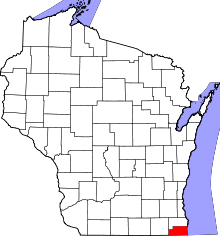 | |
| Villages | ||
| Towns | ||
| CDPs | ||
| Unincorporated communities | ||
| Ghost town/neighborhood | ||
| Footnotes | ‡This populated place also has portions in an adjacent county or counties | |
This article is issued from
Wikipedia.
The text is licensed under Creative Commons - Attribution - Sharealike.
Additional terms may apply for the media files.