Caswell Beach, North Carolina
| Caswell Beach, North Carolina | |
|---|---|
| Seaside town | |
 Caswell Beach Lighthouse | |
| Motto(s): The Best Little Beach Town in America | |
 Caswell Beach Location within the state of North Carolina | |
| Coordinates: 33°54′13″N 78°3′38″W / 33.90361°N 78.06056°WCoordinates: 33°54′13″N 78°3′38″W / 33.90361°N 78.06056°W | |
| Country | United States |
| State | North Carolina |
| County | Brunswick |
| Area | |
| • Total | 4.1 sq mi (10.5 km2) |
| • Land | 2.9 sq mi (7.6 km2) |
| • Water | 1.1 sq mi (2.9 km2) |
| Elevation | 10 ft (3 m) |
| Population (2010) | |
| • Total | 398 |
| • Estimate (2016)[1] | 429 |
| • Density | 98/sq mi (38/km2) |
| Time zone | UTC-5 (Eastern (EST)) |
| • Summer (DST) | UTC-4 (EDT) |
| ZIP code | 28465 |
| Area code(s) | 910 |
| FIPS code | 37-10960[2] |
| GNIS feature ID | 1004807[3] |
| Website |
www |
Caswell Beach is a small, sleepy, seaside town located on the Atlantic Ocean near the mouth of the Cape Fear River in Southeastern North Carolina. Occupying the eastern part of Oak Island in Brunswick County, its population was listed at 398 in the 2010 census.[4] Prominent features include the Civil War era Fort Caswell, the Oak Island Lighthouse [5] which is co-located with the Oak Island Coast Guard Station, and the Oak Island Golf Club, the sole business in town and one of the few eighteen-hole courses located on a North Carolina barrier island. Along with the Town of Oak Island which occupies the central and west parts of the island, Caswell Beach is considered to be in the Myrtle Beach metropolitan area.
History
Contiguous to Fort Caswell which dates from 1825, Caswell Beach was incorporated as a town in 1975;[6] both were named for Richard Caswell, 1st & 5th Governor of North Carolina.[7] Since 1949, Fort Caswell has housed the North Carolina Baptist Assembly, a Christian retreat and conference center and in 2013, the fort was designated a National Historic District.[8] The Oak Island Lighthouse became operational in 1958, and in 2004 after extensive negotiations with the National Park Service, it was acquired by the town. [9] The first nine holes of the Oak Island Golf Club were opened for play in 1962 and the second nine in 1975. Beginning in the late 1990s, the town set in motion an intensive beach restoration and preservation effort which resulted in its receiving a national award in 2002 for Best Restored Beach.

Geography
.jpg)
Roughly halfway between Wilmington, North Carolina and Myrtle Beach, South Carolina, Caswell Beach is located on the east end of Oak Island at 33°54′13″N 78°3′38″W / 33.90361°N 78.06056°W (33.903609, -78.060637).[10] This island is the easternmost of the South Brunswick Islands which were formed in the late 1930s by the construction of the Intracoastal Waterway (ICW) which was dredged from Southport, NC at the mouth of the Cape Fear River through coastal sounds and marshes to the Little River in South Carolina. Elevations in the town range from sea level to approximately 25’ and according to the United States Census Bureau, the town has a total area of 4.1 square miles (10.5 km2) with 2.9 square miles (7.6 km2) of it being land.[4]
Climate
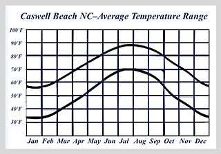
Summers in Caswell Beach are hot and humid with an average temperature of 85˚, although the beach front is cooled much of the time by sea breezes (the prevailing winds are from the southwest). Winters are moderate with an average temperature in the 50's, albeit with brief cold periods. Rain occurs throughout the year with average annual rainfall approximately 57", 45% of this falling between June and September.[11]
Tropical storms are a continuing source of concern,[12] e.g., in Oct. 1954 Hurricane Hazel washed away almost all the houses on Oak Island. A threat in late summer/early fall, the 1996-1999 period was intense with four major hurricanes (Bertha, Fran, Bonnie, and Floyd} making landfall and having significant effects on the area, while in the fall of 2005, Hurricane Ophelia and Tropical Storm Tammy combined to cause flooding in low-lying areas.[13] More recently, in October 2016, the eye of Hurricane Matthew passed almost directly over the town inflicting extensive damage to the dune system, and in September 2108, Hurricane Florence caused severe flooding and wind damage in addition to washing away most of the beach sand added earlier in the year
| Historical population | |||
|---|---|---|---|
| Census | Pop. | %± | |
| 1980 | 110 | — | |
| 1990 | 175 | 59.1% | |
| 2000 | 370 | 111.4% | |
| 2010 | 398 | 7.6% | |
| Est. 2016 | 429 | [1] | 7.8% |
| U.S. Decennial Census[14] | |||
Demographics
The 398 people identified in the 2010 census reside in 187 permanent households (overall there were 685 housing units in Caswell Beach at the time of the census). This population is essentially all white, fairly elderly (median age 63) with more women (215) than men (183). Median household income is $74,219. None of the population or families were below the poverty line. While the number of full-time residents is fairly small, in the summer peak population reaches 2000, mostly family vacationers using rental properties.[2]
Housing
Large single family homes, many of which serve as vacation rental properties, can be found along the beach strand at the east end of town, while on the west end, the ocean-front Oak Island Beach Villas feature condo rental units. Most of the full-time residents live clustered in and around the golf course in various types of housing: the Arboretum[15] (single family homes), Caswell Dunes[16] (patio homes and condo units), and Ocean Greens (single family, duplexes, townhouses, and luxury condos).
Government
The town government operates under a mayor-council-administrator type system where various officials have authority to make decisions on services, revenues and expenditures in accordance with a state issued charter. The Governing Body consists of six members (the Mayor who votes only in case of a tie and five Commissioners) all of whom are elected for four year terms on a two-year rotational schedule. Town Hall is located in the west end of town next to the newly constructed Public Services Facility, which houses the Caswell Beach Police and Public Works Departments along with units of the Southport Fire Department and Brunswick County EMS. [17]
Attractions
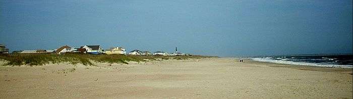
Beach. In way of combating erosion rates ranging from 2-5’ per year, the town’s three mile long, south facing beach has been re-nourished three times in the past 17 years as part of the Wilmington Harbor Channel dredging project[18] The beach also serves as a sea turtle nesting area,[19] which has spurred a vigorous dune protection and restoration program featuring sea oats/beach grass plantings.[20] This program not only benefits turtle nesting but protects the town against hurricane storm surge damage. As for public access to the beach, the town maintains a free parking lot and 12 walkways spread out along the strand, most of which have wheelchair ramps.


Golf Course. The 18 hole, par 72 course at the Oak Island Golf Club is open to the public. The 6,720 yard course layout has 37 bunkers and water in play on 11 different holes with five sets of tees (back tees are course rated at 73.1 with a slope of 139). The course features ultradwarf TifEagle greens[21] and Bermuda tees/fairways/rough while Long Leaf Pines, Live Oaks and Yaupon Holly trees border most every fairway. George Cobb, co-designer of Augusta National's par 3 course, is the architect. A full practice facility is available to the public which includes a putting green, sand traps and a driving range.[22]
Lighthouse. The Oak Island Lighthouse grounds are open to the public year-round for viewing and picture taking, with limited 30 minute parking provided at the base of the tower from sunrise until sunset. During the summer months, two types of interior tours are available (the one to the top is by appointment only). The light is maintained by personnel housed at the adjacent Coast Guard Station, while the structure itself is cared for and managed by a citizens group, Friends of Oak Island Lighthouse (FOIL). A major exterior rehabilitation project was completed in 2016, notable in that it was funded entirely by contributions.[23]
Fort Caswell. Fort Caswell is accessible by the public to a limited extent per the conditions set forth by the Director, North Carolina Baptist Assembly.[24] Now utilized as a Christian retreat and conference center, during the Civil War it defended Confederate positions on the North Carolina coast. Subsequently, it served as an army training ground in World War I and as a patrol communications base in World War II. Thus its forts and batteries provide opportunities to view and connect with a significant part of US history.[25] Also a part of the Fort Caswell Historic District but located further west in the Caswell Dunes area are rifle pits used by WW I soldiers for target practice.[26]
Natural Attractions. Given its small population and remote location, much of the town’s charm rests with its salt and fresh water marshes and a maritime forest, all of which support a wide range of plant and animal life. Alligators, turtles, foxes, deer, raccoons, beavers, eagles, brown pelicans, great white and blue herons, and ibis abound, while an occasional bear has been known to swim across the Intracoastal Waterway to visit the town. As for plant diversity, live oak, Longleaf Pine and Yaupon Holly predominate in the forest, while Azaleas, American Beautyberry and Sweet Bay Magnolia thrive both in natural and landscaped areas.[27]
Oak Island. The Town of Oak Island, which occupies the rest of the island, has a contract post office, a branch of the county library, a Food Lion, an ABC Liquor Store, two fishing piers (one of which is closed awaiting reconstruction)[28] a few gas stations, numerous small professional offices/retail stores, and a large number of restaurants.[29]
Southport. Located just across the ICW is the city of Southport (pop. 3,700). Founded as Smithville in 1792, it is home to the NC Fourth of July Festival and has been the location for many movies, one of the more notable being Safe Haven (2013). The part of town known as “Old Southport” has many historic houses and buildings, e.g. Fort Johnston, and situated on its waterfront is the North Carolina Maritime Museum at Southport and year-round ferry service that provides scenic trips across the Cape Fear River [30] to the NC Aquarium and Civil War battleground site at Fort Fisher.[31]
References
- 1 2 "Population and Housing Unit Estimates". Retrieved June 9, 2017.
- 1 2 "American FactFinder". United States Census Bureau. Archived from the original on 2013-09-11. Retrieved 2016-05-22.
- ↑ "US Board on Geographic Names". United States Geological Survey. 2007-10-25. Retrieved 2008-01-31.
- 1 2 "Geographic Identifiers: 2010 Demographic Profile Data (G001): Caswell Beach town, North Carolina". U.S. Census Bureau, American Factfinder. Retrieved February 11, 2014.
- ↑ http://www.hpo.ncdcr.gov/nr/BW0260.pdf
- ↑ "Caswell Beach". Star-News. May 24, 1998. p. 32. Retrieved 1 November 2015.
- ↑ Proffitt, Martie (Apr 17, 1983). "Local history offers tasty tidbits". Star-News. pp. 1C. Retrieved 1 November 2015.
- ↑ "National Register of Historic Places Listings". Weekly List of Actions Taken on Properties: 12/30/13 through 1/03/14. National Park Service. 2014-01-10.
- ↑ Bausch F. A. (2013). Nothing Like Losing. Caswell Beach , NC: Amazon. ISBN 978-0-9853517-6-2.
- ↑ "US Gazetteer files: 2010, 2000, and 1990". United States Census Bureau. 2011-02-12. Retrieved 2011-04-23.
- ↑ NowData - NOAA Online Weather Data, National Oceanic and Atmospheric Administration. Accessed May 21, 2016.
- ↑ "NHC Hurricane Summary". NHC.NOAA.com. Retrieved 2018-10-14.
- ↑ Barnes, Jay (2013). North Carolina's Hurricane History: Forth Edition. Boone, North Carolina: UNC Press Books.
- ↑ "Census of Population and Housing". Census.gov. Archived from the original on April 22, 2013. Retrieved June 15, 2016.
- ↑ http://www.arboretumhoa.org
- ↑ http://www.caswellduneshoa.com
- ↑ http://www.brunswickcountync.gov/emergency/ems/
- ↑ http://www.saw.usace.army.mil/Portals/59/docs/navigation/Dredging/Projects/Appendix%20H%20EA%20SMP%20(2000)%20June%202014.pdf
- ↑ http://caswellturtlewatch.org
- ↑ Rogers, Spencer; Nash, David (2003). The Dune Book. North Carolina Sea Grant. ISBN 9780974780115
- ↑ http://gsrpdf.lib.msu.edu/ticpdf.py?file=/article/lowe-lessons-1-11-13.pdf
- ↑ http://www.oakislandgolf.com
- ↑ http://www.oakislandlighthouse.org
- ↑ http://www.fortcaswell.com/about
- ↑ Herring, Ethel; Williams, Carolee (1999). Fort Caswell in War and Peace. Oak Island, NC: NC Baptist Assembly. ISBN 978-0967189710.
- ↑ http://www.caswellriflerange.com
- ↑ https://projects.ncsu.edu/cals/plantbiology/ncsc/Coastal_Planting_Guide.pdf
- ↑ http://www.oakislandpier.com
- ↑ http://www.oakislandnc.com
- ↑ https://www.ncdot.gov/download/transit/ferry/ferryschedule.pdf
- ↑ http://www.cityofsouthport.com
External links
![]()
| Preceded by Fort Caswell |
Beaches of Southeastern North Carolina | Succeeded by Oak Island |
Municipalities and communities of Brunswick County, North Carolina, United States | ||
|---|---|---|
| Cities | 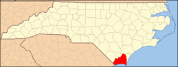 | |
| Towns | ||
| Village | ||
| Townships |
| |
| Unincorporated communities | ||