Half Hell, North Carolina
| Half Hell | |
|---|---|
| Unincorporated community | |
 Half Hell Location in North Carolina  Half Hell Half Hell (the US) | |
| Coordinates: 34°2′26″N 78°9′19″W / 34.04056°N 78.15528°WCoordinates: 34°2′26″N 78°9′19″W / 34.04056°N 78.15528°W | |
| Country | United States |
| State | North Carolina |
| County | Brunswick |
| Elevation | 30 ft (9 m) |
| Time zone | UTC-5 (Eastern (EST)) |
| • Summer (DST) | UTC-4 (EDT) |
| GNIS feature ID | 1020587[1] |
Half Hell is an unincorporated community in Brunswick County, North Carolina, United States.[1]
The settlement is located on Highway 906, approximately 2 mi (3.2 km) south of Bolivia. "Half Hell Swamp" is located approximately 2 mi (3.2 km) south of Half Hell.[2]
History
The settlement's name may have originated in the 1800s when settlers migrating south encountered dense swamps located there. Unable to cross, they settled at that location "halfway to hell". The name "Half Hell" may have also originated from the area's early reputation for illegal activities, particularly moonshining. Finally, the name may have been a reference to the midway point—"half way to hell"—for local farmers traveling to Southport to pay their taxes.[3][4]
Greenlands Farm is located in Half Hell. The Half Hell Folk Festival is held there annually.[4]
References
- 1 2 U.S. Geological Survey Geographic Names Information System: Half Hell
- ↑ U.S. Geological Survey Geographic Names Information System: Half Hell Swamp
- ↑ Holland, Makenzie (October 30, 2016). "What's the Story Behind Brunswick County's Half Hell Swamp?". Star News.
- 1 2 Schachtman, Benjamin (February 15, 2017). "Heaven at Half Hell: Greenlands Farm Reopens Store and Reinvigorates Family Farming". Port City Dail.
Municipalities and communities of Brunswick County, North Carolina, United States | ||
|---|---|---|
| Cities | 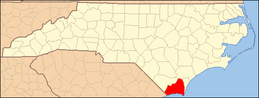 | |
| Towns | ||
| Village | ||
| Townships |
| |
| Unincorporated communities | ||