Oak Island (North Carolina)
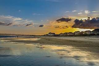 Oak Island beach at sunset | |
 Oak Island | |
| Geography | |
|---|---|
| Location | Atlantic Ocean |
| Coordinates | 33°54′37″N 78°03′38″W / 33.91028°N 78.06056°W |
| Length | 12 mi (19 km) |
| Administration | |
|
USA | |
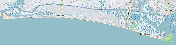
Oak Island is located on the Atlantic Ocean coast in Brunswick County, North Carolina near the South Carolina border. A barrier island, it contains the towns of Oak Island and Caswell Beach, Fort Caswell (since 1949 home to the North Carolina Baptist Assembly), a United States Coast Guard station co-located with the Oak Island Lighthouse and the Oak Island Golf Club. Almost 13 miles long, the island averages about one mile wide. Approximately 7000 people live on it year-round, a number which can balloon to over 40,000 during the summer[1]
Geography
Roughly 30 miles south of Wilmington, North Carolina, Oak Island is the easternmost of the South Brunswick Islands formed in the late 1930s by the construction of the Intracoastal Waterway (ICW). Dredged from Southport, NC at the mouth of the Cape Fear River, the ICW flows south through coastal sounds and marshes to the Little River in South Carolina. Both ends of Oak Island have extensive marshland, while its two major internal waterways (Davis Canal and Montgomery Slough) run east to west and drain into the Lockwood Folly River. Elevations range from sea level to a 50' high knoll on the west end of the island.[2]
History
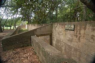
While Native Americans most likely used the island for fishing, the first permanent settlement took place in the 1830s on the island's east end at Fort Caswell.[3] Now utilized as a Christian retreat and conference center, during the Civil War the fort defended Confederate positions on the North Carolina coast and subsequently served as an army training ground in World War I and a patrol/ communications base in World War II.[4] In 2013, along with Rifle Pits constructed during WWI [5] in Caswell Beach, it was designated as a National Historic District.[6]
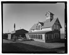
In the early 1800s, in recognition of the dangers to navigation caused by Frying Pan Shoals, Jay Bird Shoals, and Bald Head Shoals,[7] which lay south and southeast of the island, construction of a series of lighthouses and life saving stations in the area began. Starting with Old Baldy on Bald Head Island, this construction eventually included the 1889 Oak Island Life Saving Station located 1/2 mile west of Fort Caswell.[8] Still standing today, it features a large lookout tower projecting from its roof. In 1938 it was sold to a private owner and moved directly across the road from its original location near where the current lighthouse stands.[9]
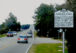
By the 1930s the island had blossomed into a vacation resort, as beach cottages began to dot the area on its western half, something which Hurricane Hazel brought a temporary halt to in 1954 as it washed away some 350 buildings on or near the ocean front.[10] One of the greatest natural disasters to ever affect the state, Hazel was also one of the most destructive hurricanes to strike the United States.[11] The island quickly recovered and development continued anew with the towns of Long Beach and Yaupon Beach being incorporated in 1955; in 1999 they were jointly incorporated into the Town of Oak Island.[12]
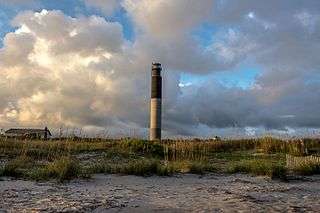
In 1958, the Oak Island Lighthouse became operational. Located on the east end of the island, in 2004 the Town of Caswell Beach acquired it and in 2007 it was added to the National Register of Historic Places. [13] In 1962 the first 9 holes of the Oak Island Golf Club designed by George Cobb opened for play. The second nine holes was completed in 1975, the same year the Town of Caswell Beach was incorporated. As a result of both the course and island's sequential development, 13 holes of the golf course are in Caswell Beach while 5 are in the Town of Oak Island.
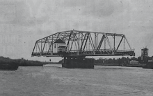
Along with this increasing level of development came strident demands for reliable access to and from the island. When the ICW was completed, a swingbridge initially provided this service. Destroyed by a barge strike in 1971, construction of a high rise replacement (Barbee Bridge) began almost immediately; it opened for traffic in 1975 (interim service included a ferry and pontoon bridge).[14] Due to safety concerns, the bridge will be closed for repairs beginning in October 2018 for six months.[15] A second high rise structure (Swain's Cut Bridge) crossing was completed in 2010.[16]
Climate
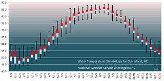
Summers on Oak Island are hot and humid with an average temperature of 85˚, although the beach front is cooled much of the time by sea breezes (the prevailing winds are from the southwest). Ocean water temperatures range from the 50s to the mid 80s. Winters are moderate with an average temperature in the 50's, albeit with brief cold periods. Rain occurs throughout the year with average annual rainfall approximately 57", 45% of this falling between June and September.[17] Tropical storms are a continuing source of concern, e.g., in the 1996-1999 period, four major hurricanes (Bertha, Fran, Bonnie, and Floyd) made landfall and had significant effects on the area,[18] while in October 2016, the eye of Hurricane Matthew passed almost directly over the island causing flooding and extensive damage to parts of the dune system.[19]

Recreation/Activities
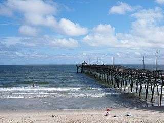
Primarily a family beach type locale, the island also provides many other types of recreational activity. The Oak Island Golf Club course and its related practice facilities are open to the public and an outdoor swimming pool is available for its members' use during the summer.[20] Two public fishing piers jut out into the Atlantic Ocean (one is currently being reconstructed)[21][22] while motor/sail boats moored to piers dot the ICW as well as the Davis Canal and Montgomery Slough. All these waterways also attract a large number of kayakers.
The Oak Island Recreation Center located mid-island provides both indoor and outdoor exercise facilities and rents out sports equipment and amenities like balloon tire, beach wheelchairs.[23] Popular sporting events include the "Run Oak Island" Marathon held in February which also features a half-marathon along with a 5K and one mile run.[24] And then in April, the Southport/Oak Island Chamber of Commerce sponsors the Oak Island Lighthouse Run which includes a half marathon, 10K, 5K and a one mile fun run.[25]
As for other activities, the Town of Oak Island puts on an ocean front fireworks display as part of its Fourth of July festivities, and a parade down Oak Island Drive just before Christmas. Tours of the Oak Island Lighthouse can be scheduled year round, with trips to the top available by appointment given two weeks advance notice (four weeks in the summer months).[26] Monthly Civil War Roundtables are held at the Hatch Auditorium in the NC Baptist Assembly[27] while the Oak Island Library hosts a wide variety of events to include "Socrates Cafe" and "Meet the Author" programs.[28]
References
- ↑ "What Are Some Facts About Oak Island, North Carolina?".
- ↑ "Oak Island Topo Map, Brunswick County NC (Southport Area)".
- ↑ "About Us". 9 June 2015.
- ↑ Herring, Ethel; Williams, Carolee (1999). Fort Caswell in War and Peace. Oak Island, NC: NC Baptist Assembly. ISBN 978-0967189710.
- ↑ "Friends of Fort Caswell Rifle Range, Inc". Friends of Fort Caswell Rifle Range, Inc.
- ↑ "National Register of Historic Places Listings". Weekly List of Actions Taken on Properties: 12/30/13 through 1/03/14. National Park Service. 2014-01-10.
- ↑ "Love Your Island: What's In A Shoal?".
- ↑ http://www.hpo.ncdcr.gov/nr/BW0260.pdf
- ↑ M. Ruth Little (August 2000). "Oak Island Life Saving Station" (pdf). National Register of Historic Places - Nomination and Inventory. North Carolina State Historic Preservation Office.
- ↑ WRAL. "Documentary: Hurricane Hazel :: WRAL.com". WRAL.com.
- ↑ "Hurricane Hazel". www4.ncsu.edu.
- ↑ http://www.ncleg.net/EnactedLegislation/SessionLaws/PDF/1999-2000/SL1999-66.pdf
- ↑ "National Register of Historic Places" (PDF). NC Register of Historic Places.gov. Retrieved 2018-09-06.
- ↑ Furstenau, Wolfgang (1995). Long Beach. Long Beach, NC: Furstenau. ISBN 978-09648233-0-3.
- ↑ "Oak Island bridge closure reduced to six months; towns, agencies meet to discuss impact".
- ↑ "Long-awaited Oak Island bridge opens for traffic".
- ↑ [http://www.nws.noaa.gov/climate/xmacis.php?wfo=phi NowData - NOAA Online Weather Data National Oceanic and Atmospheric Administration. Accessed February, 2017.
- ↑ Barnes, Jay (2013). North Carolina's Hurricane History: Forth Edition. Boone, North Carolina: UNC Press Books.
- ↑ "Storm Causes Damage in the Millions". State Port Pilot. November 2, 2016.
- ↑ "Oak Island Golf Club - Welcome to Oak Island Golf". www.oakislandgolf.com.
- ↑ "Ocean Crest Pier Oak Island NC Fishing". www.oceancrestpiernc.com.
- ↑ "Welcome". www.oakislandpier.com.
- ↑ RecDesk. "Oak Island Recreation Center". Oak Island Parks & Recreation - POWERED BY RECDESK.
- ↑ https://runsignup.com/Race/NC/OakIsland/RunOakIsland
- ↑ https://www.oakislandlighthouserun.com/race-info/1-2-marathon-race/ https://coastalraceproductions.com/race/run-oak-island/
- ↑ "Oak Island Lighthouse". www.oakislandlighthouse.org.
- ↑ "About Us - Brunswick Civil War Round Table". brunswickcivilwarroundtable.com.
- ↑ http://www.brunswickcountync.gov/venue/barbee-library/