Araripe Basin
| Araripe Basin | |
|---|---|
| Bacia do Araripe | |
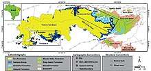 Geologic map of the Araripe Basin | |
 | |
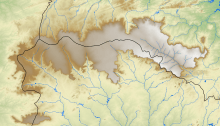 Outline of the Chapada do Araripe in the basin | |
| Coordinates | 7°23′12″S 40°9′11″W / 7.38667°S 40.15306°WCoordinates: 7°23′12″S 40°9′11″W / 7.38667°S 40.15306°W |
| Etymology | Chapada do Araripe |
| Location | South America |
| Region | Northeast |
| Country |
|
| State(s) | Ceará, Pernambuco, Piauí |
| Cities | Crato, Ceará |
| Characteristics | |
| On/Offshore | Onshore |
| Boundaries | Patos & Pernambuco lineaments |
| Part of | Brazilian onshore basins |
| Area | ~8,000 km2 (3,100 sq mi) |
| Geology | |
| Basin type | Rift basin |
| Plate | South American |
| Orogeny | Break-up of Gondwana |
| Age | Middle Jurassic-Albian |
| Stratigraphy | Stratigraphy |
The Araripe Basin (Portuguese: Bacia do Araripe) is a rift basin covering about 8,000 square kilometres (3,100 sq mi),[1] in Ceará, Piauí and Pernambuco states of northeastern Brazil. It is bounded by the Patos and Pernambuco lineaments,[2] and is situated east of the Parnaíba Basin, southwest of the Rio do Peixe Basin and northwest of the Tucano and Jatobá Basins.[3]
The basin has provided a variety of unique fossils in the Crato and Santana Formations and includes the Araripe Geopark, a member of the UNESCO Global Geoparks since 2006.[4] The pterosaurs Araripesaurus and Araripedactylus (now considered a nomen dubium), crocodylian Araripesuchus, the turtle Araripemys, amphibian Arariphrynus, the fish Araripelepidotes and the insect Araripenymphes were named after the basin. The bituminous shales of the Ipubi Formation in the Araripe Basin have potential for shale gas development.[5]
Stratigraphy

| Age | Group | Formation | Sequence | Notes |
|---|---|---|---|---|
| Cenozoic | Alluvium | |||
| Albian | Araripe Group | Exu Formation | Post-rift | [6][7] |
| Arajara Formation | ||||
| Araripina Formation | [8] | |||
| Albian Aptian | Santana Group | Romualdo Formation | [7] | |
| Ipubi Formation | [7][9] | |||
| Crato Formation | [6][7] | |||
| Araripe Group | Barbalha Fm./Rio da Batateira Fm. | [6][7][8] | ||
| Early Cretaceous | Vale do Carirí Group | Abaiara Formation | Pre- and syn-rift | [7][8] |
| Missão Velha Formation | [6][7][8] | |||
| Late Jurassic | ||||
| Brejo Santo Formation | ||||
| Middle Jurassic | ||||
| Early Jurassic | unconformity | |||
| Triassic | ||||
| Permian | ||||
| Carboniferous | ||||
| Devonian | Paleozoic sequence | Mauriti Formation Mucuri Formation | Pre-rift | |
| Silurian | ||||
| Ordovician | unconformity | |||
| Cambrian | ||||
| Precambrian | Basement | |||
Basin history
The tectono-sedimentary evolution of the Araripe Basin, located in the Borborema Geologic Province, encompasses four stages, with five tectonostratigraphic phases:[10]
1) Syneclise phase - Silurian to Devonian - characterized by tectonic quiescence in the Borborema Province. It is represented by the deposits of the Cariri Formation, that include medium to coarse-grained quartz sandstones, locally conglomeratic, deposited in large braided fluvial systems
2) Pre-rift phase - Tithonian - characterized by the mechanical subsidence due to lithosphere thinning that preceded the rift. It is represented by the Brejo Santo Formation, that comprises red shales and claystones, and the Missão Velha Formation, constituted by medium to coarse-grained quartz-feldspathic sandstones, locally conglomeratic, that contains entire trunks and fragments of silicified wood (Dadoxilon benderi) conifer
3) Rift phase - Berriasian to Hauterivian - characterized by increasing mechanical subsidence that created a system of grabens and half grabens. It is represented by the Abaiara Formation, that includes shales, siltstones, sandstones and conglomerates
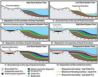
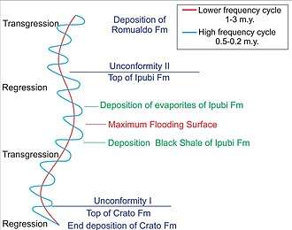
4) Post-Rift I phase - Aptian to Albian - characterized by thermal subsidence. The lowermost unit Barbalha Formation, represents a fluviolacustrine phase and is composed of red and gray shales, siltstones and claystones.
The Santana Group was formed during this stage and comprises three stratigraphic units:
- Crato Formation that is composed of six intervals of laminated limestones (C1 to C6), interbedded with calciferous siltstones and marls, and is very rich in fossils of vertebrate and invertebrate organisms
- Ipubi Formation, that is mainly composed of organic-rich, black greenish bituminous shales, claystones and algal limestones that are interbedded with gypsum-anhydrite beds
- Romualdo Formation, that represents a calciferous siliciclastic succession composed of fine to medium-grained sandstones, argillaceous siltstones, calciferous shales, and limestones, very rich in fossils. This formation recorded the marine proto-Atlantic incursion that involved the Araripe Basin, and other interior basins and created a large seaway throughout the Borborema Province during the Albian
5) Post-rift II phase - Albian to Cenomanian - characterized by a major sag phase, and is formed by two stratigraphic units:
- Araripina Formation, that occurs in the western region of the basin and is composed by rhythmites and heterolithic layers of reddish, purplish and yellowish fine-grained sandstone and mudstone
- Exu Formation, that comprises medium-to coarse grained sandstones, fine grained clayey sandstones and local conglomeratic beds
See also
References
- ↑ Neto et al., 2013, p.1
- ↑ Bianca Carvalho Vieira; André Salgado; Leonardo Santos. Landscapes and Landforms of Brazil. p. 232.
- ↑ Assine, 1992, p.290
- ↑ (in Portuguese) Chapada do Araripe vira parque geológico
- ↑ Neto et al., 2013, p.3
- 1 2 3 4 Bétard et al., 2017, p.10
- 1 2 3 4 5 6 7 Assine, 1992, p.291
- 1 2 3 4 Scherer et al., 2013, p.28
- ↑ Ribeiro et al., 2011, p.62
- ↑ Fabin et al., 2018, pp.2051-2052
Bibliography
- Assine, Mario L. 1992. Análise estratigráfica da Bacia do Araripe, Nordeste do Brasil. Revista Brasileira de Geociências 22. 289–300. Accessed 2018-08-21.
- Bétard, François; Jean-Pierre Peulvast; Alexsandra de Oliveira Magalhães; Maria de Lourdes Carvalho Neta, and Francisco Idalecio de Freitas. 2017. Araripe Basin: A Major Geodiversity Hotspot in Brazil. Geoheritage _. 1–18. Accessed 2018-08-21.
- Fabin, Carlos E.; Osvaldo J. Correia Filho; Márcio L. Alencar; José A. Barbosa; Tiago S. de Miranda; Virgínio H. Neumann; Igor F. Gomes, and Felipe R. de Santana. 2018. Stratigraphic Relations of the Ipubi Formation: Siliciclastic-Evaporitic Succession of the Araripe Basin. Anais da Academia Brasileira de Ciências 90. 2049–2071. Accessed 2018-10-05.
- Neto, João Adauto; Haydon Mort; Ricardo Pereira; José Barbosa; Virginio Neumann; Walter Vortisch; Osvaldo J. C. Filho; Paulo de A. L. S. Brandão, and José G. A. Pacheco. 2013. Carbonaceous Shales in the Araripe Basin, NE Brazil: A Potential Shale Gas Reservoir, 1–7. AAPG Annual Convention and Exhibition. Accessed 2018-08-21.
- Ribeiro Oliveira, Gustavo; Antônio Álamo Feitosa Saraiva; Helder de Paula Silva; José Artur Ferreira Gomes de Andrade, and Alexander Wilhelm Armin Kellner. 2011. First turtle from the Ipubi Formation (Early Cretaceous), Santana Group, Araripe Basin, Brazil. Revista Brasileira da Paleontologia 14. 61–66. Accessed 2018-08-21.
- Scherer, C.M.d.S.; E.F. Jardim de Sá; V.C. Córdoba; D.d.C. Sousa; M.M. Aquino, and F.M.C. Cardoso. 2013. Tectono-Stratigraphic evolution of the upper Jurassic-Neocomian rift succession, Araripe Basin, Northeast Brazil. Journal of South American Geosciences _. 1–43. Accessed 2018-08-21.
Further reading
- Aparecida dos Reis Polck, Márcia; Marise Sardenberg Salgado de Carvalho; Raphael Miguel, and Valéria Gallo. 2015. Guia de identificação de peixes fósseis das Formações Crato e Santana da Bacia do Araripe, 1-74. Serviço Geológico do Brasil (CPRM).
- Báez, A.M.; G.J.B. Moura, and R.O. Gómez. 2009. Anurans from the Lower Cretaceous Crato Formation of northeastern Brazil: implications for the early divergence of neobatrachians. Cretaceous Research 30. 829–846. Accessed 2018-10-06.
- Bechly, G., and V. N. Makarkin. 2016. A new gigantic lacewing species (Insecta: Neuroptera) from the Lower Cretaceous of Brazil confirms the occurrence of Kalligrammatidae in the Americas. Cretaceous Research 58. 135–140. Accessed 2018-10-06.
- Cavalcanti Duque, Rudah Ruano, and Alcina Magnólia Franca Barreto. 2018. Novos Sítios Fossilíferos da Formação Romualdo, Cretáceo Inferior, Bacia do Araripe, Exu, Pernambuco, Nordeste do Brasil - New Fossiliferous Sites of the Romualdo Formation, Lower Cretaceous, Araripe Basin, Exu, Pernambuco, Northeast of Brazil. Anuário do Instituto de Geociências, UFRJ 41. 5–14. Accessed 2018-10-06.
- Elgin, Ross A., and Eberhard Frey. 2011. A new ornithocheirid, Barbosania gracilirostris gen. et sp. nov. (Pterosauria, Pterodactyloidea) from the Santana Formation (Cretaceous) of NE Brazil. Swiss Journal of Palaeontology 130. 259. Accessed 2018-10-06.
- Fara, Emmanuel; Antônio Á.F. Saraiva; Díogenes de Almeida Campos; João K.R. Moreira; Daniele de Carvalho Siebra, and Alexander W.A. Kellner. 2005. Controlled excavations in the Romualdo Member of the Santana Formation (Early Cretaceous, Araripe Basin, northeastern Brazil): stratigraphic, palaeoenvironmental and palaeoecological implications. Palaeogeography, Palaeoclimatology, Palaeoecology 218. 145–160. Accessed 2018-10-06.
- Figueiredo, R.G., and A.W.A. Kellner. 2009. A new crocodylomorph specimen from the Araripe Basin (Crato Member, Santana Formation), northeastern Brazil. Paläontologische Zeitschrift 83. 323–331. Accessed 2018-10-06.
- Jorge de Lima, Flaviana; Antonio Álamo Feitosa Saraiva, and Juliana Manso Sayão. 2012. Revisão da paleoflora das Formações Missão Velha, Crato e Romualdo, Bacia do Araripe, nordeste do Brasil. Estudos Geológicos 22. 99–115.
- Leite da Silva, Agnelo, and Virginio Enrique Neumann. 2003. Formação Crato da Bacia do Araripe: um reservatório análogo ao Calcário Trairí (Formação Paracuru), Bacia do Ceará, 1–6. 2o Congresso Brasileiro de P&D em Petróleo & Gás. Accessed 2018-10-06.
- Maisey, J.G.; I. Rutzky; S. Blum, and W. Elvers. 1991. Laboratory Preparation Techniques. In Maisey, j:G. (ed): Santana Fossils: An Illustrated Atlas, 99–103. Tfh Publications Inc.. ISBN 0866225498
- Makarkin, V.N., and F. Menon. 2007. First record of fossil 'rapismatid-like' Ithonidae (Insecta, Neuroptera) from the Lower Cretaceous Crato Formation of Brazil. Cretaceous Research 28. 743–753. Accessed 2018-10-06.
- Martill, David M.; Günter Bechly, and Robert F. Loveridge. 2007. The Crato Fossil Beds of Brazil: Window into an Ancient World, 236. Cambridge University Press. Accessed 2018-10-06. ISBN 978-1-139-46776-6
- Martill, D.M. 2007. The age of the Cretaceous Santana Formation fossil Konservat Lagerstätte of north-east Brazil: a historical review and an appraisal of the biochronostratigraphic utility of its palaeobiota. Cretaceous Research 28. 895–920. Accessed 2018-10-06.
- Myskowiak, J.; D. Huang; D. Azar; C. Cai; R. Garrouste, and A. Nel. 2016. New lacewings (Insecta, Neuroptera, Osmylidae, Nymphidae) from the Lower Cretaceous Burmese amber and Crato Formation in Brazil. Cretaceous Research 59. 214–227. Accessed 2018-10-06.
- Neumann, V.H.; A.G. Borrego; L. Cabrera, and R. Dino. 2003. Organic matter composition and distribution through the Aptian–Albian lacustrine sequences of the Araripe Basin, northeastern Brazil. International Journal of Coal Geology 54. 21–40. Accessed 2018-10-05.
- Pinheiro, Allysson P.; Antônio Á.F. Saraiva, and William Santana. 2014. Shrimps from the Santana Group (Cretaceous: Albian): new species (Crustacea: Decapoda: Dendrobranchiata) and new record (Crustacea: Decapoda: Caridea). Anais da Academia Brasileira de Ciências _. 1–8. Accessed 2018-10-06.
- Prado, Gustavo M.E.M.; Guilherme Raffaelli Romero, and Luiz Eduardo Anelli. 2016. New occurrences of fossilized feathers: systematics, taphonomy, and paleoecology of the Santana Formation of the Araripe Basin (Cretaceous), NE, Brazil. PeerJ _. 1–49. Accessed 2018-10-06.
- Salisbury, S.W.; E. Frey; D.M. Martill, and M.C. Buchy. 2003. A new crocodilian from the Lower Cretaceous Crato Formation of north-eastern Brazil. Palaeontographica. Abteilung A, Palaozoologie - Stratigraphie 270. 3–47. Accessed 2018-10-06.
- Scherer, C.M.d.S.; E.F. Jardim de Sá; V.C. Córdoba; D.d.C. Sousa; M.M. Aquino, and F.M.C. Cardoso. 2013. Tectono-Stratigraphic evolution of the upper Jurassic-Neocomian rift succession, Araripe Basin, Northeast Brazil. Journal of South American Geosciences _. 1–43. Accessed 2018-10-05.
- Weishampel, David B. et al. 2004. Dinosaur distribution (Early Cretaceous, South America) in: Weishampel, David B.; Dodson, Peter; and Osmólska, Halszka (eds.): The Dinosauria, 563–570. Berkeley: University of California Press. ISBN 0-520-24209-2
Sedimentary basins of Brazil | ||||||||||
|---|---|---|---|---|---|---|---|---|---|---|
| Onshore |
| | ||||||||
| Offshore |
| |||||||||
| Source |
| |||||||||