Inselberg
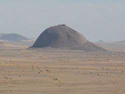
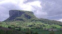
An inselberg or monadnock (/məˈnædnɒk/) is an isolated rock hill, knob, ridge, or small mountain that rises abruptly from a gently sloping or virtually level surrounding plain. In southern and south-central Africa, a similar formation of granite is known as a koppie, an Afrikaans word ("little head") from the Dutch word kopje.[1] If the inselberg is dome-shaped and formed from granite or gneiss, it can also be called a bornhardt, though not all bornhardts are inselbergs.
Etymology
Inselberg
The word inselberg is a loan word from the German word Inselberg, which has the literal meaning of "island mountain". The name was coined in 1900 by geologist Wilhelm Bornhardt (1864–1946) to describe the abundance of such features found in southern Africa.[2] At that time, the term applied only to arid landscape features. However, the term inselberg has since been used to describe a broader geography and range of rock features, leading to confusion about the precise definition of the term. In a 1973 study examining the use of the term, one researcher found that the term had been used for features in savannah climates 40% of the time, arid or semi-arid climates 32% of the time, humid-subtropical and arctic 12% of the time, and 6% each in humid-tropical and Mediterranean climates. As recently as 1972, the term has been defined as "steep-sided isolated hills rising relatively abruptly above gently sloping ground". This definition includes such features as buttes; conical hills with rectilinear sides typically found in arid regions; regolith-covered concave-convex hills; rock crests over regolith slopes; rock domes with near vertical sides; tors (koppies) formed of large boulders but with solid rock cores. Thus, the terms monadnock and inselberg may not perfectly match,[3] though some authors have explicitly argued these terms are in fact completely synonymous.[4]

Monadnock

Monadnock is an originally Native American term for an isolated hill or a lone mountain that stands above the surrounding area, typically by surviving erosion. Geologists took the name from Mount Monadnock in southwestern New Hampshire.[5] It is thought to derive from the Abenaki language, from either menonadenak (smooth mountain) or menadena (isolated mountain).[6] In this context, monadnock is used to describe a mountain that rises from an area of relatively flat and/or lower terrain. For instance, Mount Monadnock rises 2,000 feet (610 m) above its surrounding terrain and stands, at 3,165 feet (965 m), nearly 1,000 feet (300 m) higher than any mountain peak within 30 miles (48 km).[7]
Geology
Volcanic or other processes may give rise to a body of rock resistant to erosion, inside a body of softer rock such as limestone, which is more susceptible to erosion. When the less resistant rock is eroded away to form a plain, the more resistant rock is left behind as an isolated mountain. The strength of the uneroded rock is often attributed to the tightness of its jointing.[8]
The presence of an inselberg typically indicates the existence of a nearby plateau or highland, or their remnants. This is especially the case for inselbergs composed of sedimentary rock, which will display the same stratigraphic units as this nearby plateau. However once exposed, the inselbergs are destroyed by marginal collapse of joint blocks and exfoliation sheets. This process leaves behind tors perched at their summits and, over time, a talus-bordered residual known as a castle koppie appears.[9][10] By this association various inselberg fields in Africa and South America are assumed to be the vestiges of eroded etchplains.[11][12]
Inselbergs can be reshaped by ice sheets much the same way as roche moutonnées. In northern Sweden, examples of this type of inselberg have been termed flyggbergs.[13]:326–327[14]
Examples
Uluru and Kata Tjuta in Australia are inselbergs.[15]
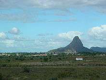
Clusters of inselbergs, called inselberg fields and inselberg plains, occur in various parts of the world. These areas include Tanzania,[16] the Anti-Atlas of Morocco,[11] Northeast Brazil,[17] Namibia,[18] the interior of Angola,[19] and the northern portions of Finland[20][21] and Sweden.[22][upper-alpha 1]
Ecology
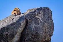
The koppies of Eastern Africa tend to be a refuge for life in the Serengeti of Tanzania and Kenya. Where the soil is too thin or hard to support tree life in large areas, soil trapped by koppies can be dense with trees while the surrounding land contains only short grass. Hollows in the rock surfaces provide catchments for rainwater.[24] Many animals have adapted to the use of koppies, including the lion, the hyrax, and an abundance of bird and reptile life.
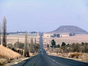 Houtkop (1,751 m), an outcrop of Drakensberg basalt in the Free State, South Africa
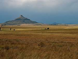 A conical sandstone koppie in the Free State, South Africa
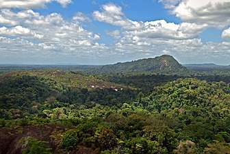 An inselberg in the rainforest of Suriname
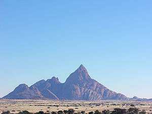 The granitic Spitzkoppe of Namibia, formed by early Cretaceous rifting and magmatism
See also
Notes
- ↑ Albeit its not the usual way of describing it the strandflat of Norway was held by Julius Büdel to be an etchplain with inselbergs.[23]
References
- ↑ Webster's New Explorer Dictionary of Word Origins (2004). Federal Street Press: New York.
- ↑ Holmes, Arthur (1978). Holmes Principles of Physical Geology Taylor & Francis: New York.
- ↑ Gerrard, John (1988). Rocks and Landforms Routledge: Florence, Kentucky.
- ↑ King, L.C., 1953, Canons of landscape evolution: Bulletin of the Geological Society of America, v. 64, no. 7, p. 721–752.
- ↑ Raymo, Chet and Raymo, Maureen E. (1989) Written in Stone: A Geologic History of the Northeastern United States. Globe Pequot, Chester, Connecticut.
- ↑ "Vermont Soils with Names of American Indian Origin Archived 2009-03-20 at the Wayback Machine." United States Department of Agriculture, Natural Resources Conservation Service. Retrieved January 6, 2008.
- ↑ Baldwin, Henry I. (1989). Monadnock Guide 4th edition. Concord, New Hampshire: Society for the Protection of New Hampshire Forests.
- ↑ "A Dictionary of Ecology" (2004). Encyclopedia.com. Retrieved November 28, 2009
- ↑ "Summary: Inselbergs/Hills/Knobs" Desert Processes Working Group; Knowledge Sciences, Inc. Retrieved January 6, 2008.
- ↑ Easterbrook, Don J. "Chapter Three: Weathering." Surface Processes and Landforms. 2nd ed. Upper Saddle River, NJ: Prentice Hall, 1999. 45. Print.
- 1 2 Guillocheau, François; Simon, Brendan; Baby, Guillaume; Bessin, Paul; Robin, Cécile; Dauteuil, Olivier (2017). "Planation surfaces as a record of mantle dynamics: The case example of Africa". Gondwana Research.
- ↑ García, Carolina; Hermelin, Michel (2016). "Inselbergs Near Medellín". In Hermelin, Michel. Landscapes and Landforms of Colombia. Springer. p. 219. ISBN 978-3-319-11800-0.
- ↑ Douglas Benn and David Evans, Glaciers & Glaciation, Arnold, London, 1st ed. 1998 ISBN 978-0-340-58431-6
- ↑ Lidmar-Bergström, Karna; Olvmo, Mats (2015). Plains, steps, hilly relief and valleys in northern Sweden – review, interpretations and implications for conclusions on Phanerozoic tectonics (PDF) (Report). Geological Survey of Sweden. p. 13. Retrieved June 29, 2016.
- ↑ Twidale, C. R.; Campbell, E. M. (2005). Australian Landforms. Rosenberg. p. 141. ISBN 1-877058-32-7.
- ↑ Sundborg, Å., & Rapp, A. (1986). Erosion and sedimentation by water: problems and prospects. Ambio, 215-225.
- ↑ Maia, Rúbson Pinheiro; Frêgo Bezerra, Francisco Hilário; Leite Nascimento, Marcos Antônio; Sampaio de Castro, Henrique; de Andrade Meireles, Antônio Jeovah; Rothis, Luis Martin (2015). "Geomorfologia do Campo de Inselbergues de Quixadá, nordeste do Brasil" [Geomorphology of inselbergs field of Quixadá, Northeast Brazil]. Revista Brasileira de Geomorfogia (in Portuguese). 16 (2). doi:10.20502/rbg.v16i2.651. Retrieved November 14, 2017.
- ↑ "PRODUCTION OF AN AGRO.ECOLOGICAL ZONES MAP OF NAMIBIA (first approximation)" (PDF). nbri.org.na.
- ↑ DEVELOPMENT OF A SOIL AND TERRAIN MAP/DATABASE FOR ANGOLA
- ↑ Kaitanen, Veijo (1985). "Problems concerning the origin of inselbergs in Finnish Lapland". Fennia. 163 (2): 359–364.
- ↑ Ebert, K.; Hall, A.; Hättestrand, C.; Alm, G. (2009). "Multi-phase development of a glaciated inselberg landscape". Geomorphology. 115 (1): 56–66.
- ↑ Rudberg, S. (1988). Gross morphology of Fennoskandia: six complementary ways of explanation. Geografiska Annaler. Series A. Physical Geography, 135-167.
- ↑ Olesen, Odleiv; Kierulf, Halfdan Pascal; Brönner, Marco; Dalsegg, Einar; Fredin, Ola; Solbakk, Terje (2013). "Deep weathering, neotectonics and strandflat formation in Nordland, northern Norway". Norwegian Journal of Geology. 93: 189–213.
- ↑ Serengeti National Park Visitor Center, Tanzania
External links
| Wikimedia Commons has media related to Inselbergs. |
