Quartzsite, Arizona
| Quartzsite | |
|---|---|
| Town | |
| Quartzsite, Arizona | |
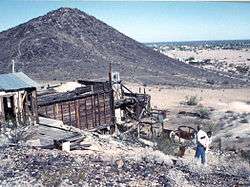 Abandoned mine near Quartzsite | |
| Motto(s): "The Rock Capital of the World" | |
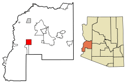 Location of Quartzsite in La Paz County, Arizona | |
| Coordinates: 33°39′50″N 114°13′48″W / 33.66389°N 114.23000°WCoordinates: 33°39′50″N 114°13′48″W / 33.66389°N 114.23000°W[1] | |
| Country | United States |
| State | Arizona |
| County | La Paz |
| Incorporated | 1989 |
| Government | |
| • Mayor | Ed Foster |
| Area[2] | |
| • Total | 36.30 sq mi (94.01 km2) |
| • Land | 36.30 sq mi (94.01 km2) |
| • Water | 0.00 sq mi (0.00 km2) |
| Elevation[1] | 879 ft (268 m) |
| Population (2010)[3] | |
| • Total | 3,677 |
| • Estimate (2016)[4] | 3,644 |
| • Density | 100.39/sq mi (38.76/km2) |
| Time zone | UTC-7 (MST (no DST)) |
| ZIP codes | 85346, 85359 |
| Area code(s) | 928 |
| FIPS code | 04-58010 |
| Website | Town of Quartzsite |
Quartzsite is a town in La Paz County, Arizona, United States. According to the 2010 census, the population was 3,677.[3]
Interstate 10 runs directly through Quartzsite which is at the intersection of U.S. Route 95 and Arizona State Route 95 with I-10.
History
Where Quartzite is now located, was from 1863 to the 1880s the site of a waterhole and later a stage station, called Tyson's Wells, along the La Paz - Wikenburg Road on Tyson Wash, in what was then Yuma County, in the newly created Arizona Territory. It was about 20 miles from the Colorado River steamboat landing of La Paz and 25 miles from the landing of Erhenburg from 1866. The next stop was 25 miles to the east at (Desert Station.[5]:xxvii [6] [7] [8]
Tyson's Wells in 1875, was described by Martha Summerhayes, in her book Vanished Arizona:
- "At all events, whatever Messrs. Hunt and Dudley were doing down there, their ranch (Desert Station) was clean and attractive, which was more than could be said of the place where we stopped the next night, a place called Tysons Wells. We slept in our tent that night, for of all places on the earth a poorly kept ranch in Arizona is the most melancholy and uninviting. It reeks of everything unclean, morally and physically."
- "One more day's travel across the desert brought us to our El Dorado (Ehrenberg)."[9]:144-145
In the valley around Tyson's Wells were placers that surrounded it, known to have been successfully worked by individual prospectors since the beginning of the Colorado Gold Rush of the 1860's up until the 1950's. Some large scale operations in the early 20th Century were failures.[10]
Geography and climate
According to the United States Census Bureau Quartzsite is all land and has a total area of 36.3 sq mi (94.0 km2).
Quartzsite lies on the western portion of the La Posa Plain along Tyson Wash. The Dome Rock Mountains overlook the town on the west with Granite Mountain on the southwest edge of the town and Oldman Mountain on the northwest. The Plomosa Mountains lie across the La Posa Plain to the east.[11]
The town has a hot desert climate (Köppen BWh) with mild to warm winters from November to March and hot to extreme summers for the remainder of the year. In the middle of summer, Quartzsite is one of the hottest places in the United States and has recorded temperatures as high as 122 °F or 50.0 °C on 28 July 1995.
There is very little precipitation with only 3.51 inches (89.2 mm) falling during an average year, while in May and June more than 80 percent of years do not have measurable rainfall. Since records began in 1928 the wettest month has been September 1939 with 6.16 inches (156.5 mm) which was part of the wettest year with 11.05 inches (280.7 mm) and featuring on September 5 the wettest day with 3.00 inches (76.2 mm). This moisture was due to the remnants of a rare Gulf of California hurricane.[12] The driest calendar year was 1928 with 0.92 inches (23.4 mm). However, between July 2001 and August 2002 as little as 0.45 inches (11.4 mm) fell over fourteen months.
| Climate data for Quartzsite (1971-2000) | |||||||||||||
|---|---|---|---|---|---|---|---|---|---|---|---|---|---|
| Month | Jan | Feb | Mar | Apr | May | Jun | Jul | Aug | Sep | Oct | Nov | Dec | Year |
| Record high °F (°C) | 87 (31) |
89 (32) |
97 (36) |
106 (41) |
112 (44) |
121 (49) |
122 (50) |
119 (48) |
115 (46) |
106 (41) |
93 (34) |
83 (28) |
122 (50) |
| Average high °F (°C) | 65.4 (18.6) |
71.1 (21.7) |
76.9 (24.9) |
85.6 (29.8) |
93.9 (34.4) |
104.0 (40) |
107.7 (42.1) |
105.8 (41) |
100.0 (37.8) |
88.2 (31.2) |
74.1 (23.4) |
64.9 (18.3) |
86.5 (30.3) |
| Average low °F (°C) | 40.1 (4.5) |
45.1 (7.3) |
50.2 (10.1) |
56.4 (13.6) |
65.4 (18.6) |
74.3 (23.5) |
81.8 (27.7) |
80.4 (26.9) |
73.1 (22.8) |
59.7 (15.4) |
46.0 (7.8) |
38.7 (3.7) |
59.3 (15.2) |
| Record low °F (°C) | 15 (−9) |
22 (−6) |
24 (−4) |
35 (2) |
40 (4) |
54 (12) |
66 (19) |
53 (12) |
47 (8) |
35 (2) |
27 (−3) |
19 (−7) |
15 (−9) |
| Average rainfall inches (mm) | 0.52 (13.2) |
0.51 (13) |
0.33 (8.4) |
0.15 (3.8) |
0.05 (1.3) |
0.03 (0.8) |
0.21 (5.3) |
0.61 (15.5) |
0.36 (9.1) |
0.33 (8.4) |
0.14 (3.6) |
0.27 (6.9) |
3.51 (89.3) |
| Average rainy days (≥ 0.01 inch) | 2.0 | 3.2 | 2.6 | 1.2 | 0.6 | 0.2 | 1.5 | 2.4 | 1.4 | 1.8 | 1.7 | 2.5 | 21.1 |
| Source: National Oceanic and Atmospheric Administration[13] | |||||||||||||
Demographics
| Historical population | |||
|---|---|---|---|
| Census | Pop. | %± | |
| 1980 | 1,193 | — | |
| 1990 | 1,876 | 57.3% | |
| 2000 | 3,354 | 78.8% | |
| 2010 | 3,677 | 9.6% | |
| Est. 2016 | 3,644 | [4] | −0.9% |
| U.S. Decennial Census[14] | |||
As of the census[15] of 2000, there were 3,354 people, 1,850 households, and 1,176 families residing in the town. The population density was 92.4 people per square mile (35.7/km²). There were 3,186 housing units at an average density of 87.8 per square mile (33.9/km²). The racial makeup of the town was 94.48% White, 0.24% Black or African American, 1.16% Native American, 0.27% Asian, 0.06% Pacific Islander, 2.59% from other races, and 1.19% from two or more races. 5.04% of the population were Hispanic or Latino of any race.
There were 1,850 households out of which 5.0% had children under the age of 18 living with them, 59.0% were married couples living together, 2.9% had a female householder with no husband present, and 36.4% were non-families. 31.5% of all households were made up of individuals and 19.1% had someone living alone who was 65 years of age or older. The average household size was 1.81 and the average family size was 2.18.
In the town, the population was spread out with 5.7% under the age of 18, 1.8% from 18 to 24, 7.7% from 25 to 44, 29.9% from 45 to 64, and 54.9% who were 65 years of age or older. The median age was 66 years. For every 100 females, there were 102.8 males. For every 100 females age 18 and over, there were 101.9 males.
The median income for a household in the town was $23,053, and the median income for a family was $26,382. Males had a median income of $20,313 versus $16,080 for females. The per capita income for the town was $15,889. About 7.8% of families and 13.5% of the population were below the poverty line, including 20.3% of those under age 18 and 10.0% of those age 65 or over.
Tourism

Quartzsite is a popular recreational vehicle camping area for winter visitors with tourism being the major contributor to Quartzsite's economy. Nine major gem and mineral shows, and 15 general swap meet shows are very popular tourist attractions, attracting about 1.5 million people annually,[16] mostly during January and February.
Quartzsite is the burial place of Hi Jolly (Hadji Ali), an Ottoman citizen of Greek-Syrian parentage, who took part in the experimental US Camel Corps as a camel driver.[17]
Quartzsite is also the site of Joanne's Gum Museum, which is open to the public and features a large collection of gum wrappers from around the world.[18]
The Arizona Peace Trail goes through Quartzsite.[19]
Transportation
The Town of Quartzsite operates demand response buses under the name Camel Express.[20] Freeways and state highways in Quartzsite include:
Gallery
The following gallery includes the images of:
- Ruins of Fort Tyson which was built in 1856 and is located on the corner of Main St. and Moon Mountain Road.
- Tyson’s Well Stage Station built in 1866 and located in 161 West Main Street. The stage station served the travelers who went back and forth from the towns of Ehrenberg and Wickenburg. The building now houses the Quartzite Museum and Historical Society.[21]
- The restored Oasis Hotel which was originally built in 1900 and located in Main Street.
- The grave of Hadji Ali (1828 –1902) a.k.a. Hi Jolly. The grave, located in the Hi Jolly Cemetery, was listed in the National Register of Historic Places in February 28, 2011, reference #11000054.
| Name | Image | Year | Name | Image | Year | ||
|---|---|---|---|---|---|---|---|
| 1 | Fort Tyson Ruins | 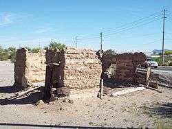 |
1856 | 2 | Tyson's Well | 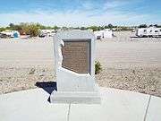 |
1864 |
| 3 | Tyson's Well Stage Station | 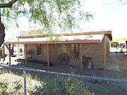 |
1866 | 4 | Oasis Hotel Replica | 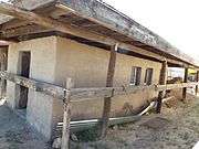 |
1900 |
| 5 | Hi Jolly Monument | 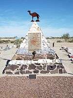 |
1903 | ||||
See also
References
- 1 2
- ↑ "2016 U.S. Gazetteer Files". United States Census Bureau. Retrieved Jul 18, 2017.
- 1 2 "American FactFinder". United States Census Bureau. Retrieved 2014-08-31.
- 1 2 "Population and Housing Unit Estimates". Retrieved June 9, 2017.
- ↑ Richard Josiah Hinton, The Handbook to Arizona: Its Resources, History, Towns, Mines, Ruins, and Scenery, Payot, Upham & Company, San Francisco, 1878
- ↑ Official Map Of The Territory Of Arizona, With All The Recent Explorations. Compiled by Richard Gird C.E. Commissioner. Approved By John N. Goodwin, Governor. In Accordance With An Act Of The Legislature, Approved Oct. 23d. 1864. We hereby certify that this is the Official Map of the Territory of Arizona, and approve the same. Prescott October 12th 1865. (with signed seal dated 1863). Published By A. Gensoul, Pacific Map Depot. No. 511 Montgomery St. San Francisco. Lith. Britton & Co. San Francisco. From davidrumsey.com, accessed on 6/21/2016
- ↑ Sheet No. 1 & 3, Department of Arizona. Revised, 1875. Compiled under the authority of Maj. Gen. J.M. Schofield Commanding Mil. Div. of the Pacific by 1st Lieut. J.C. Mallery Corps of Engrs. Published by authority of The Hon. The Secretary of War in the Office of the Chief Of Engineers U.S. Army Washington D.C. 1876. Drawn by J.W. Ward. From davidrumsey.com, accessed on 6/15/2018
- ↑ Official Map Of The Territory Of Arizona Compiled from Surveys, Reconnaissances and other Sources. By E.A. Eckhoff And P. Riecker, Civil Engineers, 1880. Drawn by Eckhoff & Riecker. The Graphic Co. Photo-Lith. 39 & 41 Park Place, N.Y. Entered ... 1879, by Emil Eckhoff and Paul Riecker ... Washington, D.C., 1880 “Official Map of the Territory of Arizona” showing La Paz - Wikenburg Road and Hardyville - Prescott Road with mileage between locations along the roads, from davidrumsey.com, accessed on 6/21/2016
- ↑ Martha Summerhayes, Vanished Arizona Recollections of the Army Life by a New England Woman, The Salem Press Co., Salem. Mass., 1908.
- ↑ Quartzsite Mining History from minerdiggins.com accessed September 29, 2018.
- ↑ Arizona Atlas and Gazetteer, plate 54, DeLorme, 2001, ISBN 0-89933-325-7
- ↑ Quartzsite (026865) General Climate Summary – Precipitation
- ↑ "Climatography of the United States No. 20 – 1971-2000: Quartzsite, AZ (COOP ID: 026865)" (PDF). National Oceanic and Atmospheric Administration. 2004. Retrieved on August 30, 2014.
- ↑ "Census of Population and Housing". Census.gov. Retrieved June 4, 2016.
- ↑ "American FactFinder". United States Census Bureau. Archived from the original on September 11, 2013. Retrieved 2008-01-31.
- ↑ Community Archived December 14, 2007, at the Wayback Machine.
- ↑ U.S. Camel Corps remembered in Quartzsite, Arizona, Out West Newspaper #18
- ↑ http://www.roadsideamerica.com/tip/32154
- ↑ Avendano, Uriel (2017-01-18). "Park & Rec. considers RC airfield expansion, Peace Trail staging area". Palo Verde Valley Times. Retrieved 2017-01-22.
- ↑ "Public Transportation". Retrieved 2016-10-10.
- ↑ Quartzsite Museum
External links
| Wikivoyage has a travel guide for Quartzsite. |
- Town website
- Quartzsite Times
- Desert Messenger
- Quartzsite information at Desert USA
- BLM camping information
Municipalities and communities of La Paz County, Arizona, United States | ||
|---|---|---|
| Towns | 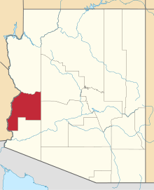 | |
| CDPs | ||
| Populated places | ||
| Indian reservations | ||
| Ghost towns | ||