Brenda, Arizona
| Brenda, Arizona | |
|---|---|
| Census-designated place | |
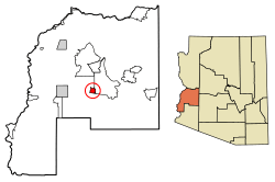 Location of Brenda in La Paz County, Arizona. | |
 Brenda, Arizona Location of Brenda in La Paz County, Arizona. | |
| Coordinates: 33°40′47″N 113°56′41″W / 33.67972°N 113.94472°WCoordinates: 33°40′47″N 113°56′41″W / 33.67972°N 113.94472°W | |
| Country | United States |
| State | Arizona |
| County | La Paz |
| Area[1] | |
| • Total | 6.91 sq mi (17.90 km2) |
| • Land | 6.91 sq mi (17.90 km2) |
| • Water | 0.00 sq mi (0.00 km2) |
| Elevation | 1,375 ft (419 m) |
| Population (2000)[2] | |
| • Total | 730 |
| • Estimate (2016)[3] | N/A |
| Time zone | UTC-7 (Mountain (MST)) |
| Area code(s) | 928 |
| GNIS feature ID | 24335[4] |
Brenda is a census-designated place in La Paz County, Arizona. It is located approximately 13 miles (21 km) east of Quartzsite, (which is on Interstate 10), and 4 miles (6.4 km) northeast on US 60 in Arizona. Its population was 676 as of the 2010 census.[2]
The community lies just east of the Plomosa Mountains; also, it is the closest community to the New Water Mountains Wilderness, and New Water Mountains five air miles to the south.
Brenda is four miles (6.4 km) east of the western terminus of the US 60 (the last community on the highway westbound).
Demographics
| Historical population | |||
|---|---|---|---|
| Census | Pop. | %± | |
| U.S. Decennial Census[5] | |||
References
- ↑ "2016 U.S. Gazetteer Files". United States Census Bureau. Retrieved Jul 18, 2017.
- 1 2 "American FactFinder". United States Census Bureau. Archived from the original on 2013-09-11. Retrieved 2011-05-14.
- ↑ "Population and Housing Unit Estimates". Retrieved June 9, 2017.
- ↑ "Moccasin". Geographic Names Information System. United States Geological Survey.
- ↑ "Census of Population and Housing". Census.gov. Retrieved June 4, 2016.
Municipalities and communities of La Paz County, Arizona, United States | ||
|---|---|---|
| Towns | 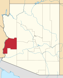 | |
| CDPs | ||
| Populated places | ||
| Indian reservations | ||
| Ghost towns | ||
This article is issued from
Wikipedia.
The text is licensed under Creative Commons - Attribution - Sharealike.
Additional terms may apply for the media files.