Caledonia, Wisconsin
| Caledonia | |
|---|---|
| Village | |
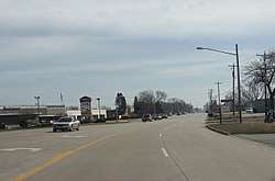 WIS 32 in Caledonia at 4 Mile Road | |
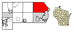 Location of Caledonia in Racine County, Wisconsin. | |
| Coordinates: 42°48′28″N 87°55′27″W / 42.80778°N 87.92417°W | |
| Country | United States |
| State | Wisconsin |
| County | Racine |
| Area[1] | |
| • Total | 48.72 sq mi (126.18 km2) |
| • Land | 45.43 sq mi (117.66 km2) |
| • Water | 3.29 sq mi (8.52 km2) 6.75% |
| Elevation | 659 ft (201 m) |
| Population (2010)[2] | |
| • Total | 24,705 |
| • Estimate (2016)[3] | 24,910 |
| • Density | 543.8/sq mi (210.0/km2) |
| Time zone | UTC-6 (CST) |
| • Summer (DST) | UTC-5 (CDT) |
| ZIP code | 53108 |
| Area code(s) | 262 |
| FIPS code | 55-11950[4] |
| GNIS feature ID | 1582904[5] |
| Website | http://www.caledoniawi.com |
Caledonia is a village in Racine County, Wisconsin, United States. The population was 24,705 at the 2010 census. The residential community of Franksville is located within the village. Franksville was a former census-designated place. The residential neighborhood of Husher is also located within the village.
History
Prior to January 2006, Caledonia was a town. After the state government denied Caledonia's request to become a village, the state legislature enacted a special exemption, allowing Caledonia to proceed. A referendum in 2005 allowed Caledonia to become a village.[6]
Geography
According to the United States Census Bureau, the village has a total area of 48.72 square miles (126.18 km2), of which, 45.43 square miles (117.66 km2) of it is land and 3.29 square miles (8.52 km2) is water.[1]
Demographics
| Historical population | |||
|---|---|---|---|
| Census | Pop. | %± | |
| 1980 | 20,940 | — | |
| 1990 | 20,999 | 0.3% | |
| 2000 | 23,614 | 12.5% | |
| 2010 | 24,705 | 4.6% | |
| Est. 2016 | 24,910 | [3] | 0.8% |
| U.S. Decennial Census[7] | |||
2010 census
As of the census[2] of 2010, there were 24,705 people, 9,629 households, and 7,187 families residing in the village. The population density was 543.8 inhabitants per square mile (210.0/km2). There were 10,056 housing units at an average density of 221.4 per square mile (85.5/km2). The racial makeup of the village was 91.7% White, 2.8% African American, 0.4% Native American, 1.8% Asian, 1.5% from other races, and 1.8% from two or more races. Hispanic or Latino of any race were 5.3% of the population.
There were 9,629 households of which 31.1% had children under the age of 18 living with them, 63.6% were married couples living together, 7.0% had a female householder with no husband present, 4.1% had a male householder with no wife present, and 25.4% were non-families. 20.3% of all households were made up of individuals and 8.4% had someone living alone who was 65 years of age or older. The average household size was 2.55 and the average family size was 2.94.
The median age in the village was 43.5 years. 22.6% of residents were under the age of 18; 6.5% were between the ages of 18 and 24; 23.2% were from 25 to 44; 33.3% were from 45 to 64; and 14.4% were 65 years of age or older. The gender makeup of the village was 49.7% male and 50.3% female.
2000 census
As of the census[4] of 2000, there were 23,614 people, 8,549 households, and 6,805 families residing in the town. The population density was 519.1 people per square mile (200.4/km²). There were 8,839 housing units at an average density of 194.3 per square mile (75.0/km²). The racial makeup of the town was 94.18% White, 1.99% African American, 0.42% Native American, 1.27% Asian, 0.05% Pacific Islander, 0.91% from other races, and 1.18% from two or more races. Hispanic or Latino of any race were 3.12% of the population.
There were 8,549 households out of which 36.7% had children under the age of 18 living with them, 69.4% were married couples living together, 7.2% had a female householder with no husband present, and 20.4% were non-families. 16.1% of all households were made up of individuals and 5.5% had someone living alone who was 65 years of age or older. The average household size was 2.71 and the average family size was 3.04.
In the town the population was spread out with 26.0% under the age of 18, 6.5% from 18 to 24, 30.0% from 25 to 44, 26.7% from 45 to 64, and 10.8% who were 65 years of age or older. The median age was 38 years. For every 100 females, there were 99.8 males. For every 100 females age 18 and over, there were 97.8 males.
The median income for a household in the town was $61,647, and the median income for a family was $68,043. Males had a median income of $46,939 versus $30,859 for females. The per capita income for the town was $26,031. About 2.1% of families and 3.6% of the population were below the poverty line, including 3.1% of those under age 18 and 10.0% of those age 65 or over.
Education
Caledonia is part of Racine Unified School District. There has been an effort to separate into a local independent school district since 2008, culminating in a passed referendum in April, 2015 asking the village to pursue the feasibility of a separation.
Notable people
- Marcel Dandeneau (1931-2014) Wisconsin teacher and state legislator, lived in Caledonia; he served on the Caledonia town board and as chairman of the town board.[8]
References
- 1 2 "US Gazetteer files 2010". United States Census Bureau. Archived from the original on 2012-07-14. Retrieved 2012-11-18.
- 1 2 "American FactFinder". United States Census Bureau. Retrieved 2012-11-18.
- 1 2 "Population and Housing Unit Estimates". Retrieved June 9, 2017.
- 1 2 "American FactFinder". United States Census Bureau. Archived from the original on 2013-09-11. Retrieved 2008-01-31.
- ↑ "US Board on Geographic Names". United States Geological Survey. 2007-10-25. Retrieved 2008-01-31.
- ↑ State's Largest Town Passes Referendum, Becomes Village of Caledonia
- ↑ "Census of Population and Housing". Census.gov. Archived from the original on May 12, 2015. Retrieved June 4, 2015.
- ↑ 'Wisconsin Blue Book 1977,' Biographical Sketch of Marcel Dandeneau, pg. 63
External links
Municipalities and communities of Racine County, Wisconsin, United States | ||
|---|---|---|
| Cities |  | |
| Villages | ||
| Towns | ||
| CDPs | ||
| Unincorporated communities | ||
| Ghost towns/ neighborhoods | ||
| Footnotes | ‡This populated place also has portions in an adjacent county or counties | |
| Central city |  | |
|---|---|---|
| Largest municipalities (over 25,000 in 2010) | ||
| Municipalities (over 10,000 in 2010) | ||
| Smaller municipalities (under 10,000 in 2010) | ||
| Counties | ||
Coordinates: 42°48′28″N 87°55′27″W / 42.80778°N 87.92417°W