Calamba–Pagsanjan Road
| ||||
|---|---|---|---|---|
|
Calamba–Sta. Cruz–Famy Road J.P. Rizal Highway | ||||
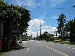 Calamba–Pagsanjan Road in Los Baños, Laguna | ||||
| Route information | ||||
| Maintained by Department of Public Works and Highways | ||||
| Component highways |
| |||
| Major junctions | ||||
| West end |
| |||
| ||||
| East end |
| |||
| Location | ||||
| Major cities | Calamba | |||
| Towns | Los Baños, Bay, Pila, Santa Cruz, Pagsanjan | |||
| Highway system | ||||
|
Roads in the Philippines
| ||||
.svg.png)
The Calamba–Pagsanjan Road, or J. P. Rizal Highway is a two-to-four lane primary highway located in the province of Laguna in the Philippines.
Under the implementation of the new route numbering system by the Department of Public Works and Highways in 2014, the entire road is designated as the National Route 66 (N66), a national primary route of the Philippine highway network.
Route description
It starts from the intersection of Maharlika Highway in Calamba. It will then follow a route that circumscribes the Laguna de Bay, passing through the municipalities of Los Baños, Bay, Pila, the capital of Laguna Province, Santa Cruz, and terminates in Pagsanjan, all in Laguna.
Intersections
The entire route is located in Laguna.
| City/Municipality | km | mi | Destinations | Notes | |
|---|---|---|---|---|---|
| Calamba | Western terminus. Traffic light intersection. | ||||
| Milagrosa–Bucal Bypass Road | Traffic light intersection. | ||||
| Bay | |||||
| Pagsanjan | Eastern terminus. | ||||
| 1.000 mi = 1.609 km; 1.000 km = 0.621 mi | |||||
See also
References
| Expressways |
| ||||||
|---|---|---|---|---|---|---|---|
| National highways |
| ||||||
| Provincial roads and other major roads |
| ||||||
This article is issued from
Wikipedia.
The text is licensed under Creative Commons - Attribution - Sharealike.
Additional terms may apply for the media files.