Mamatid, Cabuyao
| Barangay Mamatid Barangay of Mamatid City of Cabuyao | ||
|---|---|---|
| Urbanized Barangay | ||
 Diocesan Shrine of San Vicente Ferrer | ||
| ||
| Nickname(s): Nayon ng Mamatid, Barrio Mamatid | ||
| Country |
| |
| Region | CALABARZON (Region IV-A) | |
| Province | Laguna | |
| City | Cabuyao City | |
| Puroks | 3 | |
| Incorporated (settlement) | 1571 | |
| Incorporated (barrio) | 1946 | |
| Government | ||
| • Type | Sangguniang Barangay, with a chairman as its head supported by seven barangay councilors | |
| • Barangay Chairman | Gabriel C. Bariring II | |
| Area | ||
| • Urbanized Barangay | 2.6 km2 (1.00387 sq mi) | |
| • Urban | 2.6 km2 (1.00387 sq mi) | |
| Population (May 2010) | ||
| • Urbanized Barangay | 50,213 | |
| • Density | 19,000/km2 (50,000/sq mi) | |
| • Urban | 50,213 | |
| • Urban density | 19,000/km2 (50,000/sq mi) | |
| Time zone | UTC+8 (PST) | |
| • Summer (DST) | Manila | |
| Zip Code | 4025 | |
| Area code(s) | 049 | |
| Languages | Tagalog and English | |
| Demonym | Mamateños | |

Mamatid (Ma-ma-tíd), officially known as Barangay Mamatid (PSGC: 043404009), is one of the eighteen urbanized[1] barangays comprising the city of Cabuyao in the province of Laguna, Philippines. It lies about 6.5 kilometers from the city proper of Cabuyao and is situated at the eastern portion of the city. According to the 2010 Census,[2] it has a population of 50,213 inhabitants (this grew from 37,166 in Census 2007),[3] making it ranked as the most populous barangay in Cabuyao. This is due to a large influx of people migrating to many subdivisions located in the barangay.
Barangay Mamatid is popular for its three college schools; many private schools, including Catholic schools, from pre-school to high school; seven day care centers; and a public elementary school, with many students.
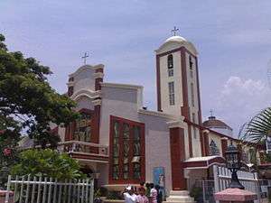
The barangay is known for its Diocesan Shrine dedicated to Saint Vincent Ferrer, which many devotees from other provinces and neighboring towns and barangays come to visit.
Political division
It is politically subdivided into three Puroks:
|
Purok I
|
Purok II
|
Purok III
|
Geography
Land Area
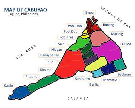
The total land area of Barangay Mamatid is 260 hectares or 2.6 square kilometers (km2), ranking ninth largest out of the eighteen barangays in Cabuyao. It lies about 6.5 kilometers away from the town proper and is situated at the eastern portion of the city.[4]
Location
It is located at the western portion of Laguna de Bay, the country's largest lake; southwest of Brgy. Uwisan and west of Brgy. Banlic in Calamba City; north of Brgy. Banlic; northeast of Brgy. San Isidro; east of Brgy. Gulod; and southeast of Brgy. Baclaran in Cabuyao City.
It is one of the six "along the lake" barangays of the town, along with Barangays Baclaran, Gulod, Marinig, Butong and Bigaa.[4]
Climate

Seasons
The rainfall of Barangay Mamatid is characterized by two pronounced seasons, the wet and dry seasons. The wet season is from June to November, and the relatively dry season lasts from December to May. The average rainfall is about 2,000 mm of rain falling per year, with about 150 rainy days.[5]
Temperature
The coldest months are from November to January, and the warmest month on the record is May. On average, a 12 °C temperature difference exists between the warmest and coolest months. The mean annual temperature is a warm 27.5 °C.[5]
Humidity
The annual relative humidity is 70%. The most humid months are June, July, August and September, with the normal relative humidity registered at 84%, while April and May are the driest at 70%.[5]
Demography
| Population Census of Mamatid | ||
|---|---|---|
| Year | Pop. | ±% p.a. |
| 2000 | 10,020 | — |
| 2007 | 37,166 | +19.82% |
| 2010 | 50,213 | +11.57% |
According to the 2010 Census,[2] it has a population of 50,213 inhabitants, which grew from 37,166 in the 2007 Census[3] and 10,020 in the 2000 Census. Mamatid is currently the most populous barangay of the city.
| No. | Barangay | Rank | Population (2007) | Population (2010) | Population Density (2010) | Annual Growth Rate (Average) |
|---|---|---|---|---|---|---|
| 1 | Baclaran | 9th | 12,683 | 12,192 | 6,985/km2 | |
| 2 | Banay-Banay | 4th | 17,419 | 21,934 | 7.073/km2 | |
| 3 | Banlic | 7th | 9,707 | 12,675 | 5,511/km2 | |
| 4 | Bigaa | 10th | 8,649 | 10,051 | 4,807/km2 | |
| 5 | Butong | 8th | 12,274 | 12,360 | 7,630/km2 | |
| 6 | Casile | 16th | 1,555 | 2,128 | 669/km2 | |
| 7 | Diezmo | 15th | 2,689 | 2,681 | 1,686/km2 | |
| 8 | Gulod | 11th | 10,127 | 9,417 | 2,304/km2 | |
| 9 | Mamatid | 1st | 37,166 | 50,213 | 19,313/km2 | |
| 10 | Marinig | 2nd | 25,619 | 37,169 | 9,494/km2 | |
| 11 | Niugan | 3rd | 21,993 | 26,807 | 7,615/km2 | |
| 12 | Pittland | 18th | 1,627 | 1,740 | 598/km2 | |
| 13 | Pulo | 6th | 13,193 | 15,124 | 5,041/km2 | |
| 14 | Sala | 12th | 7,491 | 8,275 | 5,353/km2 | |
| 15 | San Isidro | 5th | 15,495 | 18,145 | 5,767/km2 | |
| 16 | Barangay I Poblacion | 14th | 2,589 | 2,839 | 12,334/km2 | |
| 17 | Barangay II Poblacion | 17th | 1,947 | 1,840 | 7,886/km2 | |
| 18 | Barangay III Poblacion | 13th | 3,153 | 2,846 | 12,034/km2 | |
| TOTAL | 6th | 205,376 | 248,436 | 5,700/km2 |
Barangay income
Barangay Mamatid has an income per capita of PhP 15,973,620.00 (for fiscal year 2012). It is currently the fastest-growing barangay of the city.
Churches and chapels
Parish church
San Vicente Ferrer Parish - Parroquia de Mamatid (Mamatid Parish) was founded in September 1946 under the Archdiocese of Lipa, which later became under the Diocese of San Pablo San Pablo City, Laguna. It was named in honor of Saint Vincent Ferrer, the barangay's patron saint. A large crowd went there on his feast day (April 5). It is the first barangay church to become a parish in Laguna.
Shrine
The Diocesan Shrine of San Vicente Ferrer was declared on March 26, 2010 in the celebration of the consecration and dedication of the parish church.
Chapels
Chapels under the supervision of San Vicente Ferrer Parish are:
- Immaculate Concepcion Chapel (Brgy. Baclaran)
- Saint Raphael Archangel Mini Parish (Brgy. Gulod)
- The Risen Lord Chapel (Mabuhay City Subdivision - Phase 1, Brgy. Mamatid)
- Saint Joseph the Worker Chapel (Mabuhay City Subdivision - Phase 5, Brgy. Mamatid)
- Mabuhay Mini Chapel (Mabuhay City Subdivision - Phase 3, Brgy. Mamatid)
- San Vicente ferrer parish church
Other churches
- United Church of Christ in the Philippines (Brgy. Mamatid)
- Members, Church of God International (Ang Dating Daan) (Mabuhay City Subd. Brgy. Mamatid)
Barangay officials (2013-2016)
Barangay Captain: Gabriel C. Bariring II
Sangguniang Barangay members:
- Ambell M. Himpisao
- Justino H. Lapaz
- Jervis R. Himpisao
- Emmil C. Lapidario
- Gil L. Naval III
- Fritz Gail P. Antioquia
See also
References
- ↑ Philippine Standard Geographic Code Archived 2011-11-14 at the Wayback Machine.
- 1 2 "Final Results - 2010 Census of Population". census.gov.ph. Archived from the original on 2012-07-07. Retrieved 2012-06-16.
- 1 2 2007 Census table for Laguna Archived 2011-06-07 at the Wayback Machine. - National Statistics Office
- 1 2 Cabuyao, Laguna/Barangay Location Archived 2012-01-28 at the Wayback Machine.
- 1 2 3 Cabuyao, Laguna - physical characteristics Archived 2010-10-29 at the Wayback Machine.
External links
- Mamatid Official Website
- Mamatid Map | Philippines Google Satellite Maps
- Official Website of the City of Cabuyao
- Cabuyao Laguna Site
- The Spirit of Cabuyao
Places adjacent to Mamatid, Cabuyao | ||||||||||
|---|---|---|---|---|---|---|---|---|---|---|
| ||||||||||
| Aplaya | |
|---|---|
| Central District | |
| Mamatid District | |
| West District | |
| City Proper District | |
Barangays in italics are unofficial
| |
| Geography |
|  | |||
|---|---|---|---|---|---|
| City | |||||
| Officials | |||||
| History |
| ||||
| Barangays | |||||
| Notable people | |||||
| |||||
Coordinates: 14°16′42″N 121°7′29″E / 14.27833°N 121.12472°E