Burton Parish, New Brunswick
| Burton | |
|---|---|
| Parish | |
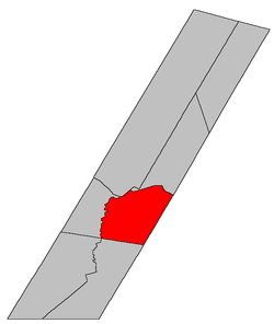 Location within Sunbury County, New Brunswick | |
| Country |
|
| Province |
|
| County | Sunbury County |
| Established | 1765 |
| Area[1] | |
| • Land | 259.48 km2 (100.19 sq mi) |
| Population (2011)[1] | |
| • Total | 5,421 |
| • Density | 20.9/km2 (54/sq mi) |
| • Pop 2006-2011 |
|
| • Dwellings | 1,983 |
| Time zone | UTC-4 (AST) |
| • Summer (DST) | UTC-3 (ADT) |
Burton is a Canadian parish in Sunbury County, New Brunswick.[2]
History
Burton Parish first established in 1765 as a Nova Scotia township: named for Brigadier General Ralph Burton who served at the capture of Fort Louisbourg in 1758 and the capture of Québec in 1759: Burton became a parish in New Brunswick in 1786: included part of Blissville Parish until 1834.
Delineation
Burton Parish is defined in the Territorial Division Act[3] as being bounded:
- Southeast by the County line; southwest by the prolongation southeasterly of the southwest line of Lincoln Parish to the Queens County line; northwest by the Oromocto River and northeast by the Saint John River, including Gilbert and Ox Islands.
Communities
Parish population total does not include incorporated municipalities (in bold):
|
|
|
|
Bodies of water & Islands
This is a list of rivers, lakes, streams, creeks, marshes and Islands that are at least partially in this parish
Demographics
Access Routes
Highways and numbered routes that run through the parish, including external routes that start or finish at the parish limits:[6]
|
|
|
|
See also
References
- 1 2 2011 Statistics Canada Census Profile: Burton Parish, New Brunswick
- ↑ New Brunswick Provincial Archives - Burton Parish
- ↑ "Territorial Division Act (R.S.N.B. 1973, c. T-3)". Government of New Brunswick website. Retrieved 17 August 2016.
- ↑ Statistics Canada: 2001, 2006 census
- ↑ Profile: Burton Parish, New Brunswick
- ↑ Atlantic Canada Back Road Atlas ISBN 978-1-55368-618-7
External links
Places adjacent to Burton Parish, New Brunswick | |
|---|---|
| Subdivisions | |
|---|---|
| Cities | |
| Counties | |
| |