Brigalow Belt
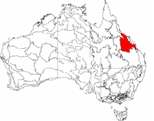
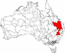
The Brigalow Belt is a wide band of acacia wooded grassland that runs between tropical rainforest of the coast and the semi-arid interior of Queensland, Australia. See Interim Biogeographic Regionalisation for Australia for the IBRA definitions of the Brigalow Belt South (BBS) and the Brigalow Belt North (BBN) bioregions. The Northern and Southern Brigalow Belts are two of the 85 bioregions across Australia and the 15 bioregions in Queensland. Together they form most of the Brigalow tropical savanna ecoregion.
Location and description
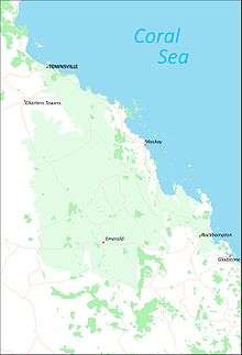
The Northern Brigalow Belt covers just over 13.5 million hectares and reaches down from just north of Townsville, to Emerald and Rockhampton on the tropic, while the Southern Brigalow Belt runs from there down to the Queensland/New South Wales border and a little beyond until the habitat becomes the eucalyptus dominated Eastern Australian temperate forests.
This large, complex strip of countryside covers an area of undulating to rugged slopes, consisting of ranges as well as plains of ancient sand and clay deposits, basalt and alluvium. The Northern Brigalow Belt includes the coal producing Bowen Basin with the nearby Drummond Basin and the fertile Peak Downs areas while the southern belt runs into the huge Great Artesian Basin with the sandstone gorges of the Carnarvon Range of the Great Dividing Range separating the two areas. The south-west side includes the farming area of Darling Downs.
A number of important rivers drain the Brigalow Belt mostly running eastwards towards the coast, including the large Fitzroy River system and the Belyando and Burdekin rivers near the tropics. The south-western areas drain westwards into the Murray–Darling basin via the Maranoa, Warrego and Condamine Rivers.
The northern belt has tropical summer rains and warm weather all year round, while south of the tropic the winter is slightly cooler and there is more year-round rainfall as well as the summer. All along the belt the interior with less than 500 mm of rainfall per year is drier than the coast which may have 750 mm and more.
Flora
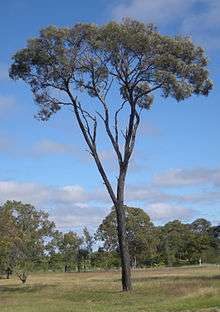
The characteristic plant communities are woodlands of highly water stress tolerant brigalow, a slender acacia tree which thrives on the clay soil and once covered much of the area especially the fertile lowlands. However most of the brigalow has been cleared to make agricultural land and eucalypt woodlands of silver-leaved and narrow-leaved ironbarks, poplar box and other boxes, blackbutt and coolibah are now more intact especially on the higher slopes.[1][2][3][4][5][6]
Dichanthium grasslands are another typical habitat of the area while pockets of thicker woodland of brigalow mixed with Casuarina cristata and Ooline occur in moister valleys and vine thickets, wetlands and softwood scrubs are sometimes found although in their undeveloped state, these specialised micro-habitats are rare today. There is a particularly rich variety of habitats in areas such as Isla Gorge and Blackdown Tableland in the sandstone belt of the Carnarvon Range. The Northern Brigalow Belt is one of fifteen national biodiversity hotspots in Australia.[7]
Fauna
The region is home to the unadorned rock-wallaby and the black-striped wallaby, which lives in the areas of vine thicket along with a wingless dung beetle (Onthophagus apterus). Two endangered mammals are found in the Brigalow Belt; the bridled nail-tail wallaby in Taunton and Idalia National Parks, and the burrowing northern hairy-nosed wombat in the grassland and eucalyptus of Epping Forest National Park. Birds found here include black-throated finch and russet-tailed thrush, while endemic reptiles include the Fitzroy River turtle.
Threats and preservation
Much of the brigalow woodland has been cleared or radically reduced to the extent that some wildlife, failing to thrive in the altered environment, has become extinct here with a number of the remaining communities threatened or endangered. The clearance of brigalow and poplar box is ongoing as there are a number of nature reserves of which do protect the various types of habitat found in the Belt including brigalow and eucalyptus woodland, grassland, vine thicket, high peaks, sandstone gorges and wetlands however these tend to be located on the sandstone uplands rather than the fertile lowlands, where the brigalow woodlands are still vulnerable to clearance and are often limited to small areas of parkland. The grasslands of the region are also under threat from introduced pasture grasses such as buffelgrass and weeds such as Congress weed. One particular threat comes from dams and weirs on the Dawson River.
Protected areas
A little more than two per cent of the Brigalow Belt lies within national parks and other protected areas.[8] The largest national parks in the Brigalow Belt are: Taunton (the largest at 115 km2); Epping Forest, Dipperu, Bowling Green Bay, Goodedulla National Park, Chesterton Range National Park, Homevale National Park, Blackdown Tableland National Park, Expedition National Park, and Carnarvon National Park.
Subregions
IBRAsubregions of the Brigalow Belt include Townsville Plains, Bogie River Hills, Cape River Hills, Beucazon Hills, Wyarra Hills, Northern Bowen Basin, Belyando Downs, Upper Belyando Floodout, Anakie Inlier, Basalt Downs, Isaac–Comet Downs, Nebo–Connors Ranges, South Drummond Basin and Marlborough Plains.
| IBRA regions and subregions: IBRA7 | |||||
|---|---|---|---|---|---|
| IBRA region / subregion | IBRA code | Area | States | Location in Australia | |
| Brigalow Belt North | BBN | 33,790,510 hectares (83,498,200 acres) | Qld | | |
| Townsville Plains | BBN01 | 763,495 ha (1,886,640 acres) | |||
| Bogie River Hills | BBN02 | 1,054,392 ha (2,605,460 acres) | |||
| Cape River Hills | BBN03 | 747,393 ha (1,846,850 acres) | |||
| Beucazon Hills | BBN04 | 95,821 ha (236,780 acres) | |||
| Wyarra Hills | BBN05 | 397,935 ha (983,320 acres) | |||
| Northern Bowen Basin | BBN06 | 1,316,957 ha (3,254,270 acres) | |||
| Belyando Downs | BBN07 | 1,772,127 ha (4,379,020 acres) | |||
| Upper Belyando Floodout | BBN08 | 466,275 ha (1,152,190 acres) | |||
| Anakie Inlier | BBN09 | 382,284 ha (944,640 acres) | |||
| Basalt Downs | BBN10 | 1,274,731 ha (3,149,930 acres) | |||
| Isaac-Comet Downs | BBN11 | 2,693,397 ha (6,655,530 acres) | |||
| Nebo-Connors Ranges | BBN12 | 449,269 ha (1,110,170 acres) | |||
| South Drummond Basin | BBN13 | 1,009,244 ha (2,493,900 acres) | |||
| Marlborough Plains | BBN14 | 1,250,611 ha (3,090,330 acres) | |||
| IBRA regions and subregions: IBRA7 | |||||
|---|---|---|---|---|---|
| IBRA region / subregion | IBRA code | Area | States | Location in Australia | |
| Brigalow Belt South | BBS | 27,219,776 hectares (67,261,530 acres) | Qld / NSW | | |
| Claude River Downs | BBS01 | 1,026,214 ha (2,535,830 acres) | |||
| Woorabinda | BBS02 | 749,785 ha (1,852,760 acres) | |||
| Boomer Range | BBS03 | 220,541 ha (544,970 acres) | |||
| Mount Morgan Ranges | BBS04 | 1,275,970 ha (3,153,000 acres) | |||
| Callide Creek Downs | BBS05 | 30,133 ha (74,460 acres) | |||
| Arcadia | BBS06 | 715,288 ha (1,767,520 acres) | |||
| Dawson River Downs | BBS07 | 982,807 ha (2,428,570 acres) | |||
| Banana-Auburn Ranges | BBS08 | 1,547,555 ha (3,824,090 acres) | |||
| Buckland Basalts | BBS09 | 281,306 ha (695,120 acres) | |||
| Carnarvon Ranges | BBS10 | 2,263,686 ha (5,593,690 acres) | |||
| Taroom Downs | BBS11 | 652,005 ha (1,611,140 acres) | |||
| Southern Downs | BBS12 | 4,264,666 ha (10,538,220 acres) | |||
| Barakula | BBS13 | 1,301,712 ha (3,216,600 acres) | |||
| Dulacca Downs | BBS14 | 162,442 ha (401,400 acres) | |||
| Weribone High | BBS15 | 966,510 ha (2,388,300 acres) | |||
| Tara Downs | BBS16 | 511,339 ha (1,263,550 acres) | |||
| Eastern Darling Downs | BBS17 | 1,697,945 ha (4,195,710 acres) | |||
| Inglewood Sandstones | BBS18 | 1,219,008 ha (3,012,230 acres) | |||
| Moonie-Commoron Floodout | BBS19 | 750,661 ha (1,854,920 acres) | |||
| Moonie-Barwon Interfluve | BBS20 | 765,231 ha (1,890,930 acres) | |||
| Northern Basalts | BBS21 | 624,671 ha (1,543,600 acres) | |||
| Northern Outwash | BBS22 | 700,241 ha (1,730,330 acres) | |||
| Pilliga Outwash | BBS23 | 535,392 ha (1,322,980 acres) | |||
| Pilliga | BBS24 | 1,732,137 ha (4,280,200 acres) | |||
| Liverpool Plains | BBS25 | 941,752 ha (2,327,120 acres) | |||
| Liverpool Range | BBS26 | 521,960 ha (1,289,800 acres) | |||
| Talbragar Valley | BBS27 | 203,894 ha (503,830 acres) | |||
| Narrandool | BBS28 | 303,754 ha (750,590 acres) | |||
References
- ↑ Fensham, R.J.; McCosker, J.C.; Cox, M.J. (1998). "Estimating clearance of Acacia-dominated ecosystems in central Queensland using land-system mapping data". Australian Journal of Botany. 46: 305–319. doi:10.1071/bt96129.
- ↑ Young, P.A.R., B.A. Wilson, J.C. McCosker, R.J. Fensham, G. Morgan, and P. M. Taylor. 1999. Brigalow Belt. Pages 11/1-11/81 in P. Sattler and R. Williams, editors. The Conservation Status of Queensland's Bioregional Ecosystems. Environmental Protection Agency, Brisbane, Australia
- ↑ Thackway, R., and I.D. Creswell. 1995. An Interim Biogeographic Regionalisation for Australia: A framework for establishing a national system of reserves, Version 4. Australian Nature Conservation Agency, Canberra, Australia.
- ↑ Arnold, S.; Thornton, C.; Baumgartl, T. (2012). "Ecohydrological feedback as a land restoration tool in the semi-arid Brigalow Belt, QLD, Australia". Agriculture, Ecosystems and Environment. 163: 61–71. doi:10.1016/j.agee.2012.05.020.
- ↑ Arnold, S., P. Audet, D. Doley, and T. Baumgartl. 2013. Hydropedology and ecohydrology of the Brigalow Belt, Australia: opportunities for ecosystem rehabilitation in semi-arid environments. Vadose Zone Journal, https://www.soils.org/publications/vzj/articles/12/4/vzj2013.03.0052?highlight=&search-result=1)
- ↑ Arnold, S., Y. Kailichova, and T. Baumgartl. 2014. Germination of Acacia harpophylla (Brigalow) seeds in relation to soil water potential: implications for rehabilitation of a threatened ecosystem. PeerJ, https://peerj.com/articles/268/
- ↑ "Brigalow tropical savanna". Terrestrial Ecoregions. World Wildlife Fund.
- ↑ "Expedition National Park: Nature, culture and history". Department of National Parks, Recreation, Sport and Racing. Retrieved 9 July 2013.
- "Australia's Biogeographical Regions". Department of the Environment, Water, Heritage and the Arts, Australian Government. Retrieved 2009-01-13.
- "Australian Natural Resource Atlas". Department of the Environment, Water, Heritage and the Arts, Australian Government. Archived from the original on 2009-07-04.
- Sattler, P. S. and R. D. Williams (1999) (eds) The Conservation Status of Queensland’s Bioregional ecosystems. Environmental Protection Agency, Brisbane
- IBRA Version 6.1 data. (Search in "Title" for "IBRA").