Burt Plain
| Burt Plain Northern Territory | |||||||||||||||
|---|---|---|---|---|---|---|---|---|---|---|---|---|---|---|---|
 | |||||||||||||||
| Area | 73,797.19 km2 (28,493.3 sq mi) | ||||||||||||||
| |||||||||||||||
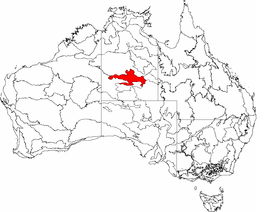
Burt Plain, an interim Australian bioregion, is located in the Northern Territory,[1][2] and comprises 7,379,719 hectares (18,235,680 acres).[3]
The bioregion has the code BRT.[3] There are four subregions.[3]
| IBRA regions and subregions: IBRA7 | ||||
|---|---|---|---|---|
| IBRA region / subregion | IBRA code | Area | States | Location in Australia |
| Burt Plain | BRT | 7,379,719 hectares (18,235,680 acres) | NT | |
| Yuendumu | BRT01 | 2,931,061 ha (7,242,810 acres) | ||
| Atartinga | BRT02 | 3,531,111 ha (8,725,570 acres) | ||
| Mount Chapple | BRT03 | 390,981 ha (966,140 acres) | ||
| Dulcie | BRT04 | 526,567 ha (1,301,180 acres) | ||
See also
References
- ↑ Environment Australia. "Revision of the Interim Biogeographic Regionalisation for Australia (IBRA) and Development of Version 5.1 - Summary Report". Department of the Environment and Water Resources, Australian Government. Archived from the original on 2006-09-05. Retrieved 2007-01-31.
- ↑ IBRA Version 6.1 data
- 1 2 3 "Interim Biogeographic Regionalisation for Australia (IBRA7) regions and codes". Department of Sustainability, Environment, Water, Population and Communities. Commonwealth of Australia. 2012. Retrieved 13 January 2013.
Further reading
- Thackway, R and I D Cresswell (1995) An interim biogeographic regionalisation for Australia : a framework for setting priorities in the National Reserves System Cooperative Program Version 4.0 Canberra : Australian Nature Conservation Agency, Reserve Systems Unit, 1995. ISBN 0-642-21371-2
| Topics | ||
|---|---|---|
| Regions | ||
| Major settlements | ||
Northern Territory portal | ||
This article is issued from
Wikipedia.
The text is licensed under Creative Commons - Attribution - Sharealike.
Additional terms may apply for the media files.