Carnarvon Range
| Carnarvon | |
|---|---|
 | |
| Elevation | 694 metres (2,277 ft) |
| Dimensions | |
| Length | 160 km (99 mi) |
| Geography | |
| Country | Australia |
| State | Queensland |
| Region | Central Queensland |
| Range coordinates | 25°23.8′S 148°36.8′E / 25.3967°S 148.6133°ECoordinates: 25°23.8′S 148°36.8′E / 25.3967°S 148.6133°E |
| Parent range | Great Dividing Range |
The Carnarvon Range is a mountain range in Central Queensland, Australia. It is a plateau section of the Great Dividing Range. The Carnarvon Range is 160 km in length.[1] It was first explored by Ludwig Leichhardt but named by Thomas Mitchell after the 4th Earl of Carnarvon.
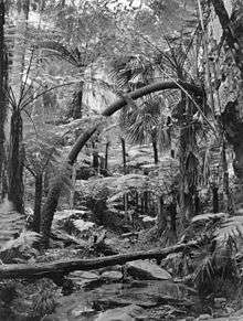
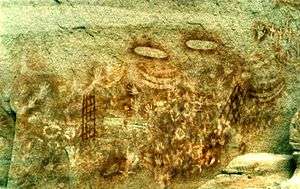
North eastern parts of the range have formed a plateau known as the Consuelo Tableland. The plateau contains Aboriginal paintings and sandstone gorges, including the Carnarvon Gorge. Part of the range is protected within the Carnarvon National Park.
The range marks the northernmost limits of the Murray-Darling Basin and is the headwaters for a number of rivers including the Fitzroy River, Warrego River, Dawson River, Merivale River and the Nogoa River.
The cycad species Macrozamia moorei is a native plant species found naturally in the Carnarvon Range.
See also
References
- ↑ "Carnarvon Range (plateau, Queensland, Australia)". Encyclopædia Britannica. Britannica Online Encyclopedia. Retrieved 2009-06-22.