Brasted
| Brasted | |
|---|---|
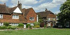 The village green at Brasted | |
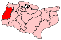
 Brasted Brasted shown within Kent | |
| Population | 1,429 (2011 census)[1] |
| Civil parish |
|
| District | |
| Shire county | |
| Region | |
| Country | England |
| Sovereign state | United Kingdom |
| Post town | WESTERHAM |
| Postcode district | TN16 |
| Dialling code | 01959 |
| Police | Kent |
| Fire | Kent |
| Ambulance | South East Coast |
| EU Parliament | South East England |
Brasted /ˈbreɪstɛd/[2] is a village and civil parish in the Sevenoaks District of Kent, England. Brasted lies on the A25 road, between Sundridge and Westerham; the road is named Westerham Road, High Street and Main Road as it passes through the village east to west. Brasted is 6 km west of Sevenoaks town. The parish includes the settlements of Brasted Chart and Toys Hill, and had a population of 1321 (2001 census). The village has a number of 18th-century houses, and several antique shops. The parish church is dedicated to St Martin.
The name is recorded as Briestede in 1086 and as Bradestede around 1100; it is from Old English brād + stede and means "broad place".[3] In the 19th century Napoleon III lived in Brasted Place (one of only two Robert Adam houses in Kent). Another famous resident was John Turton, physician to King George III.[4]
Brasted had a railway station on the branch line running between Westerham and Dunton Green that opened in 1881 and closed in 1961. Australian soft-drink manufacturer George Marchant was born in Brasted in 1857. During the Second World War the local pub, the White Hart, was popular with RAF fighter pilots stationed at nearby Biggin Hill.
Just to the north of Brasted the M25 motorway passes in a west-east direction; the River Darent has its source near the village.
Brasted Chart
Brasted Chart is a hamlet within the civil parish of Brasted. It lies to the south of Brasted and the north of Four Elms. Its road, Chart Lane, leads to another hamlet called Toys Hill to the south. There is no chapel or church; however there are numerous Grade II listed buildings, the former stables and coach house and linking wall and mounting block to the south west of the house of Foxwold. Similarly, all the buildings (Cottage, Oast House, Piggery and former dairy, now a base camp for private group bookings and working holidays) at Outridge Farm (owned by the National Trust) have Grade II listed building status. The Oast Houses are unique in that the cowls are octagonal, in comparison to the usual conical shape found in both Kent and Sussex.[5]
Nearest Settlements
Nearest settlements | |
|---|---|
References
- ↑ "Civil Parish population 2011". Neighbourhood Statistics. Office for National Statistics. Retrieved 18 September 2016.
- ↑ G.M. Miller, BBC Pronouncing Dictionary of British Names (Oxford UP, 1971), p. 20.
- ↑ A.D. Mills, Dictionary of English Place-Names (Oxford UP, 2nd ed., 1998), p. 51.
- ↑ John Newman. West Kent and the Weald. The “Buildings of England” Series, First Edition, Sir Nikolaus Pevsner and Judy Nairn, eds. (London: Penguin, 1969), 171
- ↑ "National Heritage List, List Entries IDs 1085841, 1249480, 1263743, 1249480". English Heritage. Retrieved 30 April 2012.
External links
| Wikimedia Commons has media related to Brasted. |