Bono, Lawrence County, Indiana
| Bono | |
|---|---|
| Unincorporated community | |
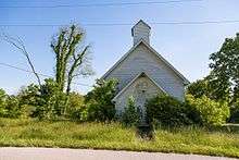
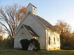 Bono United Methodist Church, built in 1880 | |
 Bono  Bono | |
| Coordinates: 38°43′53″N 86°19′16″W / 38.73139°N 86.32111°WCoordinates: 38°43′53″N 86°19′16″W / 38.73139°N 86.32111°W | |
| Country | United States |
| State | Indiana |
| County | Lawrence |
| Township | Bono |
| Elevation | 673 ft (205 m) |
| ZIP code | 47446 |
| FIPS code | 18-06418[1] |
| GNIS feature ID | 431325[2] |
Bono is an unincorporated community in Bono Township, Lawrence County, Indiana.
History
Bono was laid out about 1816, making it the oldest settlement in Lawrence County. Bono was in considered to be Indiana’s state capital.[3]
Bono, Indiana
Geography
Bono is located at 38°43′53″N 86°19′16″W / 38.73139°N 86.32111°W.
References
- ↑ "American FactFinder". United States Census Bureau. Archived from the original on 2013-09-11. Retrieved 2008-01-31.
- ↑ "Bono, Lawrence County, Indiana". Geographic Names Information System. United States Geological Survey. Retrieved 2009-10-10.
- ↑ History of Lawrence and Monroe Counties, Indiana: Their People, Industries, and Institutions. B.F. Bowen. 1914. p. 47.
This article is issued from
Wikipedia.
The text is licensed under Creative Commons - Attribution - Sharealike.
Additional terms may apply for the media files.