Blythewood, South Carolina
| Blythewood, South Carolina | |
|---|---|
| Town | |
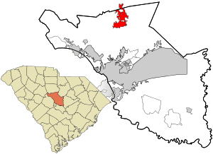 Location in Richland County and the state of South Carolina. | |
| Coordinates: 34°13′5″N 80°59′5″W / 34.21806°N 80.98472°WCoordinates: 34°13′5″N 80°59′5″W / 34.21806°N 80.98472°W | |
| Country | United States |
| State | South Carolina |
| Counties | Richland, Fairfield |
| Area | |
| • Total | 9.8 sq mi (25.3 km2) |
| • Land | 9.7 sq mi (25.1 km2) |
| • Water | 0.08 sq mi (0.2 km2) |
| Elevation | 499 ft (152 m) |
| Population (2010) | |
| • Total | 2,034 |
| • Density | 210/sq mi (80/km2) |
| Time zone | UTC-5 (EST) |
| • Summer (DST) | UTC-4 (EDT) |
| ZIP code | 29016 |
| Area code(s) | 803 |
| FIPS code | 45-07255[1] |
| GNIS feature ID | 1245688[2] |
| Website |
www |
Blythewood is a town in Richland and Fairfield counties, South Carolina, United States. The population was 2,034 at the 2010 census,[3] up from 170 in 2000.[4] It is part of the Columbia, South Carolina, Metropolitan Statistical Area.
Blythewood Road is one of the main thoroughfares, intersecting Interstate 77 at Exit 27. U.S. Route 21 also goes through Blythewood, Also Intersecting Interstate 77 At Exit 24.
History
The George P. Hoffman House was added to the National Register of Historic Places in 1986.[5]
Geography
Blythewood is located at 34°13′5″N 80°59′5″W / 34.21806°N 80.98472°W (34.217992, -80.984618)[6] in the Piedmont region.
According to the United States Census Bureau, the town has a total area of 9.8 square miles (25.3 km2), of which 9.7 square miles (25.1 km2) is land and 0.077 square miles (0.2 km2), or 0.79%. is water.[3]
"Blythewood" is the mailing address for over 80 square miles (210 km2) of unincorporated Richland County, using the 29016 ZIP code. The area includes several planned subdivisions, both with and without property owners associations. Law enforcement in both the unincorporated area and the town proper is provided by the Richland County Sheriffs Department.
Demographics
| Historical population | |||
|---|---|---|---|
| Census | Pop. | %± | |
| 1980 | 92 | — | |
| 1990 | 164 | 78.3% | |
| 2000 | 170 | 3.7% | |
| 2010 | 2,034 | 1,096.5% | |
| Est. 2016 | 3,099 | [7] | 52.4% |
| U.S. Decennial Census[8] | |||
As of the census of 2010, there were 2,034 people, 723 households, and 608 families residing in the town. The population density was 209.7 people per square mile (81.0/km²). There were 782 housing units at an average density of 80.6 per square mile (31.2/km²). The racial makeup of the town was 69.8% White, 27.0% African American, 0.4% American Indian or Alaska Native, 1.0%% Asian, 0.1% Native Hawaiian or Other Pacific Islander, 0.2% some other race, and 1.5% from two or more races. Hispanic or Latino of any race were 2.8% of the population.[9]
There were 723 households out of which 42.5% had children under the age of 18 living with them, 71.0% were headed by married couples living together, 9.4% had a female householder with no husband present, and 15.9% were non-families. 13.4% of all households were made up of individuals, and 4.6% were someone living alone who was 65 years of age or older. The average household size was 2.81 and the average family size was 3.08.[9]
In the town, the population was spread out with 27.6% under the age of 18, 5.7% from 18 to 24, 24.4% from 25 to 44, 33.4% from 45 to 64, and 8.8% who were 65 years of age or older. The median age was 40.6 years. For every 100 females, there were 93.9 males. For every 100 females age 18 and over, there were 92.9 males.[9]
For the period 2007–2011, the estimated median annual income for a household in the town was $105,234, and the median income for a family was $118,611. Males had a median income of $78,563 versus $43,036 for females. The per capita income for the town was $46,685. About 0.9% of families and 1.4% of the population were below the poverty line, including 0.0% of those under the age of 18 and 9.3% of those 65 or over.[10]
Climate
Climate is characterized by warm temperatures and moderate precipitation throughout the year. The Köppen Climate Classification subtype for this climate is "Cfa" (Humid Subtropical Climate).[11]
| Climate data for Blythewood | |||||||||||||
|---|---|---|---|---|---|---|---|---|---|---|---|---|---|
| Month | Jan | Feb | Mar | Apr | May | Jun | Jul | Aug | Sep | Oct | Nov | Dec | Year |
| Average high °C (°F) | 12 (54) |
14 (58) |
19 (66) |
24 (75) |
28 (82) |
31 (88) |
33 (91) |
32 (89) |
29 (84) |
24 (75) |
19 (66) |
14 (57) |
23 (74) |
| Average low °C (°F) | 0 (32) |
2 (35) |
6 (42) |
10 (50) |
15 (59) |
19 (66) |
21 (70) |
21 (69) |
17 (63) |
11 (52) |
6 (43) |
2 (35) |
11 (51) |
| Average precipitation mm (inches) | 107 (4.2) |
94 (3.7) |
117 (4.6) |
79 (3.1) |
84 (3.3) |
117 (4.6) |
132 (5.2) |
114 (4.5) |
94 (3.7) |
81 (3.2) |
74 (2.9) |
86 (3.4) |
1,179 (46.4) |
| Average precipitation days | 10 | 9 | 9 | 8 | 8 | 9 | 10 | 9 | 8 | 6 | 7 | 9 | 103 |
| Source: Weatherbase [12] | |||||||||||||
Notable people
- Justin Bethel - cornerback and special teams player for NFL's Atlanta Falcons.
- Brandon Wilds - running back for NFL's Jacksonville Jaguars.
References
- ↑ "American FactFinder". United States Census Bureau. Archived from the original on 2013-09-11. Retrieved 2008-01-31.
- ↑ "US Board on Geographic Names". United States Geological Survey. 2007-10-25. Retrieved 2008-01-31.
- 1 2 "Geographic Identifiers: 2010 Demographic Profile Data (G001): Blythewood town, South Carolina". U.S. Census Bureau, American Factfinder. Retrieved January 14, 2013.
- ↑ "Geographic Identifiers: Census 2000 Redistricting Data (Public Law 94-171) Summary File (G001): Blythewood town, South Carolina". U.S. Census Bureau, American Factfinder. Retrieved January 14, 2013.
- ↑ National Park Service (2010-07-09). "National Register Information System". National Register of Historic Places. National Park Service.
- ↑ "US Gazetteer files: 2010, 2000, and 1990". United States Census Bureau. 2011-02-12. Retrieved 2011-04-23.
- ↑ "Population and Housing Unit Estimates". Retrieved June 9, 2017.
- ↑ "Census of Population and Housing". Census.gov. Archived from the original on May 12, 2015. Retrieved June 4, 2015.
- 1 2 3 "Profile of General Population and Housing Characteristics: 2010 Demographic Profile Data (DP-1): Blythewood town, South Carolina". U.S. Census Bureau, American Factfinder. Retrieved January 14, 2013.
- ↑ "Selected Economic Characteristics: 2007-2011 American Community Survey 5-Year Estimates (DP03): Blythewood town, South Carolina". U.S. Census Bureau, American Factfinder. Retrieved January 14, 2013.
- ↑ Climate Summary for Blythewood, South Carolina. Weatherbase.com. Retrieved on 2017-01-30.
- ↑ "Weatherbase.com". Weatherbase. 2013. Retrieved on July 2, 20173.
External links
- Town of Blythewood official website
- Blythewood Station : business directory & community guide
- Blythewood High School: Home of the Bengals
- Westwood High School: Home of the Redhawks
- Blythewood Academy
- Blythewood Middle School
- Kelly Mill Middle School
- Muller Road Middle School
- Bethel-Hanberry Elementary School
- BookmanRoad Elementary School
- Lake Carolina Elementary
- Langford Road Elementary School
Municipalities and communities of Fairfield County, South Carolina, United States | ||
|---|---|---|
| Towns | 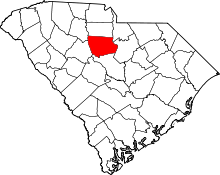 | |
| CDP | ||
| Unincorporated communities | ||
| Footnotes | ‡This populated place also has portions in an adjacent county or counties | |
Municipalities and communities of Richland County, South Carolina, United States | ||
|---|---|---|
| Cities | 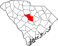 | |
| Towns | ||
| CDPs | ||
| Unincorporated communities | ||
| Footnotes | ‡This populated place also has portions in an adjacent county or counties | |