Blue Stack Mountains
| Blue Stack Mountains | |
|---|---|
| Irish: na Cruacha Gorma | |
 Binnasruell in the Blue Stack Mountains | |
| Highest point | |
| Peak | Croaghgorm |
| Elevation | 674 m (2,211 ft) |
| Coordinates | Coordinates: 54°45′27″N 7°58′17″W / 54.75750°N 7.97139°W |
| Geography | |
 Blue Stack Mountains | |
| Country | Republic of Ireland |
| Provinces of Ireland | Ulster |
The Blue Stack Mountains[1] or Bluestack Mountains, also called the Croaghgorms (Irish: na Cruacha Gorma, meaning "the blue stacks"), are the major mountain range in the south of County Donegal, Ireland. They provide a barrier between the south of the county, such as Donegal Town and Ballyshannon, and the towns to the north and west such as Dungloe and Letterkenny. The road between the two parts of the county goes through the Barnesmore Gap.
The highest mountain in the range is Croaghgorm, which is 674 metres high. Nearby summits include Ardnageer (642 m), Croaghanirwore (548 m), Croaghbarnes (499 m), Croaghblane (641 m), Croaghnageer (571 m), Croveenananta (476 m), Gaugin Mountain (565 m), Lacroagh (403 m), Lavagh More (671 m) and Lavagh Beg (650 m).[2]
Pictures
 Eglish Valley
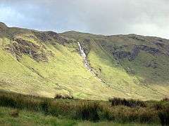 Binnasruell
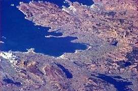 The Blue Stacks from earth orbit (top right)
References
- ↑ Blue Stack Mountains Placenames Database of Ireland. Retrieved: 2013-03-19
- ↑ Croaghgorm MountainViews. Retrieved: 2013-03-19.
External links
| Wikimedia Commons has media related to Blue Stack Mountains. |
Mountains and hills of Ulster | ||
|---|---|---|
| Antrim Hills |  | |
| Antrim Plateau | ||
| Belfast Hills | ||
| Breifne | ||
| Croaghgorms | ||
| Derryveagh | ||
| Inishowen | ||
| Mournes | ||
| Sperrins | ||
| Southwest Donegal | ||
| Others | ||