Bittenbender Covered Bridge
|
Bittenbender Covered Bridge | |
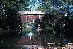 The bridge in 1982 | |
  | |
| Location | South of Huntington Mills off Legislative Route 40076, Huntington Township, Pennsylvania |
|---|---|
| Coordinates | 41°10′51″N 76°13′30″W / 41.18083°N 76.22500°WCoordinates: 41°10′51″N 76°13′30″W / 41.18083°N 76.22500°W |
| Area | 0.1 acres (0.040 ha) |
| Built | 1888 |
| Architect | Multiple |
| Architectural style | Other, Queenpost truss |
| MPS | Covered Bridges of the Delaware River Watershed TR |
| NRHP reference # | 80003563[1] |
| Added to NRHP | December 1, 1980 |
Bittenbender Covered Bridge was a historic wooden covered bridge in Huntington Township, Luzerne County, Pennsylvania. It was a 68.6-foot-long (20.9 m), Queenpost Truss bridge, constructed in 1888. It had rough vertical plank siding, crossed Huntington Creek, and was the last covered bridge in Luzerne County.[2]
It was listed on the National Register of Historic Places in 1980.[1] The bridge was destroyed in a flood on June 28, 2006.[3]
References
| Wikimedia Commons has media related to Bittenbender Covered Bridge. |
- 1 2 National Park Service (2010-07-09). "National Register Information System". National Register of Historic Places. National Park Service.
- ↑ "National Historic Landmarks & National Register of Historic Places in Pennsylvania" (Searchable database). CRGIS: Cultural Resources Geographic Information System. Note: This includes Susan M. Zacher (n.d.). "National Register of Historic Places Inventory Nomination Form: Bittenbender Covered Bridge" (PDF). Retrieved 2012-03-09.
- ↑ "Bittenbender, Luzerne County". Covered Spans of Yesteryear - www.lostbridges.org. Retrieved February 26, 2013.
| Topics |   | |
|---|---|---|
| Lists by county |
| |
| Lists by city | ||
| Other lists | ||
| ||
This article is issued from
Wikipedia.
The text is licensed under Creative Commons - Attribution - Sharealike.
Additional terms may apply for the media files.