Birigui
| Birigui | |||
|---|---|---|---|
| Municipality | |||
|
The Municipality of Birigüi | |||
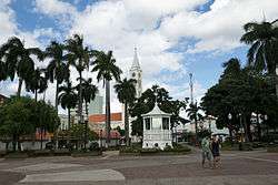 Praça Dr. Gama, marco central da cidade | |||
| |||
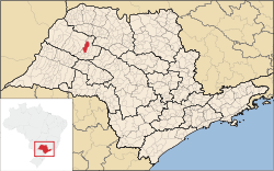 Location of Birigüi | |||
 Birigui Location in Brazil | |||
| Coordinates: 21°17′19″S 50°20′24″W / 21.28861°S 50.34000°WCoordinates: 21°17′19″S 50°20′24″W / 21.28861°S 50.34000°W | |||
| Country |
| ||
| Region | Southeast | ||
| State |
| ||
| Area | |||
| • Total | 530.9 km2 (205.0 sq mi) | ||
| Elevation | 406 m (1,332 ft) | ||
| Population (2010/IBGE) | |||
| • Total | 108,728 | ||
| • Density | 204.79/km2 (530.4/sq mi) | ||
| Time zone | UTC-3 (UTC-3) | ||
| • Summer (DST) | UTC-2 (UTC-2) | ||
| Postal Code | 16200-000 | ||
| Area code(s) | +55 18 | ||
| Website | Prefecture of Birigüi | ||

Birigui is a city in the state of São Paulo, Brazil. The city is located on the northwest of the state and has 108,728 inhabitants (IBGE/2010) and 530.9 km² of area.[1] Birigui is located 521 km from the city of São Paulo and 11 km from Araçatuba.
History
The city was founded in December 7, 1911, by Nicolau da Silva Nunes.[2] The name Birigüi comes from the Tupi–Guarani language and means "fly that always comes". It refers to the Lutzomyia fly, very common at the area.
Economy
The Tertiary sector corresponds to 71.12% of Birigüi's GDP. The Secondary sector is 27.07% of the GDP and the Primary sector corresponds to 1.8%.[3]
Birigüi is recognized for being the most important center of children's shoes production in Brazil with a production of 57 million pairs in the year of 2006. In the same year it had 159 industries in the children' shoe's segment and their profit was over 800 million reais (R$). Among all these industries there are over 18 thousand workers which consist in 60% of the jobs offered in all the city.[2]
Geographical Aspects
Located under the latitude 21º17'19" S and longitude 50º20'24" W.
Weather
According to Köppen climate classification Birigüi has a humid subtropical climate. Highest 36 °C and Lowest 4 °C.
Hydrography
Rivers: Tietê, Baixotes, Grande, Tabapuã, Ribeirão Baguaçu, Da Colônia, Do Imbé, Barro Preto, Água Branca
Demography
- Population: 108.728 inhabitants (IBGE/2010)[1]
- Demographic density (inhabitants/km²): 204.79
- Infantile mortality until 1 year old(in each thousand children): 9,64
- Life expectancy (years old): 74,96
- Fecundity rate (children by woman): 2,01
- Human development index (HDI): 0,829
- HDI Income: 0,761
- HDI Longevity: 0,833
- HDI Education: 0,893
(Source: IPEADATA)
Ethnography
- Colour/race Percentage
- White 78,0%
- Black 1,8%
- Brown 18,8%
- Yellow 1,1%
- Amerindian 0,2%
Education
The city has 10 day-nurseries, 21 EMEI (Municipal School of Infantile Education), 11 EMEFs (Municipal School of Basic Education), 5 State Schools of Basic Education, 7 State High Schools, 5 private High Schools and 3 universities.
Sports
Soccer and biribol, an aquatic version of volleyball are the most popular sports in the city. The soccer team, Bandeirante Esporte Clube, was founded on March 11, 1923 and its first president was José Troncoso, who currently names a street in the city. In 1987 the team played professionally in the Premier League of Campeonato Paulista (a championship in the state of São Paulo)
Biribol was invented in the city by the Teacher Dario Miguel Pedro.
Transportation
External links
- http://www.birigui.sp.gov.br/ Prefecture of Birigüi
- Birigüi's Municipal Chamber
References
- 1 2 "Population at "Censo 2010"" (PDF) (in Portuguese). IBGE.gov.br. Retrieved 28 Jul 2011.
- 1 2 "History of the City". Birigui.sp.gov.br. Archived from the original on 1 August 2011. Retrieved 29 July 2011.
- ↑ "Municipal Profile at SEADE - Search" (in Portuguese). SEADE.gov.br. Archived from the original on 23 August 2011. Retrieved 28 July 2011.